
Aerial photo of Mount Shasta's southwestern flank in a low-snow period. The Hotlum cone is on the right, while the Shastina dome is to the left.
Images
Images intro.
Filter Total Items: 83

Mount Shasta, CA
Aerial photo of Mount Shasta's southwestern flank in a low-snow period. The Hotlum cone is on the right, while the Shastina dome is to the left.
Map of the known ash-fall boundaries for several U.S. eruptions
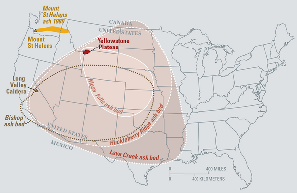
Eruptions of the Yellowstone volcanic system have included the two largest volcanic eruptions in North America in the past few million years; the third largest was at Long Valley in California and produced the Bishop ash bed. The biggest of the Yellowstone eruptions occurred 2.1 million years ago, depositing the Huckleberry Ridge ash bed.
Eruptions of the Yellowstone volcanic system have included the two largest volcanic eruptions in North America in the past few million years; the third largest was at Long Valley in California and produced the Bishop ash bed. The biggest of the Yellowstone eruptions occurred 2.1 million years ago, depositing the Huckleberry Ridge ash bed.

USGS scientists measuring temperature in a deep borehole in the Long Valley Caldera
USGS scientists measuring temperature in a deep borehole in Long Valley Caldera with the Sierra Nevada mountains in the background.
USGS scientists measuring temperature in a deep borehole in Long Valley Caldera with the Sierra Nevada mountains in the background.

Gas bubbles through a sample bottle containing alkaline solution
Gas bubbles through a sample bottle containing alkaline solution, allowing for separation of different gas phases.
Gas bubbles through a sample bottle containing alkaline solution, allowing for separation of different gas phases.

Map of volcanic ash fall as a result of eruptions from Yellowstone,...
Map of volcanic ashfall. Areas of the United States that once were covered by volcanic ash from Yellowstone's giant eruptions 2 million and 630,000 years ago, compared with ashfall from the 760,000-year-old Long Valley caldera eruptions at Mammoth Lakes, California, and the 1980 eruption of Mount St. Helens, Washington.
Map of volcanic ashfall. Areas of the United States that once were covered by volcanic ash from Yellowstone's giant eruptions 2 million and 630,000 years ago, compared with ashfall from the 760,000-year-old Long Valley caldera eruptions at Mammoth Lakes, California, and the 1980 eruption of Mount St. Helens, Washington.

View of the Mono Lake-Long Valley volcanic region
An aerial view looking south of the Long Valley volcanic region in the area of Mono Lake, showing a line of rhyolite lava domes and explosion craters. An inset map shows the locations of silcic magmatic centers in the Long Valley area.
An aerial view looking south of the Long Valley volcanic region in the area of Mono Lake, showing a line of rhyolite lava domes and explosion craters. An inset map shows the locations of silcic magmatic centers in the Long Valley area.

Coso Volcanic Field Tumulus
A tumulus in the Coso Volcanic Field, California. This lava was probably more viscous than the lava found in the Hawaii tumuli.
A tumulus in the Coso Volcanic Field, California. This lava was probably more viscous than the lava found in the Hawaii tumuli.

Mount Konocti, a 1,312 m (4,305 ft) mountain on the eastern shore o...
Mt. Konocti erupted during the most recent stage of volcanism (01. Ma to 10,000 years ago), and a future eruption from the same site would be devastating to the nearby inhabitants.
Mt. Konocti erupted during the most recent stage of volcanism (01. Ma to 10,000 years ago), and a future eruption from the same site would be devastating to the nearby inhabitants.

Mount Konocti viewed from Cinder Cone, Clear Lake Volcanic Field.
Mount Konocti, the most distinct volcanic feature of the Clear Lake Volcanics as viewed to the west from Cinder Cone.
Mount Konocti, the most distinct volcanic feature of the Clear Lake Volcanics as viewed to the west from Cinder Cone.

Lassen Peak's Devastated Area photographed from the air in 1994.
Lassen Peak's Devastated Area photographed from the air in 1994.
Lassen Peak's Devastated Area photographed from the air in 1994.

Mount Konocti on the western shore of Clear Lake, California
Mount Konocti, a mostly dacitic composite cone, on the western shore of Clear Lake, California. Thurston Lake is in the foreground.
Mount Konocti, a mostly dacitic composite cone, on the western shore of Clear Lake, California. Thurston Lake is in the foreground.

California's Exposure to Volcanic Hazards
Infographic about the 2019 report "California's Exposure to Volcanic Hazards"
Infographic about the 2019 report "California's Exposure to Volcanic Hazards"

USGS Director Jim Reilly being given a tour of the CalVO
In a February 5, 2019 visit, USGS Director Jim Reilly was given a tour of CalVO facilities, including the Operations Room. Here Emily Montgomery-Brown explains the networks that monitor California's threatening volcanoes.
In a February 5, 2019 visit, USGS Director Jim Reilly was given a tour of CalVO facilities, including the Operations Room. Here Emily Montgomery-Brown explains the networks that monitor California's threatening volcanoes.

Lassen Volcano Observatory, 1926
The original Lassen Volcano Observatory building, provided by the US Forest Service, about 1926. The observatory consisted of a small office over a 10x10 ft concrete cellar which housed two custom-built seismographs. A small cottage nearby housed Ruy H. Finch, the head of and sole scientist at the Observatory for much of its existence. (Photo by R.H.
The original Lassen Volcano Observatory building, provided by the US Forest Service, about 1926. The observatory consisted of a small office over a 10x10 ft concrete cellar which housed two custom-built seismographs. A small cottage nearby housed Ruy H. Finch, the head of and sole scientist at the Observatory for much of its existence. (Photo by R.H.

Ruy H. Finch (1890-1957)
The founder of the Lassen Volcano Observatory (1926-1935) and second Director of the Hawaiian Volcano Observatory (1940-1951), Ruy Herbert Finch conducted research in both Hawaii and throughout the Western United States.
The founder of the Lassen Volcano Observatory (1926-1935) and second Director of the Hawaiian Volcano Observatory (1940-1951), Ruy Herbert Finch conducted research in both Hawaii and throughout the Western United States.

Coso Hot Springs located at Coso Volcanic Field, CA
Coso Hot Springs in Coso volanic fields, Feb 4, 1920.
Coso Hot Springs in Coso volanic fields, Feb 4, 1920.

Lassen Peak photographed from the Devastated Area about 4 hours bef...
Lassen Peak photographed from the Devastated Area about 4 hours before the explosive eruption of May 22, 1915.
Lassen Peak photographed from the Devastated Area about 4 hours before the explosive eruption of May 22, 1915.

Lassen Peak photographed from the Devastated Area prior to 1914-191...
Lassen Peak photographed from the Devastated Area prior to the 1914-1915 eruption that changed the landscape.
Lassen Peak photographed from the Devastated Area prior to the 1914-1915 eruption that changed the landscape.

Stereograph photo of Mount Shasta and the town of Sisson in 1906
Horse-drawn carriage on road in Sisson, California, El Monte Hotel in foreground, Mount Shasta in the background. Image courtesy of the Library of Congress.
Horse-drawn carriage on road in Sisson, California, El Monte Hotel in foreground, Mount Shasta in the background. Image courtesy of the Library of Congress.

Town of Sisson at the foot of Mount Shasta in winter, ca.1900
Photograph of the town of Sisson (later (1922) the town of Mt. Shasta) in the distance at the foot of Mount Shasta in winter. Snow covered fir trees in the foreground. Photo courtesy of University of Southern California Libraries and California Historical Society. Digitally reproduced by the USC Digital Library.
Photograph of the town of Sisson (later (1922) the town of Mt. Shasta) in the distance at the foot of Mount Shasta in winter. Snow covered fir trees in the foreground. Photo courtesy of University of Southern California Libraries and California Historical Society. Digitally reproduced by the USC Digital Library.