
Using a thermal image of the crack above Kīlauea volcano's ocean entry (steam from lava flowing into the sea is visible at the top of the left photo), HVO geologists determined that the temperature within the eastern end of the crack is up to about 220 degrees Celsius (428 degrees Fahrenheit).
Images
Hawaiian Volcano Observatory images of eruptive activity, field work, and more.
Filter Total Items: 2879

Using a thermal image of the crack above Kīlauea's ocean entry (ste...
Using a thermal image of the crack above Kīlauea volcano's ocean entry (steam from lava flowing into the sea is visible at the top of the left photo), HVO geologists determined that the temperature within the eastern end of the crack is up to about 220 degrees Celsius (428 degrees Fahrenheit).

At Kīlauea's ocean entry on Jan. 28 and 29, the interaction of molt...
At Kīlauea's ocean entry on Jan. 28 and 29, the interaction of molten lava flowing into cool seawater caused pulsating littoral explosions that threw spatter (fragments of molten lava) high into the air. Some of these incandescent clasts fell on top of the sea cliff behind the ocean entry, forming a small spatter cone.
At Kīlauea's ocean entry on Jan. 28 and 29, the interaction of molten lava flowing into cool seawater caused pulsating littoral explosions that threw spatter (fragments of molten lava) high into the air. Some of these incandescent clasts fell on top of the sea cliff behind the ocean entry, forming a small spatter cone.

Ground crack at Kīlauea ocean entry is cause for concern
Due to the instability of the sea cliff above the ocean entry and other hazards created by molten lava flowing into the sea, Hawai‘i Volcanoes National Park has established a viewing area (noted by yellow arrow in photo) from which the ocean entry can be seen in relative safety.
Due to the instability of the sea cliff above the ocean entry and other hazards created by molten lava flowing into the sea, Hawai‘i Volcanoes National Park has established a viewing area (noted by yellow arrow in photo) from which the ocean entry can be seen in relative safety.

The ups and downs of Kīlauea's summit lava lake
Kīlauea Volcano's summit lava lake level typically rises and falls in concert with summit inflation and deflation, as shown by these two HVO webcam images. The left image was captured a week ago (on Jan. 17, 2017), when the lava level was 52.5 m (172 ft) below the vent rim, the lowest level measured since April 8, 2016. The right image, captured this morning (Jan.
Kīlauea Volcano's summit lava lake level typically rises and falls in concert with summit inflation and deflation, as shown by these two HVO webcam images. The left image was captured a week ago (on Jan. 17, 2017), when the lava level was 52.5 m (172 ft) below the vent rim, the lowest level measured since April 8, 2016. The right image, captured this morning (Jan.

This video clip of Kīlauea's summit lava lake shows spattering alon...
This video clip of Kīlauea Volcano's summit lava lake shows spattering along the southeast margin of the lake.
This video clip of Kīlauea Volcano's summit lava lake shows spattering along the southeast margin of the lake.

Spattering along a down-welling section of Kīlauea Volcano's summit
This telephoto image from January 19, 2017, shows spattering along a down-welling section of Kīlauea Volcano's summit lava lake. The main area of spattering was about 10 m (32 ft) high, but some lava fragments were thrown even higher.
This telephoto image from January 19, 2017, shows spattering along a down-welling section of Kīlauea Volcano's summit lava lake. The main area of spattering was about 10 m (32 ft) high, but some lava fragments were thrown even higher.
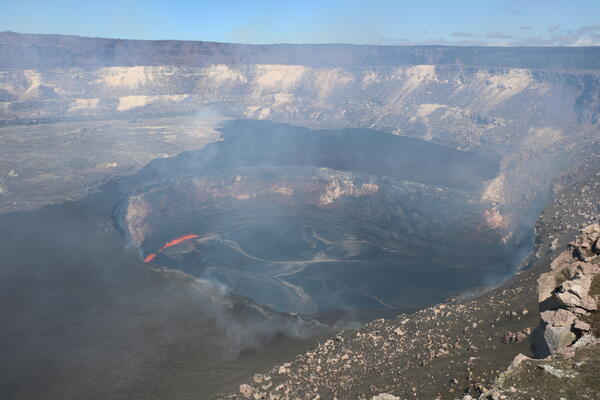
Lower level of Kīlauea's summit lava lake exposes vent wall
The summit lava lake within Halema‘uma‘u Crater today (Jan. 15, 2017) was about 50.5 m (166 ft) below the crater floor (vent rim). One of the most interesting things exposed by the lower lake level was the clear view of the thick, dark veneer of lava on the eastern vent wall (close-up shown below).
The summit lava lake within Halema‘uma‘u Crater today (Jan. 15, 2017) was about 50.5 m (166 ft) below the crater floor (vent rim). One of the most interesting things exposed by the lower lake level was the clear view of the thick, dark veneer of lava on the eastern vent wall (close-up shown below).

panoramic view of the 1935 Humu‘ula flow
This panoramic view of the 1935 Humu‘ula flow (black lava) on both sides of the Daniel K. Inouye Highway, which runs east to west in the saddle between Mauna Loa (snow-capped shield volcano at far left) and Mauna Kea (distant right), was taken from the top of Pu‘uhuluhulu. View is to the northwest. The top of Hualālai is visible in far distance (center).
This panoramic view of the 1935 Humu‘ula flow (black lava) on both sides of the Daniel K. Inouye Highway, which runs east to west in the saddle between Mauna Loa (snow-capped shield volcano at far left) and Mauna Kea (distant right), was taken from the top of Pu‘uhuluhulu. View is to the northwest. The top of Hualālai is visible in far distance (center).

Flooded tiltmeter casing
A tiltmeter on the south flank of Kīlauea volcano flooded with water. The tiltmeter casing is less than a foot in diameter. USGS photo.
A tiltmeter on the south flank of Kīlauea volcano flooded with water. The tiltmeter casing is less than a foot in diameter. USGS photo.

Combined vacuums
The HVO dual vacuum set up used to extract wet sand from flooded tiltmeter casings. USGS photo.
The HVO dual vacuum set up used to extract wet sand from flooded tiltmeter casings. USGS photo.

Kīlauea's ERZ eruption: what happened in 2017
On May 24, 2016, two new flows broke out on the flanks of the Pu‘u ‘Ō‘ō cone on Kīlauea Volcano's East Rift Zone. The silvery sheen of new lava erupting from the northern 61f breakout (center) and eastern 61g breakout (upper left) stands out in contrast to the older flows on and around Pu‘u ‘Ō‘ō (right).
On May 24, 2016, two new flows broke out on the flanks of the Pu‘u ‘Ō‘ō cone on Kīlauea Volcano's East Rift Zone. The silvery sheen of new lava erupting from the northern 61f breakout (center) and eastern 61g breakout (upper left) stands out in contrast to the older flows on and around Pu‘u ‘Ō‘ō (right).

An assumption about Kīlauea is proven wrong
A past assumption about pumice deposits on Kīlauea Volcano has recently been proven wrong. In this photo, the eastern pumice (EP) can be seen above the golden pumice (GP), with stream deposits between the two. Photo courtesy of Sebastien Biasse, University of Hawai‘i at Mānoa.
A past assumption about pumice deposits on Kīlauea Volcano has recently been proven wrong. In this photo, the eastern pumice (EP) can be seen above the golden pumice (GP), with stream deposits between the two. Photo courtesy of Sebastien Biasse, University of Hawai‘i at Mānoa.

Seabirds struggle for survival on Mauna Loa
A young 'ua'u exercises its wings in preparation for its first flight directly out to sea. The 'ua'u, or Hawaiian petrel, is a federally endangered native seabird that nests at high elevations on Mauna Loa volcano.
A young 'ua'u exercises its wings in preparation for its first flight directly out to sea. The 'ua'u, or Hawaiian petrel, is a federally endangered native seabird that nests at high elevations on Mauna Loa volcano.

Pele's hair provides clues about Kīlauea lava
A USGS-HVO scientist collects Pele's hair from the parking area south of Halema‘uma‘u Crater, which has been closed since early 2008 due to ongoing volcano hazards associated with the summit lava lake.
A USGS-HVO scientist collects Pele's hair from the parking area south of Halema‘uma‘u Crater, which has been closed since early 2008 due to ongoing volcano hazards associated with the summit lava lake.

A close-up of Pele's hair from Kīlauea's summit lava lake. X-ray d...
A close-up of Pele's hair from Kīlauea Volcano's summit lava lake. X-ray diffraction analyses of the Pele's hair (basaltic glass) collected today will provide information on the mineralogy of Kīlauea lava, which, in turn, can shed light whether the magma supply to the volcano is constant or is changing.
A close-up of Pele's hair from Kīlauea Volcano's summit lava lake. X-ray diffraction analyses of the Pele's hair (basaltic glass) collected today will provide information on the mineralogy of Kīlauea lava, which, in turn, can shed light whether the magma supply to the volcano is constant or is changing.

Beautiful weather at Kīlauea makes for spectacular views
This photo shows the Hawaiian Volcano Observatory and the Hawai‘i Volcanoes National Park Service Jaggar Museum buildings on the summit of Kīlauea Volcano, overlooking the summit caldera. Mauna Loa volcano looms in the background.
This photo shows the Hawaiian Volcano Observatory and the Hawai‘i Volcanoes National Park Service Jaggar Museum buildings on the summit of Kīlauea Volcano, overlooking the summit caldera. Mauna Loa volcano looms in the background.

This view shows Kīlauea's summit lava from the south, with the east...
This view shows Kīlauea's summit lava from the south, with the east slope of Mauna Loa in the background and Mauna Kea in the distance. The Hawaiian Volcano Observatory and the Hawai‘i National Park Service Jaggar Museum buildings are visible on the rim of Kīlauea's summit caldera, behind Halema‘uma‘u.
This view shows Kīlauea's summit lava from the south, with the east slope of Mauna Loa in the background and Mauna Kea in the distance. The Hawaiian Volcano Observatory and the Hawai‘i National Park Service Jaggar Museum buildings are visible on the rim of Kīlauea's summit caldera, behind Halema‘uma‘u.

A brief overflow of Kīlauea's summit lava lake on Oct. 16
On Saturday, October 15, Kīlauea Volcano's summit lava lake overflowed the vent rim between 1:00 and 2:00 p.m., and again around 6:30 p.m., HST. In this image, captured by HVO's K2 webcam, you can see small spill-overs (shiny black lava) on the east (far left) and west (right) sides of the vent rim.
On Saturday, October 15, Kīlauea Volcano's summit lava lake overflowed the vent rim between 1:00 and 2:00 p.m., and again around 6:30 p.m., HST. In this image, captured by HVO's K2 webcam, you can see small spill-overs (shiny black lava) on the east (far left) and west (right) sides of the vent rim.

typical spattering activity in Kīlauea's summit lava lake. This sp...
This video clip shows typical spattering activity in Kīlauea's summit lava lake. This spattering was occurring along the eastern margin of the lake on the evening of October 5.
This video clip shows typical spattering activity in Kīlauea's summit lava lake. This spattering was occurring along the eastern margin of the lake on the evening of October 5.

Continued spattering in Kīlauea's summit lava lake
This morning, spattering along the eastern margin of Kīlauea's summit lava lake built an overhanging ledge that was attached to the Overlook Crater wall. In this image, a few long stalactites can be seen dangling from the overhang (lower right). These stalactites were flexible enough to be swinging back and forth.
This morning, spattering along the eastern margin of Kīlauea's summit lava lake built an overhanging ledge that was attached to the Overlook Crater wall. In this image, a few long stalactites can be seen dangling from the overhang (lower right). These stalactites were flexible enough to be swinging back and forth.

spattering in two locations of Kīlauea's summit lava lake. In the ...
This video shows spattering in two locations of Kīlauea's summit lava lake. In the first segment, spattering is active in a small area in the southern portion of the lake. In the second segment, spattering on the east margin of the lake has created an overhanging ledge with dangling lava stalactites.
This video shows spattering in two locations of Kīlauea's summit lava lake. In the first segment, spattering is active in a small area in the southern portion of the lake. In the second segment, spattering on the east margin of the lake has created an overhanging ledge with dangling lava stalactites.