
Images of olivine from Hawaiian volcanoes. In olivine the abundance of magnesium (Mg) is expressed as the forsterite content (Fo)—which is a ratio of how much Mg there is compared to the iron (Fe). Left: Green olivine from Mauna Loa’s 1852 eruption, viewed under a microscope. USGS 
Images
Hawaiian Volcano Observatory images of eruptive activity, field work, and more.
Filter Total Items: 2896

Tracking magma movement using olivine crystal “clocks”
Images of olivine from Hawaiian volcanoes. In olivine the abundance of magnesium (Mg) is expressed as the forsterite content (Fo)—which is a ratio of how much Mg there is compared to the iron (Fe). Left: Green olivine from Mauna Loa’s 1852 eruption, viewed under a microscope. USGS 

Lava lake in Halema‘uma‘u, Kīlauea summit - November 1, 2021
A wide view of the lava lake in Halema‘uma‘u, at the summit of Kīlauea, on November 1, 2021. This view, looking east, shows the west vent (bottom center) which continues to supply lava to the active portion of the lava lake, while the eastern portion (far side of lake) is crusted over.
A wide view of the lava lake in Halema‘uma‘u, at the summit of Kīlauea, on November 1, 2021. This view, looking east, shows the west vent (bottom center) which continues to supply lava to the active portion of the lava lake, while the eastern portion (far side of lake) is crusted over.

Halema‘uma‘u lava lake at Kīlauea summit - November 1, 2021
A telephoto image of the northeast margin of the lava lake within Halema‘uma‘u, at Kīlauea summit, on November 1, 2021. The lava lake has now risen high enough to start covering the lowest portion of the down-dropped block on the north side of Halema‘uma‘u.
A telephoto image of the northeast margin of the lava lake within Halema‘uma‘u, at Kīlauea summit, on November 1, 2021. The lava lake has now risen high enough to start covering the lowest portion of the down-dropped block on the north side of Halema‘uma‘u.

West vent fountain sequence, Halema‘uma‘u, Kīlauea summit—Nov. 1, 2021
A sequence of telephoto images of the west vent (spanning 4 seconds), within Halema‘uma‘u at Kīlauea summit. The west vent continues to produce low-level lava fountains (seen here), which are forming an elevated pond of lava within the spatter cone.
A sequence of telephoto images of the west vent (spanning 4 seconds), within Halema‘uma‘u at Kīlauea summit. The west vent continues to produce low-level lava fountains (seen here), which are forming an elevated pond of lava within the spatter cone.

sim3143_sheet5.jpg
The USGS recently published a revised “Geologic map of the State of Hawaii (usgs.gov).” This map—originally published in 2007—has been updated to include more recent geologic deposits, including lava flows from Kīlauea’s Pu‘u‘ō‘ō vent on the middle East Rift Zone from 2007–2018 and l
The USGS recently published a revised “Geologic map of the State of Hawaii (usgs.gov).” This map—originally published in 2007—has been updated to include more recent geologic deposits, including lava flows from Kīlauea’s Pu‘u‘ō‘ō vent on the middle East Rift Zone from 2007–2018 and l

Halema‘uma‘u lava lake, Kīlauea summit eruption—October 15, 2021
The Kīlauea summit eruption continues within Halema‘uma‘u, in Hawai‘i Volcanoes National Park. This photo of the lava lake was taken this morning, October 15, 2021, during a Hawaiian Volcano Observatory eruption overflight. The vent in the western crater wall (center) continues to supply lava into the lava lake.
The Kīlauea summit eruption continues within Halema‘uma‘u, in Hawai‘i Volcanoes National Park. This photo of the lava lake was taken this morning, October 15, 2021, during a Hawaiian Volcano Observatory eruption overflight. The vent in the western crater wall (center) continues to supply lava into the lava lake.

West vent in Halema‘uma‘u, Kīlauea summit eruption—Oct. 15 2021
A close-up view of the west vent on the western crater wall of Halema‘uma‘u, at Kīlauea summit. Fountaining and lava spatter has built a cone around the vent. Lava pools in the cone and then pours into the lava lake through a small spillway. This photo was taken during a monitoring helicopter overflight on October 15, 2021. USGS photo by N. Deligne.
A close-up view of the west vent on the western crater wall of Halema‘uma‘u, at Kīlauea summit. Fountaining and lava spatter has built a cone around the vent. Lava pools in the cone and then pours into the lava lake through a small spillway. This photo was taken during a monitoring helicopter overflight on October 15, 2021. USGS photo by N. Deligne.

West vent in Halema‘uma‘u, Kīlauea summit eruption—Oct. 15 2021
A telephoto view of the west vent supplying lava to the lava lake in Halema‘uma‘u, at Kīlauea summit. In the bottom right, the western fissure complex from the Dec. 2020–May 2021 eruption is visible as a spiny dull dark brown and red feature.
A telephoto view of the west vent supplying lava to the lava lake in Halema‘uma‘u, at Kīlauea summit. In the bottom right, the western fissure complex from the Dec. 2020–May 2021 eruption is visible as a spiny dull dark brown and red feature.

Scientist collects data—Kīlauea eruption overflight—Oct. 15, 2021
Hawaiian Volcano Observatory scientists make observations and collect data during Kīlauea eruption overflights. The data collected is used to construct updated topographic and thermal maps of the lava lake surface and surrounding area.
Hawaiian Volcano Observatory scientists make observations and collect data during Kīlauea eruption overflights. The data collected is used to construct updated topographic and thermal maps of the lava lake surface and surrounding area.

Active west vent in Halema‘uma‘u—October 15, 2021
A telephoto image of the the west vent taken on the morning of October 15, during an HVO helicopter overflight of Kīlauea summit. Low lava fountaining activity continues from the vent in the western wall of Halema‘uma‘u.
A telephoto image of the the west vent taken on the morning of October 15, during an HVO helicopter overflight of Kīlauea summit. Low lava fountaining activity continues from the vent in the western wall of Halema‘uma‘u.

Halema‘uma‘u Lave Lake—October 15, 2021
The eruption within Halema‘uma‘u continues. Lava fountaining from the western vent (center) feeds a rising lava lake. Activity has decreased over the past week and much of the eastern half of the lake surface (seen here in the foreground) has cooled and formed a solid crust.
The eruption within Halema‘uma‘u continues. Lava fountaining from the western vent (center) feeds a rising lava lake. Activity has decreased over the past week and much of the eastern half of the lake surface (seen here in the foreground) has cooled and formed a solid crust.

West vent and lava lake islands—October 15, 2021
In this photo taken during a helicopter overflight of Halema‘uma‘u crater on October 15, lava can be seen fountaining within the western vent cone and flowing down a short spillway into the lava lake. The main island created in the initial stages of the Dec. 2020–May 2021 eruption is in the foreground and continues to rise with the lake surface.
In this photo taken during a helicopter overflight of Halema‘uma‘u crater on October 15, lava can be seen fountaining within the western vent cone and flowing down a short spillway into the lava lake. The main island created in the initial stages of the Dec. 2020–May 2021 eruption is in the foreground and continues to rise with the lake surface.

Kīlauea summit eruption - October 15, 2021
This overview photo of the Halema‘uma‘u lava lake was captured around noon on Friday, October 15, 2021, from the northwest rim of the crater. The western fissure (lower right) continues to erupt lava into the west side of the lava lake (right). The east side of the lake (left) is mostly stagnated and solidified on the surface.
This overview photo of the Halema‘uma‘u lava lake was captured around noon on Friday, October 15, 2021, from the northwest rim of the crater. The western fissure (lower right) continues to erupt lava into the west side of the lava lake (right). The east side of the lake (left) is mostly stagnated and solidified on the surface.

Lava fountaining at the west vent—October 14, 2021
A close-up photo of the vent in the western wall of Halema‘uma‘u, taken during the ongoing eruption at Kīlauea summit. The top of the 5–6 m (16–20 ft) tall lava fountain could be seen from the west crater rim on October 14, at 2:05 p.m. The lava fountains continue to build up a spatter cone around the vent.
A close-up photo of the vent in the western wall of Halema‘uma‘u, taken during the ongoing eruption at Kīlauea summit. The top of the 5–6 m (16–20 ft) tall lava fountain could be seen from the west crater rim on October 14, at 2:05 p.m. The lava fountains continue to build up a spatter cone around the vent.

October 13, 2021 — Kīlauea summit eruption
A view of the western portion of the lava lake within Halema‘uma‘u, at the summit of Kīlauea. This photo, taken from the west crater rim, shows the active west vent (lower right), the main island (upper left), and the old west vent from the Dec. 2020–May 2021 eruption (lower left).
A view of the western portion of the lava lake within Halema‘uma‘u, at the summit of Kīlauea. This photo, taken from the west crater rim, shows the active west vent (lower right), the main island (upper left), and the old west vent from the Dec. 2020–May 2021 eruption (lower left).

Kīlauea summit eruption - October 12, 2021
A view of the fountaining at the west vent in Halema‘uma‘u crater, at the summit of Kīlauea. The photo was taken from the west rim, looking down upon the vent. Low fountaining and roiling within the cone supplied lava to the lake via a narrow spillway. Lava spreading out into the lake develops a zig-zag pattern in the surface crust. USGS photo by M.
A view of the fountaining at the west vent in Halema‘uma‘u crater, at the summit of Kīlauea. The photo was taken from the west rim, looking down upon the vent. Low fountaining and roiling within the cone supplied lava to the lake via a narrow spillway. Lava spreading out into the lake develops a zig-zag pattern in the surface crust. USGS photo by M.

Kīlauea summit eruption - October 12, 2021
A wide view of the ongoing eruption at Kīlauea summit, from the south rim of Halema‘uma‘u. A vent on the western crater wall (left) continues to supply lava to the active west half of the lava lake.
A wide view of the ongoing eruption at Kīlauea summit, from the south rim of Halema‘uma‘u. A vent on the western crater wall (left) continues to supply lava to the active west half of the lava lake.

Kīlauea summit eruption - October 12, 2021
Associated with an increase in fountaining activity at the main western vent in Halema‘uma‘u, a short-lived vent opened just to the north (right). Activity at this vent lasted about 10 hours with low-level fountaining about 3 meters (10 ft) high.
Associated with an increase in fountaining activity at the main western vent in Halema‘uma‘u, a short-lived vent opened just to the north (right). Activity at this vent lasted about 10 hours with low-level fountaining about 3 meters (10 ft) high.
Kīlauea summit eruption - October 12, 2021
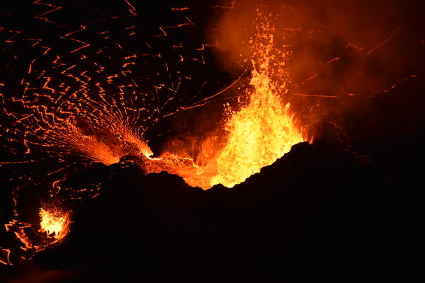
Lava fountains from the western vent within Halema‘uma‘u continue to supply lava into the lava lake through a short spillway. Consistent fountain heights of 10–15 meters (30–50 ft) were interrupted by frequent larger busts of spatter exceeding the height of the cone (30 m or 100 ft). USGS photo taken by B. Carr on October 12, 2021.
Lava fountains from the western vent within Halema‘uma‘u continue to supply lava into the lava lake through a short spillway. Consistent fountain heights of 10–15 meters (30–50 ft) were interrupted by frequent larger busts of spatter exceeding the height of the cone (30 m or 100 ft). USGS photo taken by B. Carr on October 12, 2021.

VMAP Vog Dashboard: public forecast for October 11, 2021
VMAP Vog Dashboard: public forecast for October 11, 2021. Colors denote probability of exceeding ‘Moderate’ sulfur dioxide air quality threshold. Source: http://weather.hawaii.edu/vmap/new/
VMAP Vog Dashboard: public forecast for October 11, 2021. Colors denote probability of exceeding ‘Moderate’ sulfur dioxide air quality threshold. Source: http://weather.hawaii.edu/vmap/new/

October 11, 2021 — Kīlauea
This zoomed-in view of the western fissure within Halema‘uma‘u, at the summit of Kīlauea, was captured on October 11, 2021, through the lens of a laser rangefinder. A prominent horseshoe-shaped spatter cone, measured to be standing 28 m (92 ft) above the adjacent lava lake, surrounds a roiling lava pond which also hosts taller fountains at times.
This zoomed-in view of the western fissure within Halema‘uma‘u, at the summit of Kīlauea, was captured on October 11, 2021, through the lens of a laser rangefinder. A prominent horseshoe-shaped spatter cone, measured to be standing 28 m (92 ft) above the adjacent lava lake, surrounds a roiling lava pond which also hosts taller fountains at times.