
USGS Hawaiian Volcano Observatory and DOI Office of Aviation staff prepare the sampling mechanism (on blue tarp) and inspect the Unmanned Aircraft System (UAS) just before it took off to collect water from the Halema‘uma‘u crater lake.
Images
Hawaiian Volcano Observatory images of eruptive activity, field work, and more.
Filter Total Items: 2879

HVO scientists prepare UAS for Kīlauea summit crater lake sampling
USGS Hawaiian Volcano Observatory and DOI Office of Aviation staff prepare the sampling mechanism (on blue tarp) and inspect the Unmanned Aircraft System (UAS) just before it took off to collect water from the Halema‘uma‘u crater lake.

Mauna Loa sulphur cone
Sulphur Cone (left), viewed toward southwest, from 3,480 m (11,420 ft) above sea level on Mauna Loa’s southwest rift zone. At right, an HVO geoscientist and technician rebuild volcanic gas monitoring equipment installed near an outgassing fissure.
Sulphur Cone (left), viewed toward southwest, from 3,480 m (11,420 ft) above sea level on Mauna Loa’s southwest rift zone. At right, an HVO geoscientist and technician rebuild volcanic gas monitoring equipment installed near an outgassing fissure.

Geophysicist Sarah Conway, USGS HVO geophysicist
Geophysicist Sarah Conway, a member of the USGS Hawaiian Volcano Observatory's deformation team, readies a temporary GPS station during a campaign survey of benchmarks on Kīlauea Volcano to monitor changes in the ground surface.
Geophysicist Sarah Conway, a member of the USGS Hawaiian Volcano Observatory's deformation team, readies a temporary GPS station during a campaign survey of benchmarks on Kīlauea Volcano to monitor changes in the ground surface.

Mountain Ararat
Glacier caps Greater Ararat, looking 30 km (19 miles) north through hotel window in Dogubeyazit, Turkey, September 16, 2019. Photo by Don Swanson.
Glacier caps Greater Ararat, looking 30 km (19 miles) north through hotel window in Dogubeyazit, Turkey, September 16, 2019. Photo by Don Swanson.
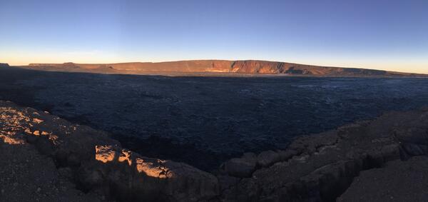
early morning view looking north across Moku‘āweoweo
An early morning view looking north across Moku‘āweoweo, Mauna Loa's summit caldera, from a spot near the summit cabin on the volcano's south caldera rim. Frost covered much of the caldera floor that was still shadowed, and weak steaming issued from the usual areas. Overall, there were no significant changes observed at the summit.
An early morning view looking north across Moku‘āweoweo, Mauna Loa's summit caldera, from a spot near the summit cabin on the volcano's south caldera rim. Frost covered much of the caldera floor that was still shadowed, and weak steaming issued from the usual areas. Overall, there were no significant changes observed at the summit.

Water pond in Halema‘uma‘u 8-18-19
Water pond in Halema‘uma‘u August 18, 2019. The water level continues to slowly rise in Halema‘uma‘u, drowning many of the small rocks that were previously exposed in the center of the pond. Ripples across the water surface were evident today.
Water pond in Halema‘uma‘u August 18, 2019. The water level continues to slowly rise in Halema‘uma‘u, drowning many of the small rocks that were previously exposed in the center of the pond. Ripples across the water surface were evident today.

Aerial view of the Halema‘uma‘u water pond
The ponded water at the bottom of Halema‘uma‘u has continued to slowly rise. This wide view shows much of Halema‘uma‘u and the fumaroles on the upper walls of the pit.
The ponded water at the bottom of Halema‘uma‘u has continued to slowly rise. This wide view shows much of Halema‘uma‘u and the fumaroles on the upper walls of the pit.

What does water in Halema‘uma‘u mean
These images look east at the pond within Halema‘uma‘u on August 8 and 14, 2019. The pond widened mainly toward the south (right). The north-south width of the pond on August 14 was about 32 m (105 ft), about 10 m (35 ft) wider than on August 8. The pond has widened and deepened slowly and steadily rate since measurements began on August 3.
These images look east at the pond within Halema‘uma‘u on August 8 and 14, 2019. The pond widened mainly toward the south (right). The north-south width of the pond on August 14 was about 32 m (105 ft), about 10 m (35 ft) wider than on August 8. The pond has widened and deepened slowly and steadily rate since measurements began on August 3.

HVO now tracking ponds of water, not lava, at Kīlauea's summit
A telephoto view of the ponded water at the bottom of Halema‘uma‘u on August 7, 2019. For scale, the largest pond is about 15 meters (50 feet) in diameter.
A telephoto view of the ponded water at the bottom of Halema‘uma‘u on August 7, 2019. For scale, the largest pond is about 15 meters (50 feet) in diameter.

Two HVO geologists document road cutting activities on HWY 132
Two HVO geologists document road cutting activities on HWY 132 on August 7, 2019. One geologist is taking visual photographs while another geologist is taking thermal photographs to make a tandem pair for comparison. The temperature of the solidified lava was measured to 425° C (800° F) at the digging site.
Two HVO geologists document road cutting activities on HWY 132 on August 7, 2019. One geologist is taking visual photographs while another geologist is taking thermal photographs to make a tandem pair for comparison. The temperature of the solidified lava was measured to 425° C (800° F) at the digging site.

Aerial view of Halema‘uma‘u at the summit of Kīlauea
Aerial view of Halema‘uma‘u at the summit of Kīlauea taken during a USGS Hawaiian Volcano Observatory helicopter overflight on August 1, 2019. The small green patch visible at the bottom of Halema‘uma‘u is a new pond forming at the lowest point of the crater. The pond is at about 525 m (about 1722 ft) elevation.
Aerial view of Halema‘uma‘u at the summit of Kīlauea taken during a USGS Hawaiian Volcano Observatory helicopter overflight on August 1, 2019. The small green patch visible at the bottom of Halema‘uma‘u is a new pond forming at the lowest point of the crater. The pond is at about 525 m (about 1722 ft) elevation.

Kīlauea 2018 lower East Rift Zone lava flow thicknesses
Data depicted on this map of Kīlauea lower East Rift Zone lava flow thicknesses are derived from a 2019 USGS topographic survey that utilized a helicopter-mounted light detection and ranging (LiDAR) sensor.
Data depicted on this map of Kīlauea lower East Rift Zone lava flow thicknesses are derived from a 2019 USGS topographic survey that utilized a helicopter-mounted light detection and ranging (LiDAR) sensor.

Halema‘uma‘u taken during a helicopter lidar survey on July 25, 2019
Telephoto views of water in the bottom of Halema‘uma‘u taken during a helicopter lidar survey on July 25, 2019 (left), when the pond was first observed, and a USGS overflight on August 1, 2019 (right). The pond grew slightly in size and depth between the two dates; an "X" marks the same rock in both photos for comparison.
Telephoto views of water in the bottom of Halema‘uma‘u taken during a helicopter lidar survey on July 25, 2019 (left), when the pond was first observed, and a USGS overflight on August 1, 2019 (right). The pond grew slightly in size and depth between the two dates; an "X" marks the same rock in both photos for comparison.

residual heat, steam, and small amounts of other gases continue to esc
Although Kīlauea Volcano's 2018 lower East Rift Zone eruption is over, residual heat, steam, and small amounts of other gases continue to escape from ground cracks and vents in the lower Puna area near Highway 130 as molten rock underground cools.
Although Kīlauea Volcano's 2018 lower East Rift Zone eruption is over, residual heat, steam, and small amounts of other gases continue to escape from ground cracks and vents in the lower Puna area near Highway 130 as molten rock underground cools.

MUcam - example of Mauna Ulu webcam image
Image capture of the Mauna Ulu webcam (MUcam) on Kilauea volcano's middle east rift zone. Image shows a view at 10:39am on July 17, 2019.
Image capture of the Mauna Ulu webcam (MUcam) on Kilauea volcano's middle east rift zone. Image shows a view at 10:39am on July 17, 2019.

Carolyn Donlin accepting Volcano Watch award
On behalf of the Hawaiian Volcano Observatory, Carolyn Donlin, Chief of the USGS Menlo Park Publishing Service Center, accepted an award from the National Association of Government Communicators recognizing HVO's weekly "Volcano Watch" articles as excellent communication products.
On behalf of the Hawaiian Volcano Observatory, Carolyn Donlin, Chief of the USGS Menlo Park Publishing Service Center, accepted an award from the National Association of Government Communicators recognizing HVO's weekly "Volcano Watch" articles as excellent communication products.

USGS scientist adjusts antenna
A USGS Hawaiian Volcano Observatory scientist, while assisting Alaska Volcano Observatory colleagues this summer, mounted a radio antenna on an upgraded seismic station at Great Sitkin Volcano in the western Aleutian Islands.
A USGS Hawaiian Volcano Observatory scientist, while assisting Alaska Volcano Observatory colleagues this summer, mounted a radio antenna on an upgraded seismic station at Great Sitkin Volcano in the western Aleutian Islands.

Interferogram for the period from April 6 to June 2, 2019
COSMO-SkyMed (CSK) Interferogram for the period from April 6 to June 2, 2019, covering Kīlauea Volcano’s summit region. Each color fringe represents 1.65 centimeters (0.65 inches) of ground displacement.
COSMO-SkyMed (CSK) Interferogram for the period from April 6 to June 2, 2019, covering Kīlauea Volcano’s summit region. Each color fringe represents 1.65 centimeters (0.65 inches) of ground displacement.

Kīlauea that will be covered by a helicopter lidar survey in June 2019
Areas on Kīlauea that will be covered by a helicopter lidar survey in June 2019. Red lines enclose areas over which the survey helicopter will fly at 396 m (1,300 ft) above ground level. Green lines enclose areas over which the helicopter will fly at 151 m (500 ft) above ground level.
Areas on Kīlauea that will be covered by a helicopter lidar survey in June 2019. Red lines enclose areas over which the survey helicopter will fly at 396 m (1,300 ft) above ground level. Green lines enclose areas over which the helicopter will fly at 151 m (500 ft) above ground level.

bright yellow Hughes 500 helicopter
During the lidar survey, equipment will be mounted on a bright yellow Hughes 500 helicopter like the one shown here. The helicopter will fly in a northeast or southwest direction over the survey areas depicted on the map.
During the lidar survey, equipment will be mounted on a bright yellow Hughes 500 helicopter like the one shown here. The helicopter will fly in a northeast or southwest direction over the survey areas depicted on the map.

field crews of Hawaiian Volcano Observatory
Kīlauea Volcano’s 2018 lower East Rift Zone eruption was monitored around the clock by field crews of Hawaiian Volcano Observatory and other USGS scientists for three months, starting with the first fissure that erupted in Leilani Estates on May 3, 2018.
Kīlauea Volcano’s 2018 lower East Rift Zone eruption was monitored around the clock by field crews of Hawaiian Volcano Observatory and other USGS scientists for three months, starting with the first fissure that erupted in Leilani Estates on May 3, 2018.