
USGS leads deep-sea sampling expedition in the Samoan Basin
Interagency effort with NOAA, BOEM to map and characterize abyssal seafloor offshore American Samoa
Interagency effort with NOAA, BOEM to map and characterize abyssal seafloor offshore American Samoa
Tracking sediment erosion and transport in a reef-adjacent watershed
New research focuses on the Río Loco watershed and Bahía de Guánica, Puerto Rico
New research focuses on the Río Loco watershed and Bahía de Guánica, Puerto Rico
USGS Releases Global 3D Archive of Coral Reef Cores to Support Climate and Coastal Research
Linking climate variability to shoreline change in the Pacific Northwest
Ozette Lake: A natural seismograph along the northern Cascadia Subduction Zone (Video)
USGS Geophysicist among Federal Technical Experts at Seafloor Mapping Presentations in the Philippines
Satellite Imagery Shows Beach Widening in Southern California Driven by Human Activity
Florida's Fading Coral Reefs Could Sharply Increase Flood Risk
Biophysical controls on sediment erodibility in San Francisco Bay
USGS Flood Hazard Maps Now Available Across California
Supporting coastal adaptation planning statewide
Supporting coastal adaptation planning statewide
Widespread Abyssal Landslides Offer New Insights into Cascadia's Earthquake Recurrence
Pacific Coastal and Marine Science Center
PCMSC is one of three centers serving the mission of the USGS Coastal and Marine Hazards and Resources Program—the primary Federal marine geology and physical science research program responsible for the Nation’s entire coastal and marine landscape.
What We Do: Coastal and Marine Science at USGS Santa Cruz
What We Do: Coastal and Marine Science at USGS Santa Cruz

Get an overview of the coastal and marine research conducted by the USGS in Santa Cruz, California in our downloadable booklet.
Research Projects
Research Projects

Read about our science projects, find out where we are working, and discover the reasons why our research matters.
News
PCMSC’s Andy O’Neill Receives CSBPA’s Joe Johnson Outstanding Service Award
PCMSC’s Andy O’Neill Receives CSBPA’s Joe Johnson Outstanding Service Award
Repeated Marine Heatwaves Have Dramatically Reshaped Coral Reefs in Hawaiʻi National Parks
Repeated Marine Heatwaves Have Dramatically Reshaped Coral Reefs in Hawaiʻi National Parks
Tracking sediment erosion and transport in a reef-adjacent watershed
Tracking sediment erosion and transport in a reef-adjacent watershed
Publications
Temporal and spatial changes in seismic attenuation associated with inferred fluid migration in the 2016 central Apennines earthquake sequence Temporal and spatial changes in seismic attenuation associated with inferred fluid migration in the 2016 central Apennines earthquake sequence
Prior work suggests that high‐frequency seismic attenuation acts as a highly sensitive proxy for crustal permeability and fluid mobility in fractured media. We test the hypothesis that the fault system responsible for the 2016–2017 Amatrice–Visso–Norcia–Capitignano sequence acted as an impermeable seal, compartmentalizing pressurized fluids until dynamic rupture triggered widespread...
Water scarcity and infrastructure risk of amplified seasonal sediment transport Water scarcity and infrastructure risk of amplified seasonal sediment transport
Climate warming and deglaciation are reshaping hydrological seasonality in cold–dry regions, threatening the long-term sustainability of agriculture, ecosystems and local communities. However, existing evidence is limited to runoff seasonality. Changing sediment-transport seasonality, a more sensitive component, is emerging as a substantial yet under-recognized threat to water...
Evaluation of benthic habitat change within the national historic sites of Hawaiʻi’s Kona Coast Evaluation of benthic habitat change within the national historic sites of Hawaiʻi’s Kona Coast
Executive Summary Coral bleaching events have become increasingly common across the Hawaiian Archipelago since 1996 because of more frequent and intense marine heatwaves. The most significant bleaching event to date occurred from 2014 to 2015, which resulted in catastrophic state-wide coral loss. Bleaching events with less severe effects also occurred in 1996 and 2019. To understand the...
Science

Geologic Mapping for Landscape Resiliency in California, Oregon, and Washington
This project uses geologic and geomorphic mapping in the context of societally relevant problems in the Earth’s critical zone. Leveraging interdisciplinary research ties and interagency collaborations, it utilizes remote sensing data, corroborated with field observations, to determine i) the spatial distribution of geomorphic processes and ages of Quaternary deposits in the context of active...
By
Earthquake Hazards Program, Landslide Hazards Program, National Cooperative Geologic Mapping Program, Earthquake Science Center, Geologic Hazards Science Center, Geology, Minerals, Energy, and Geophysics Science Center, Geosciences and Environmental Change Science Center, Pacific Coastal and Marine Science Center, Big Sur Landslides
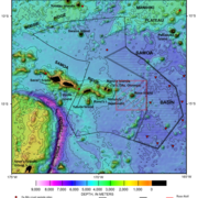
American Samoa Mapping Project
USGS scientists are leading a sampling effort to the Samoan Basin, offshore of American Samoa. This work is part of an interagency supported three-month hydrograph survey project led by NOAA and in partnership with BOEM.
Where Land Meets Sea: USGS Science for Resilient Coastal Habitats
USGS coastal science plays a critical role in supporting the effective, science-based management of coastal ecosystems, where the biodiversity of land and sea meet. It provides managers with the information they need to make sound decisions. Through cutting-edge research, predictive modeling, and decision-support tools, USGS empowers resource managers to make informed, science-based choices. From...
By
Ecosystems Mission Area, Land Management Research Program, California Water Science Center, Eastern Ecological Science Center, Forest and Rangeland Ecosystem Science Center, Lower Mississippi-Gulf Water Science Center, Pacific Coastal and Marine Science Center, Western Ecological Research Center (WERC), Western Fisheries Research Center, Western Geographic Science Center, Wetland and Aquatic Research Center