
A look into the USGS Pacific Coastal and Marine Science Center’s Marine Minerals Laboratory Suite.
Images
Total: 0
Settings
Total: 0
Explore our planet through photography and imagery, including climate change and water all the way back to the 1800s when the USGS was surveying the country by horse and buggy.
Filter Total Items: 21537

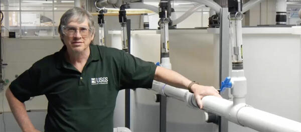
PCMSC Marine Minerals Laboratory
A look into the USGS Pacific Coastal and Marine Science Center’s Marine Minerals Laboratory Suite.

PCMSC Marine Minerals Laboratory
A look into the USGS Pacific Coastal and Marine Science Center’s Marine Minerals Laboratory Suite.
A look into the USGS Pacific Coastal and Marine Science Center’s Marine Minerals Laboratory Suite.

PCMSC Marine Minerals Laboratory
A look into the USGS Pacific Coastal and Marine Science Center’s Marine Minerals Laboratory Suite.
A look into the USGS Pacific Coastal and Marine Science Center’s Marine Minerals Laboratory Suite.

PCMSC Marine Minerals Laboratory
A look into the USGS Pacific Coastal and Marine Science Center’s Marine Minerals Laboratory Suite.
A look into the USGS Pacific Coastal and Marine Science Center’s Marine Minerals Laboratory Suite.

Permafrost in the National Petroleum Reserve-Alaska
Permafrost forms a grid-like pattern in the National Petroleum Reserve-Alaska, a 22.8 million acre region managed by the Bureau of Land Management on Alaska's North Slope. USGS has periodically assessed oil and gas resource potential there. These assessments can be found here.
Permafrost forms a grid-like pattern in the National Petroleum Reserve-Alaska, a 22.8 million acre region managed by the Bureau of Land Management on Alaska's North Slope. USGS has periodically assessed oil and gas resource potential there. These assessments can be found here.

Petis Bois model
A perspective model of the morphology and geologic framework near Petit Bois Island showing the relationships between seafloor features and the subsurface. The barrier islands rest on the island plaftorm. Petis Bois Pass and offshore shoals are clearly visible from the acoustic surveys. The bathymetry, sidescan sonar, and sediment
A perspective model of the morphology and geologic framework near Petit Bois Island showing the relationships between seafloor features and the subsurface. The barrier islands rest on the island plaftorm. Petis Bois Pass and offshore shoals are clearly visible from the acoustic surveys. The bathymetry, sidescan sonar, and sediment
Phil Sibrell
USGS inventor, Phil Sibrell, won 3rd place in the George Barley Water Prize competition in 2017, bringing home $10,000.00.
USGS inventor, Phil Sibrell, won 3rd place in the George Barley Water Prize competition in 2017, bringing home $10,000.00.

Photo of waves on the beach at Fire Island
Photo of waves on the beach at Fire Island
Photo of waves on the beach at Fire Island

Photograph of Bayou Heron, Mississippi
Photograph of moving-boat ADCP discharge measurements being made in Bayou Heron, Mississippi
Photograph of moving-boat ADCP discharge measurements being made in Bayou Heron, Mississippi

Phragmites rhizome
A Phragmites rhizome, or a belowground stem that puts up new shoots, dug up in a coastal marsh of Lake Erie in northern Ohio. Phragmites' belowground biomass can exceed that of its aboveground biomass.
A Phragmites rhizome, or a belowground stem that puts up new shoots, dug up in a coastal marsh of Lake Erie in northern Ohio. Phragmites' belowground biomass can exceed that of its aboveground biomass.

Phragmites, an invasive grass
Introduced Phragmites australis, also called the common reed, is an invasive grass in the Great Lakes.
Introduced Phragmites australis, also called the common reed, is an invasive grass in the Great Lakes.

Pilot and Crew Discussing Flight Plan for collecting AEM Data
Helicopter pilot and crew discussing flight plan and data collection before lifting off.
Helicopter pilot and crew discussing flight plan and data collection before lifting off.

Pollen samples from various plants collected from hedgerows
Organic Chemistry Research Laboratory -- Sacramento, California. Small sample bottles with pollen inside
Organic Chemistry Research Laboratory -- Sacramento, California. Small sample bottles with pollen inside

Pump hoist truck at Shavano Park at Fawn Drive
Back cover photo from

Quadcopter's photos can be used to measure dune erosion
The 3DR Solo with GoPro Hero4 camera and gimbal. Coming to a survey area near you soon. Photo credit: Shawn Harrison, USGS. This photo was taken during USGS unmanned aerial systems (drone) pilot training. Two training sessions were held - one in February-March 2017 in Santa Cruz, California and the second in April 2017 in Gainesville, Florida.
The 3DR Solo with GoPro Hero4 camera and gimbal. Coming to a survey area near you soon. Photo credit: Shawn Harrison, USGS. This photo was taken during USGS unmanned aerial systems (drone) pilot training. Two training sessions were held - one in February-March 2017 in Santa Cruz, California and the second in April 2017 in Gainesville, Florida.

R/V Muddy Waters
The R/V Muddy Waters lends itself to be a versatile survey launch and assistance vessel for the deployment and retrieval of inshore moorings and scientific sensor platforms. The boat can easily be towed to location by a full sized pickup truck and is easily launched and retrieved for fast mobilization after storm events or other rapid response surveys.
The R/V Muddy Waters lends itself to be a versatile survey launch and assistance vessel for the deployment and retrieval of inshore moorings and scientific sensor platforms. The boat can easily be towed to location by a full sized pickup truck and is easily launched and retrieved for fast mobilization after storm events or other rapid response surveys.

Rainbow Glacier perimeter: 1966, 1998, 2005, 2015.
This image shows the perimeter of Rainbow Glacier in Glacier National Park: 1966, 1998, 2005, 2015.
This image shows the perimeter of Rainbow Glacier in Glacier National Park: 1966, 1998, 2005, 2015.

Recovering Landscape Following Wildfire in High-Elevation Mojave
Photo of a high elevation community in the northern Mojave that had burned at high severity 27 years before the picture was taken. Note that the cover of shrubs and trees has not returned to preburn levels and invasive grasses (red brome and cheatgrass Bromus tectorum) are a significant component of the ground cover.
Photo of a high elevation community in the northern Mojave that had burned at high severity 27 years before the picture was taken. Note that the cover of shrubs and trees has not returned to preburn levels and invasive grasses (red brome and cheatgrass Bromus tectorum) are a significant component of the ground cover.

Reef core collected from Dry Tortugas National Park.
A reef core collected from Dry Tortugas National Park. Numbers indicate the depth of penetration into the reef in feet.
A reef core collected from Dry Tortugas National Park. Numbers indicate the depth of penetration into the reef in feet.

Research occurs at Fire Island environments, pictured
Photo collage of the shoreline, beaches, and dunes at Fire Island
Photo collage of the shoreline, beaches, and dunes at Fire Island

Researchers work on their video-camera station atop a hotel
Gerry Hatcher (left) and Shawn Harrison work on their video-camera station atop a hotel in Santa Cruz, California.
Gerry Hatcher (left) and Shawn Harrison work on their video-camera station atop a hotel in Santa Cruz, California.