
Surface activity continued in several small areas above the Kalapana access road, burning more vegetation in the forested kipuka. The trailhead to the county viewing area sits at the end of what remains of the access road, shown here at the top-middle portion of the photograph.
Images
Volcano Hazard Program images.
Filter Total Items: 6226

Lava Surface Activity
Surface activity continued in several small areas above the Kalapana access road, burning more vegetation in the forested kipuka. The trailhead to the county viewing area sits at the end of what remains of the access road, shown here at the top-middle portion of the photograph.

Lava Breakout
Breakouts continued near the County lava viewing trail. This breakout, which is burning a downed hala tree, was about 300 m west of the trailhead.
Breakouts continued near the County lava viewing trail. This breakout, which is burning a downed hala tree, was about 300 m west of the trailhead.

Waikupanaha ocean entry
One of the entry points, on the east side of the west Waikupanaha entry.
One of the entry points, on the east side of the west Waikupanaha entry.

Waikupanaha ocean entry
On the east margin of the entry, lobes were advancing over a small black sand beach.
On the east margin of the entry, lobes were advancing over a small black sand beach.

Halema'uma'u vent
Several collapses early this morning exposed more of the lava pond deep within the Halema`uma`u vent cavity. For the last several days, glowing and spattering holes (top image) have been active on the floor of the vent cavity, at a depth of about 200 m below the vent rim.
Several collapses early this morning exposed more of the lava pond deep within the Halema`uma`u vent cavity. For the last several days, glowing and spattering holes (top image) have been active on the floor of the vent cavity, at a depth of about 200 m below the vent rim.

Mount Baker's Carmelo Crater at the summit is breached by Roosevelt...
Mount Baker's Carmelo Crater at the summit is breached by Roosevelt Glacier, view to the southeast, Washington.
Mount Baker's Carmelo Crater at the summit is breached by Roosevelt Glacier, view to the southeast, Washington.

Helicopter Flight to Mount Redoubt
Scientists from the USGS Alaska Volcano Observatory (AVO) examine deposits on the lobe of the Drift Glacier with the summit of Mount Redoubt and its steaming lava dome in distance.
Scientists from the USGS Alaska Volcano Observatory (AVO) examine deposits on the lobe of the Drift Glacier with the summit of Mount Redoubt and its steaming lava dome in distance.
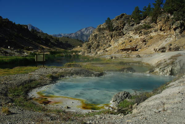
Bubbling Spring, a feature of Hot Creek in the Long Valley Caldera,...
Bubbling Spring, a feature of Hot Creek in the Long Valley Caldera, California, occasionally "boils" due to high water temperature.
Bubbling Spring, a feature of Hot Creek in the Long Valley Caldera, California, occasionally "boils" due to high water temperature.

Soil-temperature measurement at Hot Creek in Long Valley Caldera, CA.
Soil-temperature measurement at Hot Creek in Long Valley Caldera, California.
Soil-temperature measurement at Hot Creek in Long Valley Caldera, California.
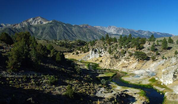
Hot Creek Gorge viewed upstream toward the SW; the steep walls of t...
Hot Creek Gorge viewed upstream toward the southwest; the steep walls of the gorge consist of a single rhyolite lava flow erupted from a vent 4 km (2.5 mi) to the south.
Hot Creek Gorge viewed upstream toward the southwest; the steep walls of the gorge consist of a single rhyolite lava flow erupted from a vent 4 km (2.5 mi) to the south.

Helicopter dropping off monitoring equipment at Mount St. Helens, WA.
Helicopter dropping off monitoring equipment at Mount St. Helens, Washington.
Helicopter dropping off monitoring equipment at Mount St. Helens, Washington.

Volcano monitoring spider helps scientists understand signs and sym...
The "spider" (a self-contained portable instrument package) was engineered and deployed during the 2004-2008 eruption of Mount St. Helens to detect and triangulate shallow earthquakes, monitor local ground deformation and uplift, detect lightning that might indicate an ash eruption and low frequency sound from explosions.
The "spider" (a self-contained portable instrument package) was engineered and deployed during the 2004-2008 eruption of Mount St. Helens to detect and triangulate shallow earthquakes, monitor local ground deformation and uplift, detect lightning that might indicate an ash eruption and low frequency sound from explosions.

View of the lava surface within the Overlook vent showing a crusted...
HVO geologists noted persistent spattering in the northeast corner of the lava lake within the Overlook vent during their night-time observations. The view of the lake surface was fairly good because of fume in the area of the Overlook was "thin" at the time.
HVO geologists noted persistent spattering in the northeast corner of the lava lake within the Overlook vent during their night-time observations. The view of the lake surface was fairly good because of fume in the area of the Overlook was "thin" at the time.

Scientist Captures thermal images of the Redoubt Lava Dome from Helicopter.
Kate Bull using a FLIR camera out the open door of an A-Star helicopter with the Redoubt summit and lava dome visible.
Kate Bull using a FLIR camera out the open door of an A-Star helicopter with the Redoubt summit and lava dome visible.

Early morning glow from Overlook vent in Halema‘uma‘u, Kīlauea
Incandescence from the lava lake surface (out of view) reflects an awesome glow on the gas plume rising from the lake surface.
Incandescence from the lava lake surface (out of view) reflects an awesome glow on the gas plume rising from the lake surface.

Mount Bachelor, OR viewed from the east.
Mount Bachelor, Oregon viewed from the east.
Mount Bachelor, Oregon viewed from the east.

Hydrothermal explosion at Biscuit Basin in YNP. These types of even...
Hydrothermal explosion at Biscuit Basin in Yellowstone National Park. These types of events are the most likely explosive hazard from the Yellowstone Volcano.
Hydrothermal explosion at Biscuit Basin in Yellowstone National Park. These types of events are the most likely explosive hazard from the Yellowstone Volcano.

HVO field crews collect temperature data on ground cracks in the Leilani Estates
HVO field crews collect temperature data on ground cracks in the Leilani Estates subdivision near the fissure complex. On this day, temperatures ranged from from 100 to 145 degrees C (200 to 300 degrees F), consistent with past readings.
HVO field crews collect temperature data on ground cracks in the Leilani Estates subdivision near the fissure complex. On this day, temperatures ranged from from 100 to 145 degrees C (200 to 300 degrees F), consistent with past readings.

Island of Hawai‘i from the Space Shuttle Atlantis in 2009 shows Kīl...
The summit plume from Halema‘uma‘u Crater (elevation 3,670 feet), hugs the southeast flank of Mauna Loa as it is blown by the northeasterly trade winds toward the southern point of the Island of Hawai‘i.
The summit plume from Halema‘uma‘u Crater (elevation 3,670 feet), hugs the southeast flank of Mauna Loa as it is blown by the northeasterly trade winds toward the southern point of the Island of Hawai‘i.

Lava Enters The Ocean At Kilauea Volcano, Hawai'i
Lava from the Pu'u 'Ō'ō-Kupaianaha eruption, active since 1983, enters the ocean on the south flank of Kīlauea Volcano.
Lava from the Pu'u 'Ō'ō-Kupaianaha eruption, active since 1983, enters the ocean on the south flank of Kīlauea Volcano.

Equipment Installation
Cyrus Read installing the new, zoomable web camera at the AVO research hut north of Redoubt Volcano.
Cyrus Read installing the new, zoomable web camera at the AVO research hut north of Redoubt Volcano.