
A small explosion in the early morning hours on April 16, 2008, from the new Halema‘uma‘u vent (below the white gas plume, left) blasted rock fragments less than 4 mm above the crater rim. Wind blew the ash plume southwest across Crater Rim Drive. Geologists' truck leaves tracks in the pale-red ash several millimeters thick on the roadway.
Images
Volcano Hazard Program images.
Filter Total Items: 6226

Volcanic ash covers Crater Rim Drive near Halema‘uma‘u
A small explosion in the early morning hours on April 16, 2008, from the new Halema‘uma‘u vent (below the white gas plume, left) blasted rock fragments less than 4 mm above the crater rim. Wind blew the ash plume southwest across Crater Rim Drive. Geologists' truck leaves tracks in the pale-red ash several millimeters thick on the roadway.

Geologist collects ash downwind of Halema‘uma‘u, Kīlauea
Ash and other lava fragments erupted from the new vent in HALE‘Ama‘uMAU Crater were collected almost daily from several wooden "tear catchers" located near the crater rim and from many more plastic buckets nearby. Six years later, ash collections are still made several times a week.
Ash and other lava fragments erupted from the new vent in HALE‘Ama‘uMAU Crater were collected almost daily from several wooden "tear catchers" located near the crater rim and from many more plastic buckets nearby. Six years later, ash collections are still made several times a week.

Trade winds blow gas plume from Halema‘uma‘u to SW, Kīlauea
Gas plume rising from the new Overlook Vent in Halema‘uma‘u Crater, Kīlauea Volcano, Hawai‘i. Trade winds blow the plume to the southwest.
Gas plume rising from the new Overlook Vent in Halema‘uma‘u Crater, Kīlauea Volcano, Hawai‘i. Trade winds blow the plume to the southwest.

Sulfur dioxide gas alert sign on Apr. 9, 2008 KILAUA
Road sign on Highway 11 warning drivers of high sulfur dioxide gas concentrations in the area from Kīlauea volcano. The temporary sign was put in place by Hawai‘i County Civil Defense, the agency responsible for public safety.
Road sign on Highway 11 warning drivers of high sulfur dioxide gas concentrations in the area from Kīlauea volcano. The temporary sign was put in place by Hawai‘i County Civil Defense, the agency responsible for public safety.

Advisory to drivers during high concentrations of sulfur dioxide ga...
Road sign on Highway 11 advises drivers to roll up windows to protect themselves from high sulfur dioxide gas concentrations Kīlauea volcano on April 9, 2008. The temporary sign was put in place by Hawai‘i County Civil Defense, the agency responsible for public safety.
Road sign on Highway 11 advises drivers to roll up windows to protect themselves from high sulfur dioxide gas concentrations Kīlauea volcano on April 9, 2008. The temporary sign was put in place by Hawai‘i County Civil Defense, the agency responsible for public safety.

Volcanic-gas plume rises from Halema‘uma‘u, Kīlauea
A plume of volcanic gases (chiefly water vapor, carbon dioxide, and sulfur dioxide), tiny lava and rock particles, and droplets drifts southwest in the tradewinds from Halema‘uma‘u Crater.
A plume of volcanic gases (chiefly water vapor, carbon dioxide, and sulfur dioxide), tiny lava and rock particles, and droplets drifts southwest in the tradewinds from Halema‘uma‘u Crater.

Ash-rich plume rises out of Halemaʻumaʻu Crater, Kilauea Volcano Hawaiʻi
Ash-rich plume rises out of Halemaʻumaʻu Crater, Kilauea Volcano Hawaiʻi.
Ash-rich plume rises out of Halemaʻumaʻu Crater, Kilauea Volcano Hawaiʻi.

Ash-rich plume rising from Halema‘uma‘u, Kīlauea 5 days after the f...
View of ash-rich plume rising from a new vent in Halema‘uma‘u Crater in Kīlauea Caldera 5 days after the first explosion from the vent occurred on March 19, 2008. The ash is turning the formerly white steam and gas plume a dusty-brown color. Note the ash fallout down-wind of the plume.
View of ash-rich plume rising from a new vent in Halema‘uma‘u Crater in Kīlauea Caldera 5 days after the first explosion from the vent occurred on March 19, 2008. The ash is turning the formerly white steam and gas plume a dusty-brown color. Note the ash fallout down-wind of the plume.

Wooden fence on edge of Halema‘uma‘u Overlook area damaged by explo...
The explosion occurred at 2:58 a.m. HST on March 19, 2008. The explosion scattered rock debris over an area of about 30 hectares (75 acres), covering a portion of Crater Rim Drive and damaging Halema‘uma‘u Overlook. The wooden fence of the overlook was bombarded by rocks hurled onto the rim of Halema‘uma‘u crater from the fumarolic area.
The explosion occurred at 2:58 a.m. HST on March 19, 2008. The explosion scattered rock debris over an area of about 30 hectares (75 acres), covering a portion of Crater Rim Drive and damaging Halema‘uma‘u Overlook. The wooden fence of the overlook was bombarded by rocks hurled onto the rim of Halema‘uma‘u crater from the fumarolic area.

Early morning view of fumarolic area at the base of eastern wall of...
This fumarolic area appeared on March 12, 2008. Gas is being emitted through rubble the Halema‘uma‘u Crater wall. The white fume is a mixture of condensed water vapor, sulfur trioxide, and invisible sulfur dioxide. The fume takes a pale bluish color if it contains very tiny sulfur particles (in center of fuming area).
This fumarolic area appeared on March 12, 2008. Gas is being emitted through rubble the Halema‘uma‘u Crater wall. The white fume is a mixture of condensed water vapor, sulfur trioxide, and invisible sulfur dioxide. The fume takes a pale bluish color if it contains very tiny sulfur particles (in center of fuming area).

Glass Mountain obsidian flow at Medicine Lake volcano, CA.
Glass Mountain obsidian flow at Medicine Lake volcano, California. Glass Mountain is a spectacular, nearly treeless, steep-sided rhyolite and dacite obsidian flow that erupted just outside the eastern caldera rim and flowed down the steep eastern flank of Medicine Lake volcano.
Glass Mountain obsidian flow at Medicine Lake volcano, California. Glass Mountain is a spectacular, nearly treeless, steep-sided rhyolite and dacite obsidian flow that erupted just outside the eastern caldera rim and flowed down the steep eastern flank of Medicine Lake volcano.

Stream of lava from Pu‘u ‘Ō‘ō flowing through the forest in the Roy...
Stream of lava from Pu‘u ‘Ō‘ō flowing through the forest in the Royal Gardens subdivision, February 28, 2008. The lava stream is about 3 m (10 ft) wide. Kīlauea Volcano, Hawai‘i.
Stream of lava from Pu‘u ‘Ō‘ō flowing through the forest in the Royal Gardens subdivision, February 28, 2008. The lava stream is about 3 m (10 ft) wide. Kīlauea Volcano, Hawai‘i.

HVO technicians working seismic station at summit of Kīlauea
HVO technicians install a solar-powered seismic station near the summit of Kīlauea Volcano to monitor earthquake activity. The seismic data is transmitted via radio signal directly to the observatory, where the data is initially analyzed by automatic computer programs and then examined in greater detail by a seismologist. Mauna Loa Volcano in background.
HVO technicians install a solar-powered seismic station near the summit of Kīlauea Volcano to monitor earthquake activity. The seismic data is transmitted via radio signal directly to the observatory, where the data is initially analyzed by automatic computer programs and then examined in greater detail by a seismologist. Mauna Loa Volcano in background.

Vog from Kilauea
The rim of Kīlauea Volcano’s summit caldera, normally clear on trade-wind days (left), became nearly obscured by vog (right) on some non-trade wind days beginning in 2008, when sulfur dioxide emissions from the volcano’s summit increased to unusually high levels. (This photo has been edited.)
The rim of Kīlauea Volcano’s summit caldera, normally clear on trade-wind days (left), became nearly obscured by vog (right) on some non-trade wind days beginning in 2008, when sulfur dioxide emissions from the volcano’s summit increased to unusually high levels. (This photo has been edited.)

South, Middle, and North Sister volcanoes,Three Sisters OR.
South, Middle, and North Sister volcanoes viewed aerially from the south, Three Sisters Oregon.
South, Middle, and North Sister volcanoes viewed aerially from the south, Three Sisters Oregon.

North Sister volcano's east face (750 m, 2460 ft high) consists of ...
East face of North Sister, 750 m high. Consists of about 100 thin mafic lava flows and intercalated layers of red scoria, capped by thick summit lava flows. Remnant of Thayer Glacier feeds cirque lake. Pervasively altered yellow-orange buttress on right, 250 m thick, consists of east-dipping, palagonitized, ash-rich fragmental flow deposits.
East face of North Sister, 750 m high. Consists of about 100 thin mafic lava flows and intercalated layers of red scoria, capped by thick summit lava flows. Remnant of Thayer Glacier feeds cirque lake. Pervasively altered yellow-orange buttress on right, 250 m thick, consists of east-dipping, palagonitized, ash-rich fragmental flow deposits.

South Sister volcano's northeast face with stacks of andesite lava flows and oxidized (red colored) scoria.
linkProuty Glacier headwall on the northeast face of South Sister. Dipping stacks of lava and scoria were excavated by Prouty Glacier, exposing cross-sectional views of the last 33,000 years of summit activity. The 350-m-thick (11,500-ft) lava stacks are truncated at about 3000 m (9,800 ft) elevation, forming the ragged rim of a broad paleocrater.

South Sister's northwest summit, basaltic andesite lava and scoria cap the volcano.
Lost Creek Glacier and its cirque are in the center, and Eugene Glacier and its cirque are toward the bottom left. Fingerlike lobes of dacite lava dribble down northwest ridge atop fragmental deposit and beneath capping agglutinate. The entire edifice visible here was built between 30 and 20 ka.
Lost Creek Glacier and its cirque are in the center, and Eugene Glacier and its cirque are toward the bottom left. Fingerlike lobes of dacite lava dribble down northwest ridge atop fragmental deposit and beneath capping agglutinate. The entire edifice visible here was built between 30 and 20 ka.

Broken Top volcano, inactive since 150 ka or longer, viewed to NW. ...
Radially dipping strata of the cone include subequal proportions of lava flows and flow breccias and of proximal agglutinate and scoria falls, nearly all having 54 to 56 percent SiO2. Numerous mafic dikes and sills intrude the cone, and an apron of compositionally similar mafic lavas extends far outward from the cone.
Radially dipping strata of the cone include subequal proportions of lava flows and flow breccias and of proximal agglutinate and scoria falls, nearly all having 54 to 56 percent SiO2. Numerous mafic dikes and sills intrude the cone, and an apron of compositionally similar mafic lavas extends far outward from the cone.

Hydrothermal system and water flow in the subsurface beneath Long V...
Hydrothermal system and water flow in the subsurface beneath Long Valley Caldera, California. Cartoon Illustration from USGS FS 2007-3045.
Hydrothermal system and water flow in the subsurface beneath Long Valley Caldera, California. Cartoon Illustration from USGS FS 2007-3045.
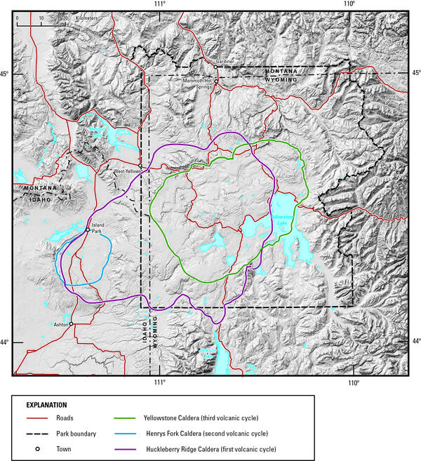
Digital elevation model of Yellowstone National Park and vicinity
Digital elevation model of Yellowstone National Park and vicinity, showing the location of the calderas formed during each of Yellowstone’s three most recent volcanic cycles. The youngest caldera-forming eruption produced Yellowstone Caldera (green line), located within Yellowstone National Park.
Digital elevation model of Yellowstone National Park and vicinity, showing the location of the calderas formed during each of Yellowstone’s three most recent volcanic cycles. The youngest caldera-forming eruption produced Yellowstone Caldera (green line), located within Yellowstone National Park.