


In the winter of 2015, the public noticed thousands of dead seabirds washing ashore across the western coast of the United States and Canada. The USGS linked this massive seabird die-off to the North Pacific Marine Heatwave. A marine heatwave occurs when sea surface temperatures are above normal for an extended period of time.
Marine Biology and Ecosystems
California Sea Otter Surveys and Research
Coral Reef Project
Aerial Seabird and Marine Mammal Surveys
Manatees
CASC Fish Research
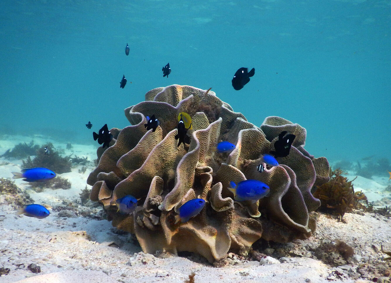
The ocean is home to a wealth of biodiversity - from invisible-to-the-eye microbes to the larger-than-life megafauna - and unique marine habitat, such as deepwater coral reefs, seamounts, and submarine canyons. USGS science helps inform the management and conservation of marine biodiversity and habitats, from the coastlines down to the deepest trench.
Life in the Sea
From the microscopic plants known as phytoplankton that form the basis of the aquatic food web to the largest animal to ever live on Earth, the blue whale, our oceans are home to a wealth of biodiversity and every organism plays a critical role in the structure and function of this expansive marine environment.


Sources/Usage: Public Domain. View Media Details
Maintaining this biodiversity is important because a healthy ocean provides us with oxygen, helps regulate climate and weather, acts as a source of protein for many people around the world, and provides jobs and opportunities for eco-tourism and recreation. USGS science informs the management and conservation of marine biodiversity and habitats, in both nearshore and deepwater ecosystems.
USGS Role in Marine Ecosystems Research
From the Atlantic to the Pacific and the Gulf of Mexico in between, USGS scientists have implemented a multi-faceted offshore research program that weaves together expertise in a variety of disciplines to investigate nearshore and deepwater ecosystems. This interdisciplinary approach relies on a network of partners from around the Nation and the world to examine microbiology, population genetics, paleoecology, food webs, taxonomy, community ecology, physical oceanography, seafloor characteristics, and submarine hazards in the little explored, yet vital, marine ecosystems.

Sources/Usage: Public Domain. View Media Details

Sources/Usage: Public Domain. View Media Details

Sources/Usage: Public Domain. View Media Details
USGS Science in Nearshore Ecosystems
Nearshore systems are the habitats in which most people interact with marine environments, which include seabirds, seagrasses, algae, benthic invertebrates and fish, and top predators that include marine mammals like sharks, sea otters, walruses, and even polar bears. USGS research addresses natural and human-induced changes to this ecosystem and all its components.

Sources/Usage: Public Domain. View Media Details
Exploring Deep-sea Ecosystems
Most life in the ocean exists in surface waters above 200 meters depth where they have access to sunlight. However, even below 200 meters, where little to no sunlight reaches, temperatures drop, and pressure increases, abundant life exists. A diversity of organisms, including fishes, crustaceans, cephalopods, anemones, sea stars, microbes, and even corals make their home in the deep sea. These organisms reside on topographically complex terrain mirroring our terrestrial landscape, dotted with features like trenches, seamounts, canyons, and volcanoes. They also leave behind fossils that help geoscientists construct models of ancient ocean conditions and Earth’s geologic history, as shown in the schematic below.

Sources/Usage: Public Domain. View Media Details
Life at the Bottom of the Ocean
The mention of the seafloor may evoke thoughts of a deep, dark expanse of nothing, but the often-assumed void of life in the deep sea couldn’t be further from the truth. Even with the lack of sunlight, an average temperature of 4 degrees Celsius, and extreme pressures that an unprotected human could not survive, the deep sea is brimming with biodiversity, including deep-sea corals. The DISCOVRE (DIversity, Systematics and COnnectivity of Vulnerable Reef Ecosystems) program investigates unique and fragile deep-sea coral environments from the microscopic level to the ecosystem level. The multi-disciplinary approach has enhanced our understanding of the structure and function of significant biological communities surrounding deep coral reefs off the United States’ coasts.

Sources/Usage: Public Domain. View Media Details
Science
California Sea Otter Surveys and Research
WERC collaborates with other research scientists to conduct annual population surveys of the southern sea otter -- a federally listed threatened species. In coordination with the California Department of Fish and Wildlife and other institutions, ongoing surveys and research continues to inform the southern sea otter recovery plan for the U.S. Fish and Wildlife Service, and contributes to our...
Walrus Research
The USGS Alaska Science Center conducts long-term research on the Pacific walrus to provide scientific information to Department of Interior management agencies and Alaska Native co-management partners. In addition, the USGS Pacific walrus research program collaborates with the U.S. Fish and Wildlife Service (USFWS) and the State of Alaska’s Department of Fish and Game and Alaska Native co...
North Pacific Pelagic Seabird Database
The North Pacific Pelagic Seabird Database (NPPSD) contains survey transect data designed and conducted by numerous partners primarily to census seabirds at sea. The NPPSD includes more than 486,000 transect segments and includes observations of over 20 million birds of 258 species collected over the span of 50 years (from 1973 to 2022).
Polar Bear Research
Polar bears ( Ursus maritimus ) are one of 4 marine mammal species managed by the U.S. Department of Interior. The USGS Alaska Science Center leads long–term research on polar bears to inform local, state, national and international policy makers regarding conservation of the species and its habitat. Our studies, ongoing since 1985, are focused on population dynamics, health and energetics...
Pacific Marine Heatwave
The USGS conducts research on marine wildlife, habitats, and ecosystem processes to provide science to inform our partners as they make decisions relative to species status, resource use, and human activities. These studies examine impacts of severe heatwaves on marine ecosystems of the North Pacific.
Multimedia

North Pacific Marine Heatwave
In the winter of 2015, the public noticed thousands of dead seabirds washing ashore across the western coast of the United States and Canada. The USGS linked this massive seabird die-off to the North Pacific Marine Heatwave. A marine heatwave occurs when sea surface temperatures are above normal for an extended period of time.

Argos Wildlife Tracking Common Eiders - animation
Illustrates where Common Eiders were tracked using Argos Wildlife Tracking.
Illustrates where Common Eiders were tracked using Argos Wildlife Tracking.

Seabirds and Marine Mammals Photographed During Aerial Surveys

Tufted Puffins on the water, Alaska
Four Tufted Puffins on the water, near their breeding colony at Gull Island in Kachemak Bay, Alaska
Four Tufted Puffins on the water, near their breeding colony at Gull Island in Kachemak Bay, Alaska

Fin Whale (Balaenoptera physalus) breaking the surface
Zoomed image of a Fin Whale (Balaenoptera physalus) breaking the surface.
Zoomed image of a Fin Whale (Balaenoptera physalus) breaking the surface.

Argos Wildlife Tracking Pelagic Cormorants - animation
Illustrates where Pelagic Cormorants were tracked using Argos Wildlife Tracking.
Illustrates where Pelagic Cormorants were tracked using Argos Wildlife Tracking.

Argos Wildlife Tracking Tufted Puffin animation
Illustrates where Tufted Puffins were tracked using Argos Wildlife Tracking
Illustrates where Tufted Puffins were tracked using Argos Wildlife Tracking

Argos Wildlife Tracking Northern Fulmar animation
Illustrates where Northern Fulmars were tracked using Argos Wildlife Tracking.
Illustrates where Northern Fulmars were tracked using Argos Wildlife Tracking.

Timing is Everything: Fish, Wildlife, and Timing of Life Events
Timing is Everything: How Fish and Wildlife are Responding to Climate Change Through Shifts in the Timing of Life Events
Timing is Everything: How Fish and Wildlife are Responding to Climate Change Through Shifts in the Timing of Life Events
Filter Total Items: 42

Seabird Vulnerability Assessment for Renewable Energy Projects
In 2017, the Western Ecological Research Center's seabird studies team developed a framework for quantifying seabird species vulnerability to offshore wind energy infrastructure in the Pacific Outer Continental Shelf portion of the California Current region. This tool supports marine resource-use planning by identifying sites where seabirds are most vulnerable and predicts how different species...

Aerial Seabird and Marine Mammal Surveys
The Seabird Studies Team at the USGS Western Ecological Research Center is conducting aerial photographic surveys of the ocean off central and southern California to create comprehensive maps of seabird and marine mammal distributions. The project is supported by the Bureau of Ocean Energy Management and will inform planning in advance of potential offshore wind energy development along the...

Controls on Habitat for Native Lampreys in the Umpqua River Basin
Native lampreys are culturally significant fishes for tribal communities in Oregon. As such, the USGS has begun working with the Cow Creek Band of Umpqua Tribe of Indians to study changes that may be affecting habitat for native Pacific and western brook lampreys in the Umpqua River basin.

Controls on Salmon and Lamprey Habitat along the Siletz River
Chinook Salmon and Pacific Lamprey are culturally significant fishes to the Tribal community along the Siletz River, Oregon. The USGS has begun studying how streamflow and bedload conditions may influence mainstem spawning habitats.

Sea Turtle Movement and Habitat Use in the Northern Gulf of Mexico
The Bureau of Ocean Energy Management (BOEM) uses trawling to capture and relocate live sea turtles away from dredging locations to minimize the risk of turtle entrainment. These incidental turtle captures provide a unique opportunity to fill critical data gaps for difficult to capture life-stages of marine turtles.

Snake River Fall Chinook Salmon Research
Snake River fall Chinook salmon were listed as “threatened” under the Endangered Species Act in 1992. At that time, little was known about the spawning, rearing, migration, and life history of this species. This long-term research and monitoring project has produced much of the contemporary knowledge on fall Chinook salmon that has been used by fish managers to implement recovery measures. The...

Marine Invertebrate Diseases
Coral reefs worldwide are under tremendous stress primarily due to human activities along the coasts. While climate change, over fishing, and coastal development have been implicated as a major cause of coral reef decline, diseases seem to play an increasing role.

Avian Ecology and Multi-Species Habitat Use in Pacific Coast Estuaries
Waterbirds such as shorebirds, waders, and ducks depend on healthy and productive estuaries to “fuel up” for long distance migrations along the Pacific Flyway. Estuarine ecosystems include a mosaic of managed, natural, and restoring wetlands , and provide critical stop-over and wintering areas for federally protected migratory bird species. USGS WERC’s Dr. Susan De La Cruz works with federal...

Seabird Ecology and Marine Planning
Seabirds are Department of the Interior (DOI) Trust Species and are protected under the Migratory Bird Treaty Act and the Endangered Species Act. To support science-based decision capacity and Marine Spatial Planning (MSP) among U.S. Government resource managers, Dr. Josh Adams and the WERC seabird team have partnered with the Bureau of Ocean Energy Management, U.S. Fish and Wildlife Service...

Seabird Health and Adaptive Management
Dr. Josh Adams and his science team at WERC study seabird health and support adaptive management by quantifying abundance patterns and behaviors associated with habitats at sea, where seabirds spend the overwhelming majority of their lives. Adams’s team also employs conservation science to support resource managers on land, where seabirds are obligated to nest. His group provides scientific...

Invasive Mussel Control Science: Management Tools for Assessing the Risks and Control of Invasive Dreissenid Species
Invasive zebra and quagga mussels ( Dreissena polymorpha and D. rostriformis bugensis , respectively) are causing significant ecological and economic impacts and the scope of these impacts increases as they continue to spread across North America. The USGS conducts science to inform management actions for controlling and mitigating the impacts of invasive mussels. Studies include evaluation and...

Santa Cruz Field Station
Scientists at the Santa Cruz Field Station study sea otters and seabirds in their environment. The USGS Western Ecological Research Center has two research missions based in the Santa Cruz region:
The ocean is home to a wealth of biodiversity - from invisible-to-the-eye microbes to the larger-than-life megafauna - and unique marine habitat, such as deepwater coral reefs, seamounts, and submarine canyons. USGS science helps inform the management and conservation of marine biodiversity and habitats, from the coastlines down to the deepest trench.
Life in the Sea
From the microscopic plants known as phytoplankton that form the basis of the aquatic food web to the largest animal to ever live on Earth, the blue whale, our oceans are home to a wealth of biodiversity and every organism plays a critical role in the structure and function of this expansive marine environment.
Sources/Usage: Public Domain. View Media Details
Maintaining this biodiversity is important because a healthy ocean provides us with oxygen, helps regulate climate and weather, acts as a source of protein for many people around the world, and provides jobs and opportunities for eco-tourism and recreation. USGS science informs the management and conservation of marine biodiversity and habitats, in both nearshore and deepwater ecosystems.
USGS Role in Marine Ecosystems Research
From the Atlantic to the Pacific and the Gulf of Mexico in between, USGS scientists have implemented a multi-faceted offshore research program that weaves together expertise in a variety of disciplines to investigate nearshore and deepwater ecosystems. This interdisciplinary approach relies on a network of partners from around the Nation and the world to examine microbiology, population genetics, paleoecology, food webs, taxonomy, community ecology, physical oceanography, seafloor characteristics, and submarine hazards in the little explored, yet vital, marine ecosystems.
Sources/Usage: Public Domain. View Media Details
Sources/Usage: Public Domain. View Media Details
Sources/Usage: Public Domain. View Media Details
USGS Science in Nearshore Ecosystems
Nearshore systems are the habitats in which most people interact with marine environments, which include seabirds, seagrasses, algae, benthic invertebrates and fish, and top predators that include marine mammals like sharks, sea otters, walruses, and even polar bears. USGS research addresses natural and human-induced changes to this ecosystem and all its components.
Sources/Usage: Public Domain. View Media Details
Exploring Deep-sea Ecosystems
Most life in the ocean exists in surface waters above 200 meters depth where they have access to sunlight. However, even below 200 meters, where little to no sunlight reaches, temperatures drop, and pressure increases, abundant life exists. A diversity of organisms, including fishes, crustaceans, cephalopods, anemones, sea stars, microbes, and even corals make their home in the deep sea. These organisms reside on topographically complex terrain mirroring our terrestrial landscape, dotted with features like trenches, seamounts, canyons, and volcanoes. They also leave behind fossils that help geoscientists construct models of ancient ocean conditions and Earth’s geologic history, as shown in the schematic below.
Sources/Usage: Public Domain. View Media Details
Life at the Bottom of the Ocean
The mention of the seafloor may evoke thoughts of a deep, dark expanse of nothing, but the often-assumed void of life in the deep sea couldn’t be further from the truth. Even with the lack of sunlight, an average temperature of 4 degrees Celsius, and extreme pressures that an unprotected human could not survive, the deep sea is brimming with biodiversity, including deep-sea corals. The DISCOVRE (DIversity, Systematics and COnnectivity of Vulnerable Reef Ecosystems) program investigates unique and fragile deep-sea coral environments from the microscopic level to the ecosystem level. The multi-disciplinary approach has enhanced our understanding of the structure and function of significant biological communities surrounding deep coral reefs off the United States’ coasts.
Sources/Usage: Public Domain. View Media Details
Science
California Sea Otter Surveys and Research
WERC collaborates with other research scientists to conduct annual population surveys of the southern sea otter -- a federally listed threatened species. In coordination with the California Department of Fish and Wildlife and other institutions, ongoing surveys and research continues to inform the southern sea otter recovery plan for the U.S. Fish and Wildlife Service, and contributes to our...
Walrus Research
The USGS Alaska Science Center conducts long-term research on the Pacific walrus to provide scientific information to Department of Interior management agencies and Alaska Native co-management partners. In addition, the USGS Pacific walrus research program collaborates with the U.S. Fish and Wildlife Service (USFWS) and the State of Alaska’s Department of Fish and Game and Alaska Native co...
North Pacific Pelagic Seabird Database
The North Pacific Pelagic Seabird Database (NPPSD) contains survey transect data designed and conducted by numerous partners primarily to census seabirds at sea. The NPPSD includes more than 486,000 transect segments and includes observations of over 20 million birds of 258 species collected over the span of 50 years (from 1973 to 2022).
Polar Bear Research
Polar bears ( Ursus maritimus ) are one of 4 marine mammal species managed by the U.S. Department of Interior. The USGS Alaska Science Center leads long–term research on polar bears to inform local, state, national and international policy makers regarding conservation of the species and its habitat. Our studies, ongoing since 1985, are focused on population dynamics, health and energetics...
Pacific Marine Heatwave
The USGS conducts research on marine wildlife, habitats, and ecosystem processes to provide science to inform our partners as they make decisions relative to species status, resource use, and human activities. These studies examine impacts of severe heatwaves on marine ecosystems of the North Pacific.
Multimedia
North Pacific Marine Heatwave
In the winter of 2015, the public noticed thousands of dead seabirds washing ashore across the western coast of the United States and Canada. The USGS linked this massive seabird die-off to the North Pacific Marine Heatwave. A marine heatwave occurs when sea surface temperatures are above normal for an extended period of time.
In the winter of 2015, the public noticed thousands of dead seabirds washing ashore across the western coast of the United States and Canada. The USGS linked this massive seabird die-off to the North Pacific Marine Heatwave. A marine heatwave occurs when sea surface temperatures are above normal for an extended period of time.
Argos Wildlife Tracking Common Eiders - animation
Illustrates where Common Eiders were tracked using Argos Wildlife Tracking.
Illustrates where Common Eiders were tracked using Argos Wildlife Tracking.
Seabirds and Marine Mammals Photographed During Aerial Surveys
Tufted Puffins on the water, Alaska
Four Tufted Puffins on the water, near their breeding colony at Gull Island in Kachemak Bay, Alaska
Four Tufted Puffins on the water, near their breeding colony at Gull Island in Kachemak Bay, Alaska
Fin Whale (Balaenoptera physalus) breaking the surface
Zoomed image of a Fin Whale (Balaenoptera physalus) breaking the surface.
Zoomed image of a Fin Whale (Balaenoptera physalus) breaking the surface.
Argos Wildlife Tracking Pelagic Cormorants - animation
Illustrates where Pelagic Cormorants were tracked using Argos Wildlife Tracking.
Illustrates where Pelagic Cormorants were tracked using Argos Wildlife Tracking.
Argos Wildlife Tracking Tufted Puffin animation
Illustrates where Tufted Puffins were tracked using Argos Wildlife Tracking
Illustrates where Tufted Puffins were tracked using Argos Wildlife Tracking
Argos Wildlife Tracking Northern Fulmar animation
Illustrates where Northern Fulmars were tracked using Argos Wildlife Tracking.
Illustrates where Northern Fulmars were tracked using Argos Wildlife Tracking.
Timing is Everything: Fish, Wildlife, and Timing of Life Events
Timing is Everything: How Fish and Wildlife are Responding to Climate Change Through Shifts in the Timing of Life Events
Timing is Everything: How Fish and Wildlife are Responding to Climate Change Through Shifts in the Timing of Life Events
Filter Total Items: 42
Seabird Vulnerability Assessment for Renewable Energy Projects
In 2017, the Western Ecological Research Center's seabird studies team developed a framework for quantifying seabird species vulnerability to offshore wind energy infrastructure in the Pacific Outer Continental Shelf portion of the California Current region. This tool supports marine resource-use planning by identifying sites where seabirds are most vulnerable and predicts how different species...
Aerial Seabird and Marine Mammal Surveys
The Seabird Studies Team at the USGS Western Ecological Research Center is conducting aerial photographic surveys of the ocean off central and southern California to create comprehensive maps of seabird and marine mammal distributions. The project is supported by the Bureau of Ocean Energy Management and will inform planning in advance of potential offshore wind energy development along the...
Controls on Habitat for Native Lampreys in the Umpqua River Basin
Native lampreys are culturally significant fishes for tribal communities in Oregon. As such, the USGS has begun working with the Cow Creek Band of Umpqua Tribe of Indians to study changes that may be affecting habitat for native Pacific and western brook lampreys in the Umpqua River basin.
Controls on Salmon and Lamprey Habitat along the Siletz River
Chinook Salmon and Pacific Lamprey are culturally significant fishes to the Tribal community along the Siletz River, Oregon. The USGS has begun studying how streamflow and bedload conditions may influence mainstem spawning habitats.
Sea Turtle Movement and Habitat Use in the Northern Gulf of Mexico
The Bureau of Ocean Energy Management (BOEM) uses trawling to capture and relocate live sea turtles away from dredging locations to minimize the risk of turtle entrainment. These incidental turtle captures provide a unique opportunity to fill critical data gaps for difficult to capture life-stages of marine turtles.
Snake River Fall Chinook Salmon Research
Snake River fall Chinook salmon were listed as “threatened” under the Endangered Species Act in 1992. At that time, little was known about the spawning, rearing, migration, and life history of this species. This long-term research and monitoring project has produced much of the contemporary knowledge on fall Chinook salmon that has been used by fish managers to implement recovery measures. The...
Marine Invertebrate Diseases
Coral reefs worldwide are under tremendous stress primarily due to human activities along the coasts. While climate change, over fishing, and coastal development have been implicated as a major cause of coral reef decline, diseases seem to play an increasing role.
Avian Ecology and Multi-Species Habitat Use in Pacific Coast Estuaries
Waterbirds such as shorebirds, waders, and ducks depend on healthy and productive estuaries to “fuel up” for long distance migrations along the Pacific Flyway. Estuarine ecosystems include a mosaic of managed, natural, and restoring wetlands , and provide critical stop-over and wintering areas for federally protected migratory bird species. USGS WERC’s Dr. Susan De La Cruz works with federal...
Seabird Ecology and Marine Planning
Seabirds are Department of the Interior (DOI) Trust Species and are protected under the Migratory Bird Treaty Act and the Endangered Species Act. To support science-based decision capacity and Marine Spatial Planning (MSP) among U.S. Government resource managers, Dr. Josh Adams and the WERC seabird team have partnered with the Bureau of Ocean Energy Management, U.S. Fish and Wildlife Service...
Seabird Health and Adaptive Management
Dr. Josh Adams and his science team at WERC study seabird health and support adaptive management by quantifying abundance patterns and behaviors associated with habitats at sea, where seabirds spend the overwhelming majority of their lives. Adams’s team also employs conservation science to support resource managers on land, where seabirds are obligated to nest. His group provides scientific...
Invasive Mussel Control Science: Management Tools for Assessing the Risks and Control of Invasive Dreissenid Species
Invasive zebra and quagga mussels ( Dreissena polymorpha and D. rostriformis bugensis , respectively) are causing significant ecological and economic impacts and the scope of these impacts increases as they continue to spread across North America. The USGS conducts science to inform management actions for controlling and mitigating the impacts of invasive mussels. Studies include evaluation and...
Santa Cruz Field Station
Scientists at the Santa Cruz Field Station study sea otters and seabirds in their environment. The USGS Western Ecological Research Center has two research missions based in the Santa Cruz region: