
Hurricane tracks for Hugo (1989), Georges (1998), Irma (2017) and Maria (2017). Data provided by NOAA. Base image is intellectual property of Esri and is used herein under license. Copyright Esri and its creator.
Images
We conduct a wide range of science that improves our understanding and ability to forecast, prepare for and respond to natural hazards. Find images that illustrate this work along with the threats, risks and impacts these hazards pose.

Hurricane Tracks, Puerto Rico
Hurricane tracks for Hugo (1989), Georges (1998), Irma (2017) and Maria (2017). Data provided by NOAA. Base image is intellectual property of Esri and is used herein under license. Copyright Esri and its creator.

Debris flow after the 2003 Old Gran Prix fire
Damage from a major post-wildfire landslide that occurred on 25 December 2003 near Devore, San Bernardino County as a result of the Old/Grand Prix fires that ran through the San Bernardino Mountains.
Damage from a major post-wildfire landslide that occurred on 25 December 2003 near Devore, San Bernardino County as a result of the Old/Grand Prix fires that ran through the San Bernardino Mountains.

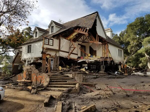
Home damaged by post-wildfire debris flow in Montecito, CA.
Damage from a major post-wildfire landslide that occurred on 9 January 2018 near Montecito, Santa Barbara County as a result of the 2017 Thomas Fire.
Damage from a major post-wildfire landslide that occurred on 9 January 2018 near Montecito, Santa Barbara County as a result of the 2017 Thomas Fire.

USGS and NBRO Scientists in Sri Lanka
USGS scientists collaborate with Sri Lankan scientists from the National Building Research Organization (NBRO) on the installation of rainfall and soil moisture instrumentation on an active landslide in southwest Sri Lanka. The station provides real-time data including rainfall and soil moisture content of an active landslide.
USGS scientists collaborate with Sri Lankan scientists from the National Building Research Organization (NBRO) on the installation of rainfall and soil moisture instrumentation on an active landslide in southwest Sri Lanka. The station provides real-time data including rainfall and soil moisture content of an active landslide.

Montecito home damaged by post-wildfire debrisflow.
Damage from a major post-wildfire landslide that occurred on 9 January 2018 near Montecito, Santa Barbara County as a result of the 2017 Thomas Fire.
Damage from a major post-wildfire landslide that occurred on 9 January 2018 near Montecito, Santa Barbara County as a result of the 2017 Thomas Fire.