
The inside of a borehole seismometer equipment enclosure is full of batteries, cables, data communications equipment and data recording instruments. Some of the geodetic infrastructure in Yellowstone National Park is colocated with seismic equipment. In this case, the communications downlink radio for the GNSS station is housed with the borehole enc
Images
Images of Yellowstone.
Filter Total Items: 532

The inside of a Yellowstone borehole seismometer equipment enclosure
The inside of a borehole seismometer equipment enclosure is full of batteries, cables, data communications equipment and data recording instruments. Some of the geodetic infrastructure in Yellowstone National Park is colocated with seismic equipment. In this case, the communications downlink radio for the GNSS station is housed with the borehole enc

View of Absaroka Range from Eagle Peak, WY, toward the southwest
View of Absaroka Range from Eagle Peak, WY, toward the southwest.
View of Absaroka Range from Eagle Peak, WY, toward the southwest.

Upper Geyser Basin viewed from the Old Faithful webcam
The Upper Geyser Basin viewed from the Old Faithful webcam. Hot water was piped from Solitary Geyser to the former site of the geyser bathhouse.
The Upper Geyser Basin viewed from the Old Faithful webcam. Hot water was piped from Solitary Geyser to the former site of the geyser bathhouse.

Map of thermal areas and lakes in Yellowstone National Park
Map of thermal areas in Yellowstone (red), as well as lakes (outlined in blue), many of which have thermal areas on their shores or beneath their surfaces.
Map of thermal areas in Yellowstone (red), as well as lakes (outlined in blue), many of which have thermal areas on their shores or beneath their surfaces.

Fern Lake, Yellowstone National Park, in different seasons
High-resolution images of Fern Lake from different seasons. North is up. Fern Lake is about 1 km across from east to west. Red arrows in the winter image point to large zones of open water, indicating either nearshore springs or underwater hydrothermal vents, but there are also many smaller zones of open water that are conspicuous.
High-resolution images of Fern Lake from different seasons. North is up. Fern Lake is about 1 km across from east to west. Red arrows in the winter image point to large zones of open water, indicating either nearshore springs or underwater hydrothermal vents, but there are also many smaller zones of open water that are conspicuous.

Map showing subtle terraces on the north side of Yellowstone Lake
Shaded relief map based on high-resolution topographic data from lidar and showing subtle terraces on the north side of Yellowstone Lake (a few example terraces are marked by yellow arrows and traced by dashed and dotted white lines).
Shaded relief map based on high-resolution topographic data from lidar and showing subtle terraces on the north side of Yellowstone Lake (a few example terraces are marked by yellow arrows and traced by dashed and dotted white lines).

Map of geodetic infrastructure located in Yellowstone National Park
The UNAVCO-operated geodetic infrastructure located in Yellowstone National Park consists of over a dozen continuously operating geodetic sites. Most of these sites stream real-time data to the UNAVCO data center. After the September 2020 maintenance trip, there are now 8 fully upgraded GNSS sites (red square) located in the park.
The UNAVCO-operated geodetic infrastructure located in Yellowstone National Park consists of over a dozen continuously operating geodetic sites. Most of these sites stream real-time data to the UNAVCO data center. After the September 2020 maintenance trip, there are now 8 fully upgraded GNSS sites (red square) located in the park.

Thin section of lava sample from Yellowstone
Thin section made by slicing a small layer off the surface of a hand sample of Yeloowstone lava. Note the marker for scale.
Thin section made by slicing a small layer off the surface of a hand sample of Yeloowstone lava. Note the marker for scale.

Giantess Geyser in eruption on August 26, 2020
Giantess Geyser in eruption at approximately 10:00 AM MDT on August 26, 2020. Old Faithful is erupting in the center background.
Giantess Geyser in eruption at approximately 10:00 AM MDT on August 26, 2020. Old Faithful is erupting in the center background.

Example of a boundary problem in the Yellowstone geologic map
An example of a boundary iproblem n the Yellowstone National Park geologic map, which was stitched together from many smaller mapped sections. The red line highlights the contacts that contain different units across the boundary.
An example of a boundary iproblem n the Yellowstone National Park geologic map, which was stitched together from many smaller mapped sections. The red line highlights the contacts that contain different units across the boundary.

Tree rings in a Rocky Mountain Juniper, Yellowstone National Park
A scanned image of Rocky Mountain juniper deadwood sample GGR100 collected in the northern part of Yellowstone National Park under permit YELL-5582. The full length of this sample covers the time period 723-1792 CE.
A scanned image of Rocky Mountain juniper deadwood sample GGR100 collected in the northern part of Yellowstone National Park under permit YELL-5582. The full length of this sample covers the time period 723-1792 CE.

Photo looking north from the north shore of Yellowstone Lake
Photo looking north from the north shore of Yellowstone Lake. The photo was taken from a level bench, or terrace, which marks a previous high stand of the lake. In the middle distance (between the two red lines), the ground slopes up to second, higher-level terrace that indicates an even higher past lake level.
Photo looking north from the north shore of Yellowstone Lake. The photo was taken from a level bench, or terrace, which marks a previous high stand of the lake. In the middle distance (between the two red lines), the ground slopes up to second, higher-level terrace that indicates an even higher past lake level.

SNIF multi-GAS station on Mount St. Helens, Washington
USGS scientist Laura Clor performing maintenance on the SNIF multi-GAS station on Mount St. Helens, Washington.
USGS scientist Laura Clor performing maintenance on the SNIF multi-GAS station on Mount St. Helens, Washington.

interior of SNIF multi-GAS enclosure on Mount St. Helens, Washington
Interior of the SNIF multi-GAS enclosure on Mount St. Helens, Washington
Interior of the SNIF multi-GAS enclosure on Mount St. Helens, Washington
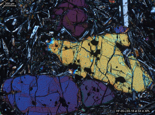
Thin section image of a lava sample from Yellowstone
Thin section image of a lava sample from Yellowstone using a polarizing microscope. The mineral assemblage is representative of many of Yellowstone’s basaltic rocks. The three large and colored crystals (known as phenocrysts) in the center of the image are the mineral olivine.
Thin section image of a lava sample from Yellowstone using a polarizing microscope. The mineral assemblage is representative of many of Yellowstone’s basaltic rocks. The three large and colored crystals (known as phenocrysts) in the center of the image are the mineral olivine.

Using a rangefinder to determine the height of Steamboat Geyser
In the first few minutes of Steamboat's eruptions, it has often been measured well over 300 ft. with a few exceptional eruptions measured by visitors at over 400 ft.! In this example, done using a rangefinder by a Yellowstone National Park ranger, it comes in at 334.9 ft. For comparison, the Lower Falls of the Yellowstone is about 308 ft.
In the first few minutes of Steamboat's eruptions, it has often been measured well over 300 ft. with a few exceptional eruptions measured by visitors at over 400 ft.! In this example, done using a rangefinder by a Yellowstone National Park ranger, it comes in at 334.9 ft. For comparison, the Lower Falls of the Yellowstone is about 308 ft.

NPS scientist collects imagery of Castle Geyser, Yellowstone
National Park Service scientist using a camera paired with a GPS receiver to obtain images of Castle Geyser, Yellowstone National Park, in June 2019.
National Park Service scientist using a camera paired with a GPS receiver to obtain images of Castle Geyser, Yellowstone National Park, in June 2019.

Sapphire Pool, Yellowstone National Park
Sapphire Pool, in Biscuit Basin, steams on a stormy morning. A few “biscuits” remain along the pool’s southern edge (center right of photo) – violent geyser eruptions destroyed hundreds of the features when the pool’s plumbing system changed after being jarred by the 1959 Hebgen Lake earthquake. National Park Service photo by Jacob W. Frank, July 20, 2020.
Sapphire Pool, in Biscuit Basin, steams on a stormy morning. A few “biscuits” remain along the pool’s southern edge (center right of photo) – violent geyser eruptions destroyed hundreds of the features when the pool’s plumbing system changed after being jarred by the 1959 Hebgen Lake earthquake. National Park Service photo by Jacob W. Frank, July 20, 2020.

Comet NEOWISE and the Roosevelt Arch at Yellowstone National Park
Comet NEOWISE is seen with the Roosevelt Arch in the foreground at the north Entrance of Yellowstone National Park. The town of Gardiner, Montana, is in the background.
Comet NEOWISE is seen with the Roosevelt Arch in the foreground at the north Entrance of Yellowstone National Park. The town of Gardiner, Montana, is in the background.

Panorama of Hayden Valley, Yellowstone National Park
Panoramic photo of Hayden Valley looking east toward the Yellowstone River from the Mary Mountain trail.
Panoramic photo of Hayden Valley looking east toward the Yellowstone River from the Mary Mountain trail.

Violet Creek in Hayden Valley, Yellowstone National Park
A small stream, Violet Creek, winds its way through Hayden Valley in Yellowstone National Park.
A small stream, Violet Creek, winds its way through Hayden Valley in Yellowstone National Park.