
Color-shaded topographic relief map of the Yellowstone Plateau-Snake River Plain volcanic province showing the track of the Yellowstone hot spot.
Images
Images of Yellowstone.
Filter Total Items: 628

Color-shaded topographic relief map of Yellowstone Plateau Snake River
Color-shaded topographic relief map of the Yellowstone Plateau-Snake River Plain volcanic province showing the track of the Yellowstone hot spot.

Map panels showing the distribution of caldera-forming tuff Yellowston
Map panels showing the distribution of major caldera-forming ash-flow deposits from the three major caldera-forming eruptions on the Yellowstone Plateau Volcanic Field. Updated from Christiansen, 2001 (USGS PP 729-G) with new age information.
Map panels showing the distribution of major caldera-forming ash-flow deposits from the three major caldera-forming eruptions on the Yellowstone Plateau Volcanic Field. Updated from Christiansen, 2001 (USGS PP 729-G) with new age information.

Maps of evolution stages of recent volcanism in Yellowstone Caldera
Maps displaying the stages of evolution of the more recent cycle of volcanism associated with Yellowstone Caldera. From Finn and Morgan, 2002 (High-resolution aeromagnetic mapping of volcanic terrain, Yellowstone National Park).
Maps displaying the stages of evolution of the more recent cycle of volcanism associated with Yellowstone Caldera. From Finn and Morgan, 2002 (High-resolution aeromagnetic mapping of volcanic terrain, Yellowstone National Park).

Box diagram and map showing sources and fate of geothermal solutes in the Yellowstone River
The Yellowstone River is divided into five reaches (labeled and color-coded): Yellowstone Lake, Hayden Valley, Grand Canyon of the Yellowstone, Tower–Gardner, and Mammoth. Monitoring stations (yellow dots on map) between each reach of the river reaches allow geochemists to measure river composition and then determine the sources of chloride (Cl) and other solu
The Yellowstone River is divided into five reaches (labeled and color-coded): Yellowstone Lake, Hayden Valley, Grand Canyon of the Yellowstone, Tower–Gardner, and Mammoth. Monitoring stations (yellow dots on map) between each reach of the river reaches allow geochemists to measure river composition and then determine the sources of chloride (Cl) and other solu

Summary geologic record of the Huckleberry Ridge Tuff eruption
Summary diagram of the geological record and timing of the Huckleberry Ridge Tuff eruption. See Swallow et al. (2019) for more details.
Summary diagram of the geological record and timing of the Huckleberry Ridge Tuff eruption. See Swallow et al. (2019) for more details.

Sapphire Pool, in the Biscuit Basin area of the Upper Geyser Basin, Yellowstone National Park
Sapphire Pool, an alkaline (pH ~7.5) spring in the Biscuit Basin area of the Upper Geyser Basin, Yellowstone National Park.
Sapphire Pool, an alkaline (pH ~7.5) spring in the Biscuit Basin area of the Upper Geyser Basin, Yellowstone National Park.
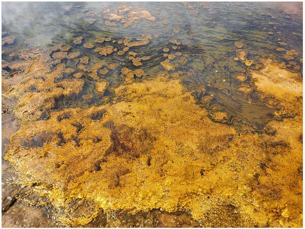
Alkaline hot spring outflow channel in the Biscuit Basin
A wide array of phototrophic microbial community textures exhibited in an alkaline (pH ~8.5) hot spring outflow channel in the Biscuit Basin, including thick mats, toadstools, ropes, and pinnacles. The differences in color are due to pigments (chlorophylls, bacteriochlorophylls, and carotenoids) produced by phototrophic microorganisms.
A wide array of phototrophic microbial community textures exhibited in an alkaline (pH ~8.5) hot spring outflow channel in the Biscuit Basin, including thick mats, toadstools, ropes, and pinnacles. The differences in color are due to pigments (chlorophylls, bacteriochlorophylls, and carotenoids) produced by phototrophic microorganisms.

Small acidic hot spring in the Gibbon Geyser Basin of Yellowstone National Park
An unnamed small acidic (pH ~3) hot spring (with a temperature of about 55°C at the source) in the Gibbon Geyser Basin of Yellowstone National Park. The yellow region is due to the precipitation of sulfur by sulfide-oxidizing chemotrophic microorganisms.
An unnamed small acidic (pH ~3) hot spring (with a temperature of about 55°C at the source) in the Gibbon Geyser Basin of Yellowstone National Park. The yellow region is due to the precipitation of sulfur by sulfide-oxidizing chemotrophic microorganisms.

Image of Yellowstone Lake showing location of core YL16-2C
A digital elevation map of Yellowstone National Park (left) with the location of Yellowstone Lake indicated by the white box. Satellite image (right) of the study site with collection location of core YL16-2C shown by the red circle. Map was originally published in Sabrina Brown’s dissertation (2019).
A digital elevation map of Yellowstone National Park (left) with the location of Yellowstone Lake indicated by the white box. Satellite image (right) of the study site with collection location of core YL16-2C shown by the red circle. Map was originally published in Sabrina Brown’s dissertation (2019).

Sabrina Brown collecting samples from Yellowstone Lake core YL16-2C
Sabrina Brown collecting samples from Yellowstone Lake core YL16-2C at the National Lacustrine Core Facility (LacCore) at the University of Minnesota.
Sabrina Brown collecting samples from Yellowstone Lake core YL16-2C at the National Lacustrine Core Facility (LacCore) at the University of Minnesota.
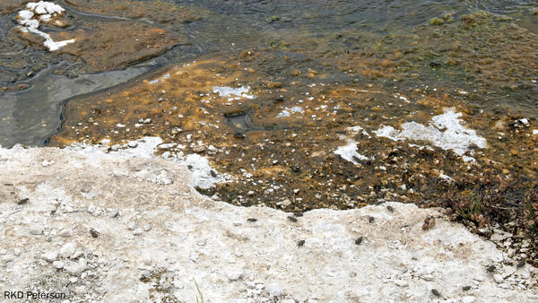
Adult tiger beetles near Midway Geyser Basin, Yellowstone National Park
Several adult wetsalts tiger beetles hunting and basking on and around an alkaline hot spring near Midway Geyser Basin in Yellowstone National Park. Photo by Robert K. D. Peterson, 2019.
Several adult wetsalts tiger beetles hunting and basking on and around an alkaline hot spring near Midway Geyser Basin in Yellowstone National Park. Photo by Robert K. D. Peterson, 2019.

Mineral stability diagram showing minerals that are stable under changing temperature and dissolved silica concentrations at and just beneath the floor of Yellowstone Lake
linkMineral stability diagram showing minerals that are stable under changing temperature and dissolved silica concentrations that are found at and just beneath the floor of Yellowstone Lake. Two important points illustrated by this diagram are: (1) the minerals that are stable when reacted with vapor-dominated fluids (kaolinite, boehmite) differ substantially fro

Dan Dzurisin
Dan Dzurisin, of the Cascades Volcano Observatory, conducting a leveling survey at Newberry Volcano, Oregon, in 2002.
Dan Dzurisin, of the Cascades Volcano Observatory, conducting a leveling survey at Newberry Volcano, Oregon, in 2002.

Sulphur Caldron
Sulphur Caldron -- an example of an acid-sulfate hydrothermal feature in Yellowstone National Park. Photo taken by Blaine McCleskey, September 2008.
Sulphur Caldron -- an example of an acid-sulfate hydrothermal feature in Yellowstone National Park. Photo taken by Blaine McCleskey, September 2008.

View of Castle Geyser, near Old Faithful, in eruption
View of Castle Geyser, near Old Faithful, in eruption, taken from the boardwalk, November 5, 2019.
View of Castle Geyser, near Old Faithful, in eruption, taken from the boardwalk, November 5, 2019.

Everts thistle in bloom.
This mountain meadow inhabiting species is generally distinctive in its long copious stem and leaf hairs and inflorescences with congested white to pinkish or light purplish flowering heads that are surrounded by very long stem leaves.
This mountain meadow inhabiting species is generally distinctive in its long copious stem and leaf hairs and inflorescences with congested white to pinkish or light purplish flowering heads that are surrounded by very long stem leaves.

Alpine meadow near Two Ocean Pass, just south of Yellowstone National Park
Alpine meadow near Two Ocean Pass on the Continental Divide just south of Yellowstone National Park.
Alpine meadow near Two Ocean Pass on the Continental Divide just south of Yellowstone National Park.

Image of the north part of Yellowstone Lake from September 2, 2019
Image of the north part of Yellowstone Lake with the smoke plume from the Brimstone Fire in the distance, acquired by the YVO webcam on September 2, 2019, at 2:05 PM MDT.
Image of the north part of Yellowstone Lake with the smoke plume from the Brimstone Fire in the distance, acquired by the YVO webcam on September 2, 2019, at 2:05 PM MDT.

The Parting of the Waters
The Parting of the Waters, looking southeast. North Two Ocean Creek splits into Atlantic Creek, flowing to the left in the photo, and Pacific Creek, flowing to the right. The wooden sign indicates that it is 3,488 miles to the Atlantic Ocean and 1,353 miles to the Pacific Ocean.
The Parting of the Waters, looking southeast. North Two Ocean Creek splits into Atlantic Creek, flowing to the left in the photo, and Pacific Creek, flowing to the right. The wooden sign indicates that it is 3,488 miles to the Atlantic Ocean and 1,353 miles to the Pacific Ocean.

Aerial view of new thermal area near Tern Lake, Yellowstone.
Aerial view of the new thermal area, in the center left. The existing Tern Lake thermal area is the bright white patch of ground in the upper middle part of the image. West Tern Lake is in the lower right. Research conducted under NPS Geology Programs Milestones Permit 2016-9.
Aerial view of the new thermal area, in the center left. The existing Tern Lake thermal area is the bright white patch of ground in the upper middle part of the image. West Tern Lake is in the lower right. Research conducted under NPS Geology Programs Milestones Permit 2016-9.

Tern Lake hydrothermal area from the ground, Yellowstone
View from the ground of the new thermal area near Tern Lake in Yellowstone National Park. Research conducted under NPS Geology Programs Milestones Permit 2016-9.
View from the ground of the new thermal area near Tern Lake in Yellowstone National Park. Research conducted under NPS Geology Programs Milestones Permit 2016-9.