
Rangers attempting to clean trash out of Morning Glory Pool in September 1975. National Park Service photograph Dan Ing.
Images
Images of Yellowstone.
Filter Total Items: 532

Rangers attempting to clean trash out of Morning Glory Pool in 1975.
Rangers attempting to clean trash out of Morning Glory Pool in September 1975. National Park Service photograph Dan Ing.

Aerial (balloon) view of Norris Geyser Basin, Yellowstone National Park, looking northwest from the south
linkAerial (balloon) view of Norris Geyser Basin, Yellowstone National Park, looking northwest from the south. USGS Photo by Brita Graham Wall, 2005.
Aerial (balloon) view of Norris Geyser Basin, Yellowstone National Park, looking northwest from the south
linkAerial (balloon) view of Norris Geyser Basin, Yellowstone National Park, looking northwest from the south. USGS Photo by Brita Graham Wall, 2005.

Grand Prismatic Spring, Midway Geyser Basin, Yellowstone National Park
Grand Prismatic Spring, Midway Geyser Basin, Yellowstone National Park. Grand Prismatic is the largest hot spring in Yellowstone and the third largest in the world. Photograph by Robert Fournier.
Grand Prismatic Spring, Midway Geyser Basin, Yellowstone National Park. Grand Prismatic is the largest hot spring in Yellowstone and the third largest in the world. Photograph by Robert Fournier.
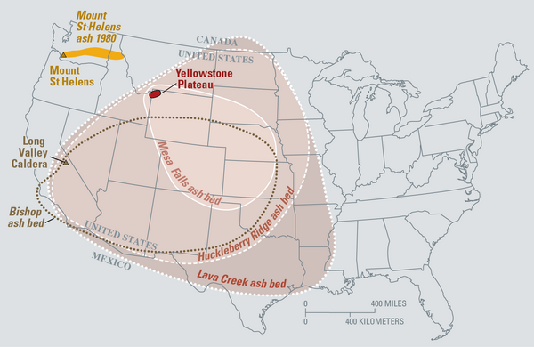
Map of the known ash-fall boundaries for several U.S. eruptions
Eruptions of the Yellowstone volcanic system have included the two largest volcanic eruptions in North America in the past few million years; the third largest was at Long Valley in California and produced the Bishop ash bed. The biggest of the Yellowstone eruptions occurred 2.1 million years ago, depositing the Huckleberry Ridge ash bed.
Eruptions of the Yellowstone volcanic system have included the two largest volcanic eruptions in North America in the past few million years; the third largest was at Long Valley in California and produced the Bishop ash bed. The biggest of the Yellowstone eruptions occurred 2.1 million years ago, depositing the Huckleberry Ridge ash bed.

Heise cliffs, the type location for the 4.45–7.0 million year old Heise Volcanic Field
Heise cliffs, the type location for the 4.45–7.0 million year old Heise Group from the Heise volcanic field, which preceded the Yellowstone Plateau volcanic field. Most of the cliffs exposed here are rhyolitic, densely welded, rhyolitic pyroclastic density flow deposits. USGS Photo by L. A. Morgan (May 2005).
Heise cliffs, the type location for the 4.45–7.0 million year old Heise Group from the Heise volcanic field, which preceded the Yellowstone Plateau volcanic field. Most of the cliffs exposed here are rhyolitic, densely welded, rhyolitic pyroclastic density flow deposits. USGS Photo by L. A. Morgan (May 2005).

Map showing earthquake focal mechanisms in the Yellowstone region
Map showing earthquake focal mechanisms in the Yellowstone region.
Map showing earthquake focal mechanisms in the Yellowstone region.

Exposure of rhyolite volcanic rocks in the central Snake River Plain
Exposure of rhyolite volcanic rocks in the central Snake River Plain showing a thick sequence of 10-12 million-year-old, densely welded, pyroclastic density flow units (darker units from middle of photo to top of hill) overlying a thick sequence of white, friable, ash fall deposits. USGS Photo by L. A. Morgan (May 2004).
Exposure of rhyolite volcanic rocks in the central Snake River Plain showing a thick sequence of 10-12 million-year-old, densely welded, pyroclastic density flow units (darker units from middle of photo to top of hill) overlying a thick sequence of white, friable, ash fall deposits. USGS Photo by L. A. Morgan (May 2004).

Densely welded rhyolites from the central Snake River Plain
Densely welded rhyolites from the central Snake River Plain. USGS Photo by L. A. Morgan (May 2004).
Densely welded rhyolites from the central Snake River Plain. USGS Photo by L. A. Morgan (May 2004).

Sheepeater Cliff, in Yellowstone National Park
Slow cooling of a basaltic lava flow that was erupted about 500,000 years ago resulted in the formation of hexagonal columns at Sheepeater Cliff, in Yellowstone National Park.
Slow cooling of a basaltic lava flow that was erupted about 500,000 years ago resulted in the formation of hexagonal columns at Sheepeater Cliff, in Yellowstone National Park.

Columnar-jointed lava flow in the wall of the Yellowstone River canyon
A 1.5-million-year-old basaltic lava flow in the canyon wall of the Yellowstone River as viewed from Calcite Springs Overlook near Tower Junction in Yellowstone National Park. Slow cooling of this lava flow resulted in the formation of vertical columns. Glacial gravels are present above and below the lava flow.
A 1.5-million-year-old basaltic lava flow in the canyon wall of the Yellowstone River as viewed from Calcite Springs Overlook near Tower Junction in Yellowstone National Park. Slow cooling of this lava flow resulted in the formation of vertical columns. Glacial gravels are present above and below the lava flow.

Angel Terrace, Mammoth Hot Springs, Yellowstone National Park
Angel Terrace, Mammoth Hot Springs, Yellowstone National Park. Travertine deposits are abundant in the area. Photo by JoAnn Holloway, 2003.
Angel Terrace, Mammoth Hot Springs, Yellowstone National Park. Travertine deposits are abundant in the area. Photo by JoAnn Holloway, 2003.

Norris-2003. Location map of seismometers and GPS receivers deploye...
Norris-2003. Location map of seismometers and GPS receivers deployed to help monitor the Norris Geyser Basin.
Norris-2003. Location map of seismometers and GPS receivers deployed to help monitor the Norris Geyser Basin.

Panoramic photo of area impacted during explosions at Norris in 2004
View to the southeast through the area affected by the increased thermal output at Norris' Back Basin in the summer of 2003. The foreground shows steaming areas where boiling water and steam have approached the surface, resulting in increased ground temperatures.
View to the southeast through the area affected by the increased thermal output at Norris' Back Basin in the summer of 2003. The foreground shows steaming areas where boiling water and steam have approached the surface, resulting in increased ground temperatures.

Bathymetric map of Yellowstone Lake
Bathymetric map of Yellowstone Lake showing hydrothermal features in the north part of the lake, including Elliott's Crater, Mary Bay, and Deep Hole. Colors correspond to lake depth, with cooler colors indicating greater depths.
Bathymetric map of Yellowstone Lake showing hydrothermal features in the north part of the lake, including Elliott's Crater, Mary Bay, and Deep Hole. Colors correspond to lake depth, with cooler colors indicating greater depths.

Criteria for estimation of the Volcanic Explosivity Index (VEI)
Criteria for estimation of the Volcanic Explosivity Index (VEI). Modified from: Newhall, C.G., and Self, S., 1982, The volcanic explosivity index (VEI): An estimate of explosive magnitude for historical volcanism. Journal of Geophysical Research, v. 87, no. C2, p.
Criteria for estimation of the Volcanic Explosivity Index (VEI). Modified from: Newhall, C.G., and Self, S., 1982, The volcanic explosivity index (VEI): An estimate of explosive magnitude for historical volcanism. Journal of Geophysical Research, v. 87, no. C2, p.

MODIS satellite image of New Zealand’s North Island
MODIS satellite image of New Zealand’s North Island acquired on October 23, 2002 (https://earthobservatory.nasa.gov/images/3101/new-zealand). Lake Taupō is located in the center of North Island.
MODIS satellite image of New Zealand’s North Island acquired on October 23, 2002 (https://earthobservatory.nasa.gov/images/3101/new-zealand). Lake Taupō is located in the center of North Island.

Geological Map of the Monument Geyser Basin area
Geological Map of the area around Monument Geyser Basin and Beryl Spring, taken from the Geological Map of the Yellowstone Plateau Area (Christiansen, 2001)
Geological Map of the area around Monument Geyser Basin and Beryl Spring, taken from the Geological Map of the Yellowstone Plateau Area (Christiansen, 2001)

Geologic map of the Yellowstone Plateau Volcanic field
Geologic map of the Yellowstone Plateau Volcanic field generated by Bob Christiansen and published in 2001. Available from https://pubs.usgs.gov/pp/pp729g/plate1.pdf.
Geologic map of the Yellowstone Plateau Volcanic field generated by Bob Christiansen and published in 2001. Available from https://pubs.usgs.gov/pp/pp729g/plate1.pdf.

Locations of Yellowstone hotspot volcanic fields
Map of the northwestern U.S., showing the approximate locations of Yellowstone hotspot volcanic fields (orange) and Columbia River Basalts (gray). Boundary of Yellowstone National Park is shown in yellow. Modified from Barry et al. (GSA Special Paper 497, p.
Map of the northwestern U.S., showing the approximate locations of Yellowstone hotspot volcanic fields (orange) and Columbia River Basalts (gray). Boundary of Yellowstone National Park is shown in yellow. Modified from Barry et al. (GSA Special Paper 497, p.

Scientist from the USGS collects a gas sample into an evacuated/vac...
Scientist from the USGS collects a gas sample into an evacuated/vacuum flas from a steam vent near the Shoshone Geyser Basin.
Scientist from the USGS collects a gas sample into an evacuated/vacuum flas from a steam vent near the Shoshone Geyser Basin.

Obsidian Cliff, YNP.
Obsidian Cliff exposes the interior of a thick rhyolite lava flow erupted about 180,000 years ago. The vertical columns are cooling fractures that formed as the thick lava flow cooled and crystallized. The flow consists of obsidian, a dark volcanic glass.
Obsidian Cliff exposes the interior of a thick rhyolite lava flow erupted about 180,000 years ago. The vertical columns are cooling fractures that formed as the thick lava flow cooled and crystallized. The flow consists of obsidian, a dark volcanic glass.