
Photograph of electric cable measurement at well ER-8-1 as part of the U.S. Geological Survey-U.S. Department of Energy Cooperative Studies Program.
Images
Images intro.
Filter Total Items: 63

ER-8-1 Well
Photograph of electric cable measurement at well ER-8-1 as part of the U.S. Geological Survey-U.S. Department of Energy Cooperative Studies Program.
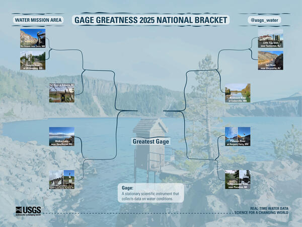
2025 Gage Greatness National Bracket Round One
At the USGS, we monitor our nation’s water. Our data informs many people, from kayakers to water managers. Gage Greatness allows any Instagram user to vote for their favorite gage (data collection station).
By
Water Resources Mission Area, Maryland-Delaware-D.C. Water Science Center, Nevada Water Science Center, New Jersey Water Science Center, New Mexico Water Science Center, Ohio-Kentucky-Indiana Water Science Center, Pennsylvania Water Science Center, South Atlantic Water Science Center (SAWSC), Upper Midwest Water Science Center, Washington Water Science Center

Cinnamon teal wearing a tracking backpack
Cinnamon teal with a GPS tracking backpack that weighs 10 grams, making it much more successful in staying on longer than heavier tracking devices.
Cinnamon teal with a GPS tracking backpack that weighs 10 grams, making it much more successful in staying on longer than heavier tracking devices.

2024 Lake Tahoe Summit
Distance shot of crown gathered for the 2024 Lake Tahoe Summit. Lake Tahoe Summit attendees listen to opening remarks from U.S. Senator Catherine Cortez Masto from Nevada.
Distance shot of crown gathered for the 2024 Lake Tahoe Summit. Lake Tahoe Summit attendees listen to opening remarks from U.S. Senator Catherine Cortez Masto from Nevada.

Shore of Lake Abert, Oregon
Lake Abert, Oregon is one of the 20 terminal lakes identified by USGS partners as priority ecosystems for study by the Saline Lakes Ecosystems IWAA.
By
Ecosystems Mission Area, Water Resources Mission Area, Forest and Rangeland Ecosystem Science Center, Fort Collins Science Center, Nevada Water Science Center, Oregon Water Science Center, Utah Water Science Center, Western Ecological Research Center (WERC), Saline Lake Ecosystems Integrated Water Availability Assessment

Goose Lake, Oregon-California
Goose Lake, on the Oregon-California border, is one of the 20 terminal lakes identified by USGS partners as priority ecosystems for study by the Saline Lakes Ecosystems IWAA.
By
Ecosystems Mission Area, Water Resources Mission Area, Species Management Research Program, Water Resources Research Act Program, Forest and Rangeland Ecosystem Science Center, Fort Collins Science Center, Nevada Water Science Center, Oregon Water Science Center, Utah Water Science Center, Western Ecological Research Center (WERC), Saline Lake Ecosystems Integrated Water Availability Assessment

Carson River Basin Hydro Mapper
The Carson River Basin Hydro Mapper web application provides a modern and easy-to-use interface with the USGS National Water Information System (NWIS). It is also a one-stop location for visually descriptive summaries of USGS, SNOTEL, National Weather Service, Advanced Hydrologic Prediction Service, and other local and regional hydrologic data with access
The Carson River Basin Hydro Mapper web application provides a modern and easy-to-use interface with the USGS National Water Information System (NWIS). It is also a one-stop location for visually descriptive summaries of USGS, SNOTEL, National Weather Service, Advanced Hydrologic Prediction Service, and other local and regional hydrologic data with access

A hovercraft glides over the surface of Summer Lake, Oregon
Summer Lake, Oregon is one of the 20 terminal lakes identified by USGS partners as priority ecosystems for study by the Saline Lakes Ecosystems IWAA.
By
Ecosystems Mission Area, Water Resources Mission Area, Species Management Research Program, Water Availability and Use Science Program, Forest and Rangeland Ecosystem Science Center, Fort Collins Science Center, Nevada Water Science Center, Oregon Water Science Center, Utah Water Science Center, Western Ecological Research Center (WERC), Saline Lake Ecosystems Integrated Water Availability Assessment

NWIS Mapper Arsenic Sites Nevada
Screenshot of the NWIS Mapper showing location of sites in Nevada where samples of groundwater were collected to evaluate arsenic speciation.
Screenshot of the NWIS Mapper showing location of sites in Nevada where samples of groundwater were collected to evaluate arsenic speciation.

2023 Tahoe Summit crowd
Audience at Tahoe summit, Wednesday, August 9, 2023. With Sen. Alex Padilla as event host.
Audience at Tahoe summit, Wednesday, August 9, 2023. With Sen. Alex Padilla as event host.

Cover - 2023 Lake Tahoe Summit Info Sheet
Cover - 2023 Lake Tahoe Summit Info Sheet. Title: 2023 Lake Tahoe Water Monitoring and Research Activities
Cover - 2023 Lake Tahoe Summit Info Sheet. Title: 2023 Lake Tahoe Water Monitoring and Research Activities

USGS Booth at 2023 Tahoe Summit
USGS Booth at 2023 Tahoe Summit - Wednesday, August 9th, 2023, with host Sen. Alex Padilla
USGS Booth at 2023 Tahoe Summit - Wednesday, August 9th, 2023, with host Sen. Alex Padilla

Gwendolyn Davies
This is an image for the staff profile for Gwendolyn Davies, Hydrologist, USGS
This is an image for the staff profile for Gwendolyn Davies, Hydrologist, USGS

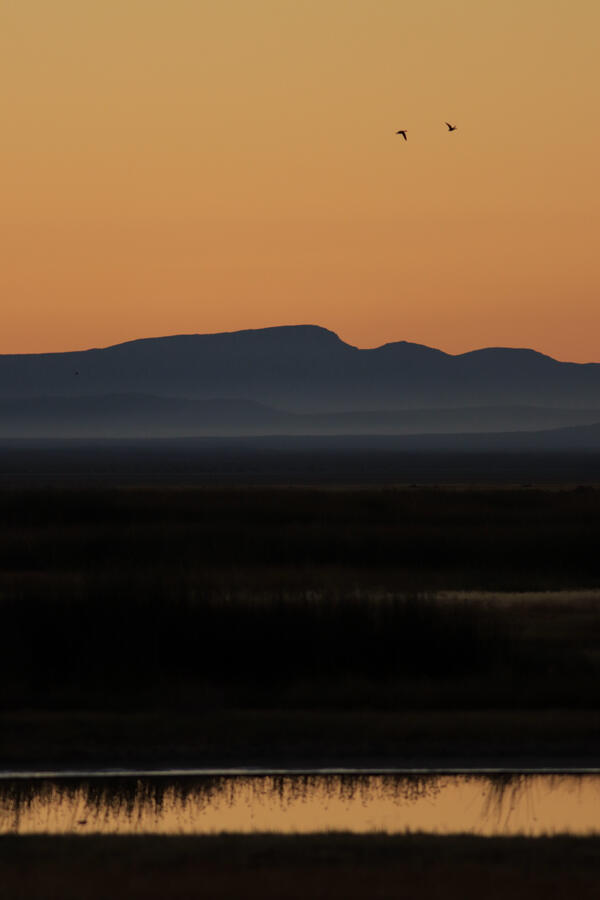
Avocets flying above Farmington Bay Wildlife Management Area, Utah
The Saline Lake Ecosystems IWAA Waterbird Movement Project began tagging American Avocets in March 2023 to track their movements across the landscape. Tracking data from these birds will help scientists better understand why these birds choose to use the terminal lake and wetland habitats they do in the Great Basin.
By
Ecosystems Mission Area, Water Resources Mission Area, Species Management Research Program, Water Resources Research Act Program, Forest and Rangeland Ecosystem Science Center, Fort Collins Science Center, Nevada Water Science Center, Oregon Water Science Center, Utah Water Science Center, Western Ecological Research Center (WERC), Saline Lake Ecosystems Integrated Water Availability Assessment

Walking the shallows of Lake Abert, Oregon
Lake Abert, Oregon is one of the 20 terminal lakes identified by USGS partners as priority ecosystems for study by the Saline Lakes Ecosystems IWAA.
By
Ecosystems Mission Area, Water Resources Mission Area, Species Management Research Program, Water Availability and Use Science Program, Forest and Rangeland Ecosystem Science Center, Fort Collins Science Center, Nevada Water Science Center, Oregon Water Science Center, Utah Water Science Center, Western Ecological Research Center (WERC), Saline Lake Ecosystems Integrated Water Availability Assessment
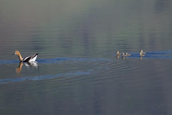
American Avocet trailed by chicks
American Avocet are a bird that relies heavily on the Saline Lakes ecosystem during their spring migration periods. Over 50% of these birds exist here. Part of their use includes using the terminal lakes there to breed.
By
Ecosystems Mission Area, Water Resources Mission Area, Species Management Research Program, Forest and Rangeland Ecosystem Science Center, Fort Collins Science Center, Nevada Water Science Center, Oregon Water Science Center, Utah Water Science Center, Western Ecological Research Center (WERC), Saline Lake Ecosystems Integrated Water Availability Assessment
Summer Lake Wildlife Area
Photograph of Summer Lake Wildlife Area, an important stopping spot for migratory birds on their spring and fall migration flights.
By
Ecosystems Mission Area, Water Resources Mission Area, Species Management Research Program, Forest and Rangeland Ecosystem Science Center, Fort Collins Science Center, Nevada Water Science Center, Utah Water Science Center, Western Ecological Research Center (WERC), Saline Lake Ecosystems Integrated Water Availability Assessment

Mason Valley, Nevada
Agriculture fields in Mason Valley, Nevada. This area was studied for a Scientific Investigations Report 2022-5123.
Agriculture fields in Mason Valley, Nevada. This area was studied for a Scientific Investigations Report 2022-5123.

Lone goose at sunrise at Summer Lake Wildlife Area
Looking east on Bullgate Pond at sunrise with lone tule white-fronted goose (Anser albifrons elgasi) in upper right, Summer Lake Wildlife Area, near Summer Lake, Oregon.
By
Ecosystems Mission Area, Water Resources Mission Area, Species Management Research Program, Water Availability and Use Science Program, Forest and Rangeland Ecosystem Science Center, Fort Collins Science Center, Nevada Water Science Center, Oregon Water Science Center, Utah Water Science Center, Western Ecological Research Center (WERC), Saline Lake Ecosystems Integrated Water Availability Assessment
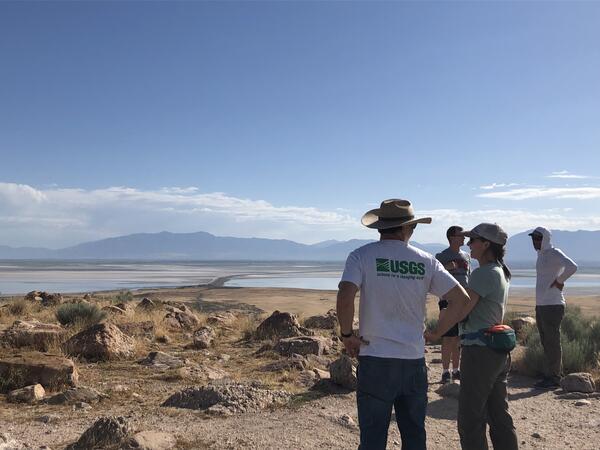
Scientist looking out onto the GSL from Antelope Island
These scientists are working on The Great Salt Lake to determine the amount of water and qualities of it. This will help them in developing better management techniques that will work to support the migratory birds that frequent the area.
By
Ecosystems Mission Area, Water Resources Mission Area, Species Management Research Program, Forest and Rangeland Ecosystem Science Center, Fort Collins Science Center, Nevada Water Science Center, Oregon Water Science Center, Utah Water Science Center, Western Ecological Research Center (WERC), Saline Lake Ecosystems Integrated Water Availability Assessment
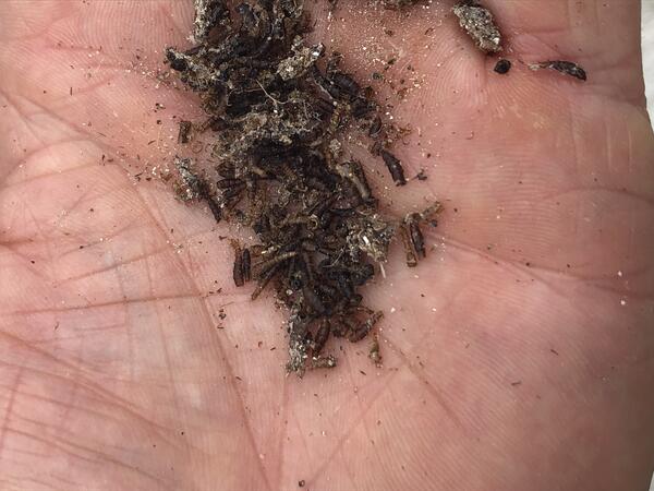
Brine fly pile
These brine flies are an important fuel source for migratory birds, giving them energy for long flights.
By
Ecosystems Mission Area, Water Resources Mission Area, Species Management Research Program, Forest and Rangeland Ecosystem Science Center, Nevada Water Science Center, Oregon Water Science Center, Utah Water Science Center, Western Ecological Research Center (WERC), Saline Lake Ecosystems Integrated Water Availability Assessment