
Regional map of southern California showing the study region from Dana Point to La Jolla Cove.
Images
Images intro.
Filter Total Items: 1205

Regional map of southern California from Dana Point to La Jolla Cove.
Regional map of southern California showing the study region from Dana Point to La Jolla Cove.

Photo collage of examples of invasive species likely to leave a fossil record
Examples of invasive species likely to leave a fossil record: a, Asian clams at Teddington Lock on the River Thames, UK; b, Asian clams in the River Soar, Leicestershire, UK; c, quagga mussels revealed on the rocks lining Grafham Water reservoir, UK, during low water levels.; d, zebra mussels on a native freshwater clam in Manitoba, Canada; e, Himalayan balsam along
Examples of invasive species likely to leave a fossil record: a, Asian clams at Teddington Lock on the River Thames, UK; b, Asian clams in the River Soar, Leicestershire, UK; c, quagga mussels revealed on the rocks lining Grafham Water reservoir, UK, during low water levels.; d, zebra mussels on a native freshwater clam in Manitoba, Canada; e, Himalayan balsam along

Diagram showing late 20th and 21st century production of cultivated fruits and vegetables and fiberboard
linkLate 20th and 21st century production of avocados, coconuts, mangos, peach, walnut, palm kernels, snails and medium-density fiberboard.
Diagram showing late 20th and 21st century production of cultivated fruits and vegetables and fiberboard
linkLate 20th and 21st century production of avocados, coconuts, mangos, peach, walnut, palm kernels, snails and medium-density fiberboard.

Aerial orthomosaic photo of Whale's Tail Marsh south in May 2022
Aerial orthomosaic photo of Whale's Tail Marsh south (WTMS) in May 2022 with marsh-edge boundary drawn in orange at elevation of the scarp head contour.
Aerial orthomosaic photo of Whale's Tail Marsh south (WTMS) in May 2022 with marsh-edge boundary drawn in orange at elevation of the scarp head contour.

A USGS researcher in a kayak tows instruments to measure water level and suspended-sediment concentration
linkA USGS researcher in a kayak tows instruments to measure water level and suspended-sediment concentration in Whale's Tail South marsh, San Francisco Bay, CA.
A USGS researcher in a kayak tows instruments to measure water level and suspended-sediment concentration
linkA USGS researcher in a kayak tows instruments to measure water level and suspended-sediment concentration in Whale's Tail South marsh, San Francisco Bay, CA.

A semipalmated plover (a small shorebird) consuming a polychaete worm in an intertidal area
A semipalmated plover (a small shorebird) consuming a polychaete worm in an intertidal area.
A semipalmated plover (a small shorebird) consuming a polychaete worm in an intertidal area.

Restored tidal marsh at Nisqually River Delta
Restored tidal marsh at the Nisqually River Delta within Billy Frank Jr. National Wildlife Refuge, Washington.
Restored tidal marsh at the Nisqually River Delta within Billy Frank Jr. National Wildlife Refuge, Washington.
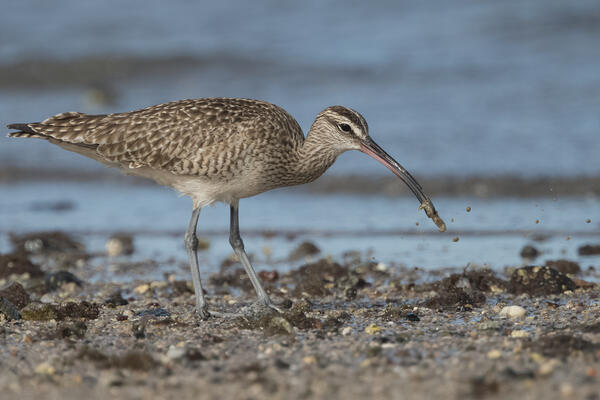
A whimbrel (a large shorebird) consuming a burrowing shrimp in an intertidal area
A whimbrel (a large shorebird) consuming a burrowing shrimp in an intertidal area.
A whimbrel (a large shorebird) consuming a burrowing shrimp in an intertidal area.

Study area of benthic macroinvertebrate response to Nisqually River Delta marsh restoration
Sampling sites are color-coded by habitat. White labels indicate site names. Marsh sites: U1, Unit 1; U2, Unit 2; U3, Unit 3; U4, Unit 4; M, Madrone; P1, Phase 1 restoration; P2, Phase 2 restoration; RF, reference. For Marsh sites, the last letter indicates the position along a tidal channel: N, north; M, middle; S, south; W, west.
Sampling sites are color-coded by habitat. White labels indicate site names. Marsh sites: U1, Unit 1; U2, Unit 2; U3, Unit 3; U4, Unit 4; M, Madrone; P1, Phase 1 restoration; P2, Phase 2 restoration; RF, reference. For Marsh sites, the last letter indicates the position along a tidal channel: N, north; M, middle; S, south; W, west.

Satellite-derived shorelines for a barrier island east of Moses Point Fishing Village, Norton Sound, Alaska
linkSatellite-derived shorelines for a barrier island east of Moses Point Fishing Village, Norton Sound, Alaska, from the study CoastSeg: an accessible and extendable hub for satellite-derived-shoreline (SDS) detection and mapping.

Screenshot of CoastSeg interface
Screenshot of CoastSeg interface, from the study CoastSeg: an accessible and extendable hub for satellite-derived-shoreline (SDS) detection and mapping.
Screenshot of CoastSeg interface, from the study CoastSeg: an accessible and extendable hub for satellite-derived-shoreline (SDS) detection and mapping.

Satellite images of barrier island near Moses Point Fishing Village, taken in 1986 and 2023
Satellite images of barrier island near Moses Point Fishing Village, Norton Sound, Alaska, taken in 1986 and 2023.
Satellite images of barrier island near Moses Point Fishing Village, Norton Sound, Alaska, taken in 1986 and 2023.

Schematic of trace metal inputs in a potential deep-sea mining dewatering waste plume
Schematic of the trace metal inputs in a potential deep-sea mining dewatering waste plume and accidental spills from both the riser pipe and the mining platform. The section plot is dissolved oxygen concentrations along 12° N. Dissolved oxygen data are retrieved from the World Ocean Atlas 2018 annual climatology, and the gray contours are oxygen concentrations.
Schematic of the trace metal inputs in a potential deep-sea mining dewatering waste plume and accidental spills from both the riser pipe and the mining platform. The section plot is dissolved oxygen concentrations along 12° N. Dissolved oxygen data are retrieved from the World Ocean Atlas 2018 annual climatology, and the gray contours are oxygen concentrations.

Map showing location of mapped submarine landslides off the southern California coast
Regional land area/bathymetric map including submarine landslides, headwall scarps, and mass wasting zones compiled and mapped offshore of southern California for the study A comprehensive assessment of submarine landslides and mass wasting processes offshore southern California.
Regional land area/bathymetric map including submarine landslides, headwall scarps, and mass wasting zones compiled and mapped offshore of southern California for the study A comprehensive assessment of submarine landslides and mass wasting processes offshore southern California.

Diagram of the San Nicolas submarine landslide off the southern California coast
San Nicolas slide.

Map showing aftershock zones of great Aleutian Islands earthquakes in the 20th century
Map showing aftershock zones of great Aleutian Islands, Alaska, earthquakes in the 20th century. Red solid line with pink fill indicates aftershock zone of the 1957 Aleutian Islands earthquake from Sykes et al.
Map showing aftershock zones of great Aleutian Islands, Alaska, earthquakes in the 20th century. Red solid line with pink fill indicates aftershock zone of the 1957 Aleutian Islands earthquake from Sykes et al.

Animated GIF of Aleutian Islands 1957 tsunami simulation
Animated GIF of a simulation of the Aleutian Islands, Alaska 1957 magnitude 8.6 tsunami.
Animated GIF of a simulation of the Aleutian Islands, Alaska 1957 magnitude 8.6 tsunami.

Cover image for timelapse at the Elwha River Mouth on the Olympic Peninsula in Washington.
Cover image for timelapse at the Elwha River Mouth on the Olympic Peninsula in Washington.
Cover image for timelapse at the Elwha River Mouth on the Olympic Peninsula in Washington.

Elwha River Mouth flyover and timelapse cover image
Cover image for flyover and timelapse at the Elwha River Mouth on the Olympic Peninsula in Washington.
Cover image for flyover and timelapse at the Elwha River Mouth on the Olympic Peninsula in Washington.

Cover image for timelapse at Lower Lake Aldwell, Elwha River, on the Olympic Peninsula in Washington
linkCover image for timelapse at Lower Lake Aldwell, Elwha River, on the Olympic Peninsula in Washington.
Cover image for timelapse at Lower Lake Aldwell, Elwha River, on the Olympic Peninsula in Washington
linkCover image for timelapse at Lower Lake Aldwell, Elwha River, on the Olympic Peninsula in Washington.

Cover image for timelapse at Glines Canyon, Elwha River, on the Olympic Peninsula in Washington
linkCover image for timelapse at Glines Canyon, Elwha River, on the Olympic Peninsula in Washington.
Cover image for timelapse at Glines Canyon, Elwha River, on the Olympic Peninsula in Washington
linkCover image for timelapse at Glines Canyon, Elwha River, on the Olympic Peninsula in Washington.