A 200-kilogram (440-pound) fragment of the Canyon Diablo meteorite that was found at Meteor Crater in Arizona
linkA 200-kilogram (440-pound) fragment of the Canyon Diablo meteorite that was found at Meteor Crater in Arizona.

Official websites use .gov
A .gov website belongs to an official government organization in the United States.
Secure .gov websites use HTTPS
A lock () or https:// means you’ve safely connected to the .gov website. Share sensitive information only on official, secure websites.
A 200-kilogram (440-pound) fragment of the Canyon Diablo meteorite that was found at Meteor Crater in Arizona.
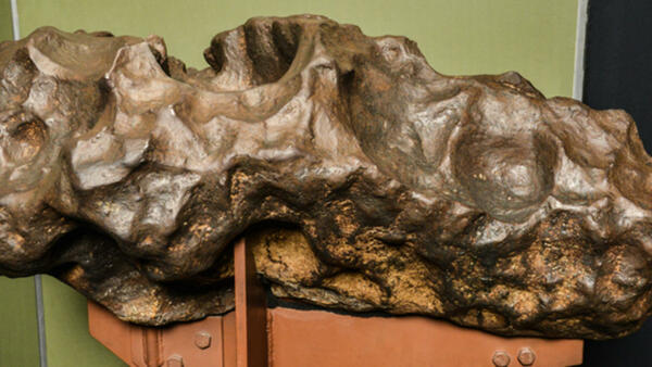
A 200-kilogram (440-pound) fragment of the Canyon Diablo meteorite that was found at Meteor Crater in Arizona.

Boiling River near Mammoth Hot Springs, Yellowstone National Park. Photo by R. Robinson.
Boiling River near Mammoth Hot Springs, Yellowstone National Park. Photo by R. Robinson.

Map of the Uhl Hill fault in eastern Grand Teton National Park. Base map is a 1-meter lidar hillshade. Black arrows mark the visible fault scarp, and red lines mark locations where scarp profiles were generated from lidar data or field surveying.
Map of the Uhl Hill fault in eastern Grand Teton National Park. Base map is a 1-meter lidar hillshade. Black arrows mark the visible fault scarp, and red lines mark locations where scarp profiles were generated from lidar data or field surveying.

Scarp of the Uhl Hill fault. Photo (top) is looking west at the east-facing fault scarp, with a geologist at the top of the scarp for scale. Here, the fault cuts through Pinedale-1 glacial deposits just south of a Pinedale-2 end moraine. Plot (bottom) is a scarp profile generated from lidar elevation data.
Scarp of the Uhl Hill fault. Photo (top) is looking west at the east-facing fault scarp, with a geologist at the top of the scarp for scale. Here, the fault cuts through Pinedale-1 glacial deposits just south of a Pinedale-2 end moraine. Plot (bottom) is a scarp profile generated from lidar elevation data.

Simplified geologic maps showing the difference in mapped rock units from the current, large-scale geologic maps dividing Mount Everts and that join along the boundary between Montana and Wyoming.
Simplified geologic maps showing the difference in mapped rock units from the current, large-scale geologic maps dividing Mount Everts and that join along the boundary between Montana and Wyoming.

Satellite radar interferogram spanning June 19, 2020, to August 13, 2021, and showing the ground motion in the direction of the satellite.
Satellite radar interferogram spanning June 19, 2020, to August 13, 2021, and showing the ground motion in the direction of the satellite.

Reconstructed fossil horse skeleton found at Hagerman Fossil Beds National Monument, Idaho. National Park Service photo, https://www.nps.gov/articles/000/equus_simplicidens.htm.
Reconstructed fossil horse skeleton found at Hagerman Fossil Beds National Monument, Idaho. National Park Service photo, https://www.nps.gov/articles/000/equus_simplicidens.htm.

Michelle Coombs is a volcanologist with the U.S. Geological Survey Volcano Hazards Program. She works out of the Alaska Science Center in Anchorage, Alaska.
Michelle Coombs is a volcanologist with the U.S. Geological Survey Volcano Hazards Program. She works out of the Alaska Science Center in Anchorage, Alaska.

Regional map of southeastern Idaho showing the relative location of Yellowstone National Park and the Stanley earthquake aftershocks. Yellowstone National Park (outlined in yellow) is at least 275 km away from the 2020 Mw6.5 Stanley earthquake. Several active faults (in red) are located between the Stanley earthquake and Yellowstone Caldera.
Regional map of southeastern Idaho showing the relative location of Yellowstone National Park and the Stanley earthquake aftershocks. Yellowstone National Park (outlined in yellow) is at least 275 km away from the 2020 Mw6.5 Stanley earthquake. Several active faults (in red) are located between the Stanley earthquake and Yellowstone Caldera.

Cumulative number of aftershocks greater than magnitude 2.5 following the March 30, 2020, magnitude-6.5 Stanley earthquake in central Idaho. The black line shows the observed aftershocks, the red line shows the predicted number of aftershocks. Aftershocks are a normal and expected phenomenon following strong tectonic earthquakes.
Cumulative number of aftershocks greater than magnitude 2.5 following the March 30, 2020, magnitude-6.5 Stanley earthquake in central Idaho. The black line shows the observed aftershocks, the red line shows the predicted number of aftershocks. Aftershocks are a normal and expected phenomenon following strong tectonic earthquakes.

A branching root cast from grasses that grew on the ashy lahars deposited along the ancestral Missouri River system. Plant roots growing in calcareous soils made holes that were filled with calcite after the organics rotted away. Photo by Rob Thomas, August 2021.
A branching root cast from grasses that grew on the ashy lahars deposited along the ancestral Missouri River system. Plant roots growing in calcareous soils made holes that were filled with calcite after the organics rotted away. Photo by Rob Thomas, August 2021.

Comparison of (a) 1904 Historical map with (b) 1988 USGS map. Colloidal Pool is a large, labeled pool roughly located on a straight line between Hurricane vent and Whirligig Geyser on the 1988 map (b); this same transect on the 1904 map (a) shows no feature at that location (white circle).
Comparison of (a) 1904 Historical map with (b) 1988 USGS map. Colloidal Pool is a large, labeled pool roughly located on a straight line between Hurricane vent and Whirligig Geyser on the 1988 map (b); this same transect on the 1904 map (a) shows no feature at that location (white circle).

Scanning electron microscopy (SEM) images of the Colloidal Pool colloids (images are a combination of backscatter and secondary electrons). The colloids are a mixture of clay particles, hydrated silica, alunite, and diatoms.
Scanning electron microscopy (SEM) images of the Colloidal Pool colloids (images are a combination of backscatter and secondary electrons). The colloids are a mixture of clay particles, hydrated silica, alunite, and diatoms.

A view of White Mountain -- a deposit of the Heart Mountain detachment -- from the Sunlight Basin Road in Wyoming. Much of the evidence supporting the lamprophyre diatreme triggering mechanism theory for the landslide was gathered at White Mountain.
A view of White Mountain -- a deposit of the Heart Mountain detachment -- from the Sunlight Basin Road in Wyoming. Much of the evidence supporting the lamprophyre diatreme triggering mechanism theory for the landslide was gathered at White Mountain.

Photograph of Michael Poland, geophysicist with the U.S. Geological Survey and Scientist-in-Charge of the Yellowstone Volcano Observatory.
Photograph of Michael Poland, geophysicist with the U.S. Geological Survey and Scientist-in-Charge of the Yellowstone Volcano Observatory.

Site of the former Fountain Hotel in Yellowstone National Park. Red arrows indicate the location of the pipe that ran through the meadow between Leather Pool and the site of the Fountain Hotel (yellow arrow). Yellowstone National Park photo by Annie Carlson, October 2021.
Site of the former Fountain Hotel in Yellowstone National Park. Red arrows indicate the location of the pipe that ran through the meadow between Leather Pool and the site of the Fountain Hotel (yellow arrow). Yellowstone National Park photo by Annie Carlson, October 2021.

Interferogram created from data collected on September 22, 2020, and September 17, 2021, by the Sentinel-1 satellite system. Colored fringes indicate a change in distance (called range change) between the satellite and ground surface that is caused by surface deformation.
Interferogram created from data collected on September 22, 2020, and September 17, 2021, by the Sentinel-1 satellite system. Colored fringes indicate a change in distance (called range change) between the satellite and ground surface that is caused by surface deformation.

Typical exposure of tabular blocks of layered ash in a matrix of cross-bedded ash. The tabular blocks were deposited, rapidly hardened, and ripped up and transported downstream along the ancestral Missouri River system with another pulse of ash and water, forming the cross-bedded matrix.
Typical exposure of tabular blocks of layered ash in a matrix of cross-bedded ash. The tabular blocks were deposited, rapidly hardened, and ripped up and transported downstream along the ancestral Missouri River system with another pulse of ash and water, forming the cross-bedded matrix.

“Hey Bear” volcano, Wyoming, with Raggedtop Mountain in the background. Hey Bear volcano is a small scoria cone that is about 1.3 million years old and that erupted over Eocene (~50 million-year-old) rocks (noted by yellow dotted line). Photo by Matthew Brueseke, Kansas State University, August 2021, used with permission.
“Hey Bear” volcano, Wyoming, with Raggedtop Mountain in the background. Hey Bear volcano is a small scoria cone that is about 1.3 million years old and that erupted over Eocene (~50 million-year-old) rocks (noted by yellow dotted line). Photo by Matthew Brueseke, Kansas State University, August 2021, used with permission.

Photograph of Twin Buttes in Lower Geyser Basin looking to the northwest, with Excelsior Geyser of Midway Geyser Basin in the foreground. Twin Buttes is a thermal kame that formed when glaciers covered the area, and hydrothermal activity below the ice led to melting and the deposition and cementation of glacial sediments.
Photograph of Twin Buttes in Lower Geyser Basin looking to the northwest, with Excelsior Geyser of Midway Geyser Basin in the foreground. Twin Buttes is a thermal kame that formed when glaciers covered the area, and hydrothermal activity below the ice led to melting and the deposition and cementation of glacial sediments.

Imperial Geyser, Lower Geyser Basin, Yellowstone National Park. USGS photo by Lauren Harrison, July 2021.
Imperial Geyser, Lower Geyser Basin, Yellowstone National Park. USGS photo by Lauren Harrison, July 2021.