
Big Southern Butte, Idaho. The butte is among the largest rhyolite domes in the world and is located in the eastern Snake River Plain. Photo by James Neeley, BLM (https://flic.kr/p/CsA4TV).
Images
Images intro.
Filter Total Items: 366

Big Southern Butte, Idaho
Big Southern Butte, Idaho. The butte is among the largest rhyolite domes in the world and is located in the eastern Snake River Plain. Photo by James Neeley, BLM (https://flic.kr/p/CsA4TV).

Lidar coverage of the Hebgen and Red Canyon faults collected in 2014
Lidar coverage of the Hebgen and Red Canyon faults collected in 2014. Magenta lines show fault scarps mapped by USGS geologists shortly after the 1959 earthquake. Yellow lines show fault scarps interpreted from lidar data 55 years after the earthquake.
Lidar coverage of the Hebgen and Red Canyon faults collected in 2014. Magenta lines show fault scarps mapped by USGS geologists shortly after the 1959 earthquake. Yellow lines show fault scarps interpreted from lidar data 55 years after the earthquake.

Lava Mountain, Wyoming
Lava Mountain, Wyoming. (A) View from Dubois, WY, in the Wind River basin looking northwest ~30 km toward Lava Mountain.
Lava Mountain, Wyoming. (A) View from Dubois, WY, in the Wind River basin looking northwest ~30 km toward Lava Mountain.

Frosted trees in the Fairy Falls area of Yellowstone National Park near the Firehole River
Frosted trees in the Fairy Falls area of Yellowstone National Park near the Firehole River. National Park Service photo by Annie Carlson, 2014.
Frosted trees in the Fairy Falls area of Yellowstone National Park near the Firehole River. National Park Service photo by Annie Carlson, 2014.

Schematic cross section of the magmatic and hydrothermal systems underlying Yellowstone Caldera
linkSchematic cross section of the magmatic and hydrothermal systems underlying Yellowstone Caldera, showing magmatic volatiles emitted during crystallization of the rhyolitic magma and/or from basalt intrusions or convection, and the hypothesized relation with earthquake swarms on the caldera margins. The exsolved fluids accumulate at lithostatic pressures in the

Photo of the Old Faithful Inn lobby
Photo of the Old Faithful Inn lobby, which features a six-story-tall fireplace and chimney made from rocks quarried form a rhyolite lava flow in Yellowstone. NPS photo by Jim Peaco, July 22, 2013.
Photo of the Old Faithful Inn lobby, which features a six-story-tall fireplace and chimney made from rocks quarried form a rhyolite lava flow in Yellowstone. NPS photo by Jim Peaco, July 22, 2013.

View north along U.S. Route 20 from near Ashton, ID, at the margin of the Huckleberry Ridge Tuff in the distance
linkGoogle maps photo taken just north of Ashton, ID, along U.S. Route 20. The photo was taken looking north towards Island Park, ID. The forested ridge in the distance marks the margin of a caldera that formed 2.08 million years ago, when the Huckleberry Ridge Tuff erupted.
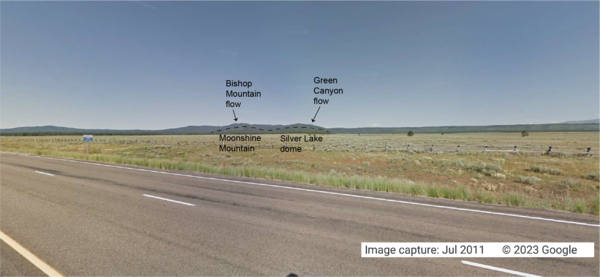
Looking west from the intersection of U.S. Route 20 and Old Hwy 47, in Idaho, at lava flows associated with the Henrys Fork caldera
linkGoogle Maps photo taken at the intersection of U.S. Route 20 and Old Hwy 47 in Idaho, looking west. The tops of Moonshine Mountain and Silver Lake dome, rhyolite lava flows located inside the caldera, are indicated with a dashed black line.

Photo of the Madison Museum, Yellowstone National Park
Photo of the Madison Museum, built in 1930 and designed by Herbert Maier. This structure exemplifies the National Park Rustic style, using natural materials and artisan craftmanship that are intended to blend buildings into the surrounding environment, “suggesting the smallness of man in relation to nature” (Herbert Maier).
Photo of the Madison Museum, built in 1930 and designed by Herbert Maier. This structure exemplifies the National Park Rustic style, using natural materials and artisan craftmanship that are intended to blend buildings into the surrounding environment, “suggesting the smallness of man in relation to nature” (Herbert Maier).

Bob Fournier measuring the gas-to-water ratio (gas/steam) at drill site Y2 in Yellowstone National Park
linkBob Fournier measuring the gas-to-water ratio (gas/steam) at drill site Y2, near Hot Lake on Firehole Lake Drive in Lower Geyser Basin, Yellowstone National Park, in the late 1960s. USGS Photo.

Terrace Springs, northeast of Madison Junction, Yellowstone National Park
The water at Terrace Springs, northeast of Madison Junction in Yellowstone National Park, is relatively cold (about 60 °C or 140 °F), but the water is still saturated with CO2-rich bubbles. Photo by Shaul Hurwitz in September 2008.
The water at Terrace Springs, northeast of Madison Junction in Yellowstone National Park, is relatively cold (about 60 °C or 140 °F), but the water is still saturated with CO2-rich bubbles. Photo by Shaul Hurwitz in September 2008.

Strike-slip earthquake focal mechanism
Left hand plot shows a focal mechanism from an earthquake where the fault is horizontal (red line), and the motion is right-lateral strike skip. The initial direction of wave motion (either back toward the source or away from the source is shown by the arrows. Right hand plot shows the associated beachball diagram, with compressional (“C”) and tensional
Left hand plot shows a focal mechanism from an earthquake where the fault is horizontal (red line), and the motion is right-lateral strike skip. The initial direction of wave motion (either back toward the source or away from the source is shown by the arrows. Right hand plot shows the associated beachball diagram, with compressional (“C”) and tensional

Southern tip of the Lemhi Range, eastern Snake River Plain. showing the wall of the Blue Creek caldera
linkSouthern tip of the Lemhi Range on the northeastern margin of the eastern Snake River Plain showing the caldera wall of the 6.27 million year old Blue Creek caldera, in the Heise volcanic field. Also shown are other units from the Heise volcanic field including the Kilgore Tuff and the Blacktail Creek Tuff. In the foreground is the much thicker sequence

Eruption of Daisy Geyser, Yellowstone National Park
An eruption of Daisy Geyser in the Upper Geyser Basin of Yellowstone National Park. The geyser erupts boiling water at about 93 °C (200 °F). Photo by Shaul Hurwitz on April 12, 2007.
An eruption of Daisy Geyser in the Upper Geyser Basin of Yellowstone National Park. The geyser erupts boiling water at about 93 °C (200 °F). Photo by Shaul Hurwitz on April 12, 2007.

Monitoring station VALT was installed on the crater floor of Mount St. Helens in 2006.
Monitoring station VALT was installed on the crater floor of Mount St. Helens in 2006. It was called VALT because a vault-like structure about the size of a large doghouse was built into the rocky deposits to protect the state-of-the-art (at that time) broadband seismometer from environmental variables such as temperature and humidity.
Monitoring station VALT was installed on the crater floor of Mount St. Helens in 2006. It was called VALT because a vault-like structure about the size of a large doghouse was built into the rocky deposits to protect the state-of-the-art (at that time) broadband seismometer from environmental variables such as temperature and humidity.

Air photo showing newly thermal areas on Mallard Lake resurgent dome
National Agriculture Imagery Program natural-color image from September 9, 2006, showing newly mapped thermal areas (outlined in yellow) on the north side of the Mallard Lake resurgent dome.
National Agriculture Imagery Program natural-color image from September 9, 2006, showing newly mapped thermal areas (outlined in yellow) on the north side of the Mallard Lake resurgent dome.

Aerial (balloon) view of Norris Geyser Basin, Yellowstone National Park, looking northwest from the south
linkAerial (balloon) view of Norris Geyser Basin, Yellowstone National Park, looking northwest from the south. USGS Photo by Brita Graham Wall, 2005.
Aerial (balloon) view of Norris Geyser Basin, Yellowstone National Park, looking northwest from the south
linkAerial (balloon) view of Norris Geyser Basin, Yellowstone National Park, looking northwest from the south. USGS Photo by Brita Graham Wall, 2005.

Grand Prismatic Spring, Midway Geyser Basin, Yellowstone National Park
Grand Prismatic Spring, Midway Geyser Basin, Yellowstone National Park. Grand Prismatic is the largest hot spring in Yellowstone and the third largest in the world. Photograph by Robert Fournier.
Grand Prismatic Spring, Midway Geyser Basin, Yellowstone National Park. Grand Prismatic is the largest hot spring in Yellowstone and the third largest in the world. Photograph by Robert Fournier.

Heise cliffs, the type location for the 4.45–7.0 million year old Heise Volcanic Field
Heise cliffs, the type location for the 4.45–7.0 million year old Heise Group from the Heise volcanic field, which preceded the Yellowstone Plateau volcanic field. Most of the cliffs exposed here are rhyolitic, densely welded, rhyolitic pyroclastic density flow deposits. USGS Photo by L. A. Morgan (May 2005).
Heise cliffs, the type location for the 4.45–7.0 million year old Heise Group from the Heise volcanic field, which preceded the Yellowstone Plateau volcanic field. Most of the cliffs exposed here are rhyolitic, densely welded, rhyolitic pyroclastic density flow deposits. USGS Photo by L. A. Morgan (May 2005).

Map showing earthquake focal mechanisms in the Yellowstone region
Map showing earthquake focal mechanisms in the Yellowstone region.
Map showing earthquake focal mechanisms in the Yellowstone region.

Exposure of rhyolite volcanic rocks in the central Snake River Plain
Exposure of rhyolite volcanic rocks in the central Snake River Plain showing a thick sequence of 10-12 million-year-old, densely welded, pyroclastic density flow units (darker units from middle of photo to top of hill) overlying a thick sequence of white, friable, ash fall deposits. USGS Photo by L. A. Morgan (May 2004).
Exposure of rhyolite volcanic rocks in the central Snake River Plain showing a thick sequence of 10-12 million-year-old, densely welded, pyroclastic density flow units (darker units from middle of photo to top of hill) overlying a thick sequence of white, friable, ash fall deposits. USGS Photo by L. A. Morgan (May 2004).