
Two USGS scientists collect a marsh sediment push core in Grand Bay in October, 2018.
Images
Images intro.
Filter Total Items: 672

Collection of a marsh sediment push core in Grand Bay in October 2018
Two USGS scientists collect a marsh sediment push core in Grand Bay in October, 2018.

Diadema antillarum, the long-spined sea urchin
Diadema antillarum, the long-spined sea urchin, is an ecologically important species in Caribbean coral reef habitats where it controls algal growth and coverage and helps keep reef surfaces clear for corals to grow and settle. In early 2022, the remaining D. antillarum populations began experiencing mass mortality in the Caribbean.
Diadema antillarum, the long-spined sea urchin, is an ecologically important species in Caribbean coral reef habitats where it controls algal growth and coverage and helps keep reef surfaces clear for corals to grow and settle. In early 2022, the remaining D. antillarum populations began experiencing mass mortality in the Caribbean.

Parrotfish grazing on coral in Buck Island Reef National Monument
Parrotfish grazing on coral within an Acropora palmata framework in Buck Island Reef National Monument
Parrotfish grazing on coral within an Acropora palmata framework in Buck Island Reef National Monument

Dead elkhorn coral at Buck Island Reef National Monument, St. Croix, U.S. Virgin Islands
Photo shows a dead, relict reef framework built by the elkhorn coral, Acropora palmata in Buck Island Reef National Monument, St. Croix, U.S. Virgin Islands.
Photo shows a dead, relict reef framework built by the elkhorn coral, Acropora palmata in Buck Island Reef National Monument, St. Croix, U.S. Virgin Islands.

An egret walks in the surf of Dauphin Island beach
An egret walks in the shallow surf of an undeveloped beach on Dauphin Island, Alabama, with buildings viewed in the background from a different area on the island.
An egret walks in the shallow surf of an undeveloped beach on Dauphin Island, Alabama, with buildings viewed in the background from a different area on the island.

Erosion has taken a toll on this Keys coral
A reef in the Florida Keys National Marine Sanctuary with little living coral and extensive bioerosion. Photo taken under research permit number FKNMS-2016-085-A1. Credit: USGS, Ilsa Kuffner.
A reef in the Florida Keys National Marine Sanctuary with little living coral and extensive bioerosion. Photo taken under research permit number FKNMS-2016-085-A1. Credit: USGS, Ilsa Kuffner.
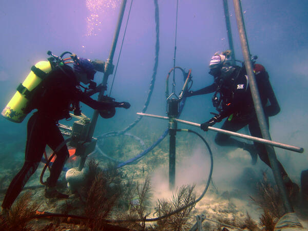
USGS scientists drill a coral-reef core in the Florida Keys
Research Oceanographer Lauren Toth and student volunteer Liz Whitcher drill a coral-reef core from a reef off Key West, Florida, in the Florida Keys National Marine Sanctuary. Photo taken under research permit FKNMS-2015-058. Credit: Anastasios Stathakopoulos, USGS.
Research Oceanographer Lauren Toth and student volunteer Liz Whitcher drill a coral-reef core from a reef off Key West, Florida, in the Florida Keys National Marine Sanctuary. Photo taken under research permit FKNMS-2015-058. Credit: Anastasios Stathakopoulos, USGS.

Sunrise at Jensen Beach, FL
A colorful sunrise appears over the horizon of a calm ocean offshore of Jensen Beach, Florida. USGS Scientist RC Mickey collects data for location and elevation of sea turtle crawls and associated beach profiles this stretch of coastline.
A colorful sunrise appears over the horizon of a calm ocean offshore of Jensen Beach, Florida. USGS Scientist RC Mickey collects data for location and elevation of sea turtle crawls and associated beach profiles this stretch of coastline.

Like many Keys corals, this one has no new growth
A modern coral reef in Dry Tortugas National Park. There is little living coral and high rates of bioerosion. Photo taken under research permit number DRTO-2018-SCI-0005. Credit: Lauren Toth, USGS
A modern coral reef in Dry Tortugas National Park. There is little living coral and high rates of bioerosion. Photo taken under research permit number DRTO-2018-SCI-0005. Credit: Lauren Toth, USGS

Relict Acropora palmata coral-reef framework in the Dry Tortugas
Acropora palmata coral-reef framework in the Dry Tortugas National Park, Florida Keys built more than 3000 years ago. That framework, which serves as the foundation for all of the critical ecosystem services reefs provide to society, is now rapidly eroding away.
Acropora palmata coral-reef framework in the Dry Tortugas National Park, Florida Keys built more than 3000 years ago. That framework, which serves as the foundation for all of the critical ecosystem services reefs provide to society, is now rapidly eroding away.

Relict Holocene coral-reef framework in the Dry Tortugas National Park
Relict Holocene coral-reef framework in the Florida Keys. Like many reefs in the western Atlantic, reefs here were just a few coral species: primary Acropora palmata and Orbicella spp. Recent disturbances have led to declines in the populations of those corals and relative increases in the abundance of more weedy taxa.
Relict Holocene coral-reef framework in the Florida Keys. Like many reefs in the western Atlantic, reefs here were just a few coral species: primary Acropora palmata and Orbicella spp. Recent disturbances have led to declines in the populations of those corals and relative increases in the abundance of more weedy taxa.

Driftwood on the edge of a sandy beach on Fire Island
Driftwood on the edge of a sandy beach, against the background of the Fire Island breach, with the other edge of the breach in the background.
Driftwood on the edge of a sandy beach, against the background of the Fire Island breach, with the other edge of the breach in the background.

Wilderness breach at Fire Island in 2018
Breaching of Fire Island, NY occurred during Hurricane Sandy in 2012 (Wilderness Breach). Wilderness Breach in 2018 as seen from a low angle, note the other side of breached island is in the distance.
Breaching of Fire Island, NY occurred during Hurricane Sandy in 2012 (Wilderness Breach). Wilderness Breach in 2018 as seen from a low angle, note the other side of breached island is in the distance.

Nearshore geophysical mapping
Nearshore geophysical mapping with sub-bottom sled (foreground), personal watercraft equipped with echosounders (background, water) and beach-based personnel (background, beach).
Nearshore geophysical mapping with sub-bottom sled (foreground), personal watercraft equipped with echosounders (background, water) and beach-based personnel (background, beach).

West view of Fire Island, New York from the Fire Island Lighthouse
The Coastal Sediment Availability and Flux project conducts research and monitoring of sediment movement and coastal change at several barrier islands around the U.S.
The Coastal Sediment Availability and Flux project conducts research and monitoring of sediment movement and coastal change at several barrier islands around the U.S.

USGS vessels and staff collecting geophysical data in the nearshore
USGS vessels and staff acquiring geophysical data in the nearshore. Collecting shoreface data in the water as close to the beach as possible is difficult with breaking waves. The USGS St. Petersburg Coastal and Marine Science Center adapted existing equipment for data collection in shallow water.
USGS vessels and staff acquiring geophysical data in the nearshore. Collecting shoreface data in the water as close to the beach as possible is difficult with breaking waves. The USGS St. Petersburg Coastal and Marine Science Center adapted existing equipment for data collection in shallow water.

Diadema antillarum, the long-spined sea urchin
Diadema antillarum, the long-spined sea urchin, is an ecologically important species in Caribbean coral reef habitats where it controls algal growth and coverage and helps keep reef surfaces clear for corals to grow and settle. In early 2022, the remaining D. antillarum populations began experiencing mass mortality in the Caribbean.
Diadema antillarum, the long-spined sea urchin, is an ecologically important species in Caribbean coral reef habitats where it controls algal growth and coverage and helps keep reef surfaces clear for corals to grow and settle. In early 2022, the remaining D. antillarum populations began experiencing mass mortality in the Caribbean.

R/V Sallenger and seismic sled used for sub-bottom surveying
A team of USGS scientists work off the R/V Sallenger in Rockaway Beach, New York. One team member stands on a floating sled that enables sub‐bottom surveying in shallow water, nearshore, and shore‐face environments. The sled is equipped with an EdgeTech SB‐512i CHIRP system and single‐beam sonar.
A team of USGS scientists work off the R/V Sallenger in Rockaway Beach, New York. One team member stands on a floating sled that enables sub‐bottom surveying in shallow water, nearshore, and shore‐face environments. The sled is equipped with an EdgeTech SB‐512i CHIRP system and single‐beam sonar.

Elkhorn coral on a USGS calcification assessment station, Dry Tortugas
Established in 2009, the U.S. Geological Survey’s Coral Assessment Network (USGS-CAN) provides data on coral-growth (calcification) rates throughout the Florida Keys. Pictured here is one of 30 stations located in in Dry Tortugas National Park.
Established in 2009, the U.S. Geological Survey’s Coral Assessment Network (USGS-CAN) provides data on coral-growth (calcification) rates throughout the Florida Keys. Pictured here is one of 30 stations located in in Dry Tortugas National Park.

Eroding marshes on the bay behind Long Beach Island, New Jersey
The remnants of an eroding marsh sit on a bayside beach behind Long Beach Island, New Jersey. Marsh loss and bayside erosion can be outcomes of both natural landscape evolution and human modification of coastal barrier systems.
The remnants of an eroding marsh sit on a bayside beach behind Long Beach Island, New Jersey. Marsh loss and bayside erosion can be outcomes of both natural landscape evolution and human modification of coastal barrier systems.