
Fire Island is a 50-km long barrier island along the south shore of Long Island, NY. The island is comprised of seventeen year-round communities; federal, state, and county parks; and supports distinct ecosystems alongside areas of economic and cultural value.
Images
Images intro.
Filter Total Items: 672

On-site data processing of geophysical data from Fire Island, New York
Fire Island is a 50-km long barrier island along the south shore of Long Island, NY. The island is comprised of seventeen year-round communities; federal, state, and county parks; and supports distinct ecosystems alongside areas of economic and cultural value.

Photo collage of images from Fire Island
Photo collage of images from Fire Island showing dunes and beaches
Photo collage of images from Fire Island showing dunes and beaches

Collecting a core from a reef
Two divers work to collect a long core sample from a coral reef in Florida.
Two divers work to collect a long core sample from a coral reef in Florida.

Aerial view of a southeast Louisiana coastal marsh
Aerial view of a southeast Louisiana coastal marsh.
Aerial view of a southeast Louisiana coastal marsh.

Seismic instrument on pontoon floats deployed from the beach
We mount our seismic instrument on pontoon floats with wheels. This setup is deployed from the beach and eventually towed behind our survey vessel.
We mount our seismic instrument on pontoon floats with wheels. This setup is deployed from the beach and eventually towed behind our survey vessel.

Illustration describes a barrier island from ocean to lagoon
Illustration shows the cross-section of a barrier island progressing from ocean (on the right) to marsh and then lagoon (on the left).
Illustration shows the cross-section of a barrier island progressing from ocean (on the right) to marsh and then lagoon (on the left).

Coastal wetland ecosystems in Jamaica Bay, New York,
Coastal wetland ecosystems in Jamaica Bay, New York, provide important ecosystem services along the highly urbanized Atlantic coast.
Coastal wetland ecosystems in Jamaica Bay, New York, provide important ecosystem services along the highly urbanized Atlantic coast.

Sea level rise scenario model for Dauphin Island, Alabama
This model shows what Dauphin Island, Alabama, may look like under moderate storms but with increasing rates of sea level rise (Passeri and others, 2018).
This model shows what Dauphin Island, Alabama, may look like under moderate storms but with increasing rates of sea level rise (Passeri and others, 2018).
Storm and sea level rise scenario model for Dauphin Island, Alabama
Storm and sea level rise scenario models, like the one shown here, can be used to explore the future. This model shows what Dauphin Island may look like 10 years from now if storms become stronger and more frequent (Passeri and others, 2018).
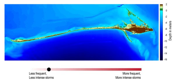
Storm and sea level rise scenario models, like the one shown here, can be used to explore the future. This model shows what Dauphin Island may look like 10 years from now if storms become stronger and more frequent (Passeri and others, 2018).

Deployment of the chirp seismic instrument from the beach
Most underwater seismic data is collected from large research vessels; however, the shoreface environment is shallower than areas in which most seismic surveys occur. To get the information we need to assess changes in shoreface geology, we mount our seismic instruments on pontoon floats and deploy the instrument from the beach.
Most underwater seismic data is collected from large research vessels; however, the shoreface environment is shallower than areas in which most seismic surveys occur. To get the information we need to assess changes in shoreface geology, we mount our seismic instruments on pontoon floats and deploy the instrument from the beach.

USGS aerial imaging mapping team
USGS unmanned aerial system (uas) mapping team on the beach in Dauphin Island, Alabama
USGS unmanned aerial system (uas) mapping team on the beach in Dauphin Island, Alabama

Perspective lidar view of coastal bathymetry at St. Thomas, USVI
Perspective view of coastal bathymetry looking onshore, St. Thomas, US Virgin Islands, mapped using lidar and depicted with false-color, showing detailed submerged features, including coral reefs.
Perspective view of coastal bathymetry looking onshore, St. Thomas, US Virgin Islands, mapped using lidar and depicted with false-color, showing detailed submerged features, including coral reefs.

Dr. Christina Kellogg loads coral samples for DNA extraction
SPCMSC Research Microbiologist Christina Kellogg loading coral samples into an automated DNA extraction instrument for processing.
SPCMSC Research Microbiologist Christina Kellogg loading coral samples into an automated DNA extraction instrument for processing.

Dauphin Island, Alabama
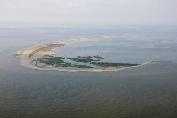
A view of a vegetated inland coastline overlooking the water on Dauphin Island, Alabama. The island protects mainland Alabama’s coastal communities and resources from storms, while also providing recreational opportunities (fishing, beach tourism, etc.) and other economic benefits to the local community and state.
A view of a vegetated inland coastline overlooking the water on Dauphin Island, Alabama. The island protects mainland Alabama’s coastal communities and resources from storms, while also providing recreational opportunities (fishing, beach tourism, etc.) and other economic benefits to the local community and state.

Dauphin Island, Alabama
A panoramic view on Dauphin Island, Alabama. The island protects mainland Alabama’s coastal communities and resources from storms, while also providing recreational opportunities (fishing, beach tourism, etc.) and other economic benefits to the local community and state.
A panoramic view on Dauphin Island, Alabama. The island protects mainland Alabama’s coastal communities and resources from storms, while also providing recreational opportunities (fishing, beach tourism, etc.) and other economic benefits to the local community and state.
Aerial photograph looking southwest along Breton Island, Louisiana
Aerial photograph looking southwest along Breton Island, Louisiana, taken July 2013
Aerial photograph looking southwest along Breton Island, Louisiana, taken July 2013

USGS researchers ride along the dune; Kennedy Space Center in distance
The USGS collaborates with NASA, the University of Florida, National Park Service, and the U.S. Fish and Wildlife Service to assess coastal erosion hazards affecting space program infrastructure, habitat, and wildlife populations.
The USGS collaborates with NASA, the University of Florida, National Park Service, and the U.S. Fish and Wildlife Service to assess coastal erosion hazards affecting space program infrastructure, habitat, and wildlife populations.

Point aux Chênes, Mississippi marsh push core
A short marsh push core, exhibiting a sandy event layer on top, collected from Point aux Chênes, Mississippi marsh during sample collection in October 2018 for sediment and radiochemical analyses.
A short marsh push core, exhibiting a sandy event layer on top, collected from Point aux Chênes, Mississippi marsh during sample collection in October 2018 for sediment and radiochemical analyses.

Point aux Chênes, Mississippi marsh shoreline
Looking south along the Point aux Chênes, Mississippi marsh shoreline during sample collection in October 2018; sediment probe located at the shoreline is used to assist in aligning sample collection along shore perpendicular transect.
Looking south along the Point aux Chênes, Mississippi marsh shoreline during sample collection in October 2018; sediment probe located at the shoreline is used to assist in aligning sample collection along shore perpendicular transect.

Coral cores like this one reveal geologic history of Keys reefs
USGS Research Oceanographer Lauren Toth and Oceanographer Anastasios Stathakopoulos study a coral-reef core in the USGS’s Core Archive in St. Petersburg, Florida. Photo: Dominique Gallery, USGS.
USGS Research Oceanographer Lauren Toth and Oceanographer Anastasios Stathakopoulos study a coral-reef core in the USGS’s Core Archive in St. Petersburg, Florida. Photo: Dominique Gallery, USGS.

Andrea "Andy" O'Neill in Monterey
“The ocean is the closest I can get to an unexplored world, without going into space... I mean, I feel a deep connection to the ocean and its constant rhythms, but when I visit, there's a new discovery or appreciation every time.
“The ocean is the closest I can get to an unexplored world, without going into space... I mean, I feel a deep connection to the ocean and its constant rhythms, but when I visit, there's a new discovery or appreciation every time.