
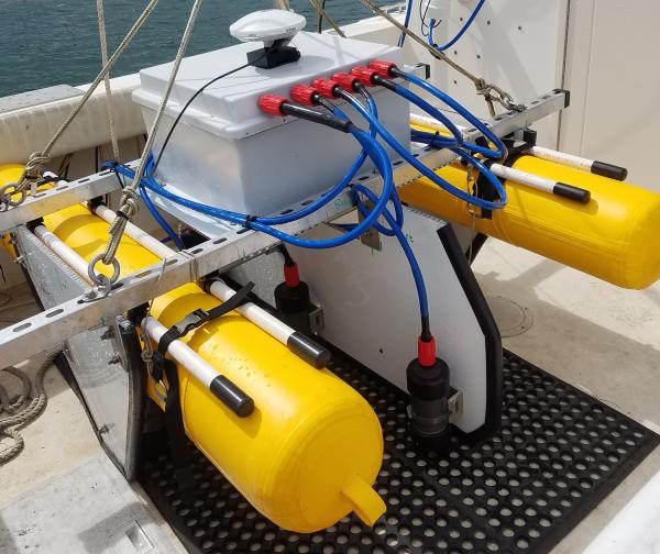
USGS researchers Chris Moore and Mitchell Lemon took a trip on the R/V Weatherbird in January of 2020 with the University of South Florida College of Marine Science as part of a study on carbon dioxide in the Gulf of Mexico. Carbon Dioxide, or CO2, is a greenhouse gas that can be absorbed by the ocean.
Images
Images intro.
Filter Total Items: 672

Deploying anchor chain for an oceanographic buoy
USGS researchers Chris Moore and Mitchell Lemon took a trip on the R/V Weatherbird in January of 2020 with the University of South Florida College of Marine Science as part of a study on carbon dioxide in the Gulf of Mexico. Carbon Dioxide, or CO2, is a greenhouse gas that can be absorbed by the ocean.

Various clues determine reliable coral samples
This piece of a core sample taken from offshore of the Fort Lauderdale region of Florida is from an elkhorn coral that lived 6,200 years ago. Coral type, orientation of corallites, and evidence of other fauna and characteristics within the core sample are used to determine how reliable the coral sample is to use for past sea-level reconstruction.
This piece of a core sample taken from offshore of the Fort Lauderdale region of Florida is from an elkhorn coral that lived 6,200 years ago. Coral type, orientation of corallites, and evidence of other fauna and characteristics within the core sample are used to determine how reliable the coral sample is to use for past sea-level reconstruction.

Coral-reef core from the USGS core archive
This core sample was taken from an elkhorn coral reef offshore of the Fort Lauderdale region of Florida. Samples from coral skeletons are taken from numerous locations in the core for radiocarbon dating, which tells scientists the age of each coral and of sections within the reef. The corals in this core lived from 7,100 to 6,200 years ago.
This core sample was taken from an elkhorn coral reef offshore of the Fort Lauderdale region of Florida. Samples from coral skeletons are taken from numerous locations in the core for radiocarbon dating, which tells scientists the age of each coral and of sections within the reef. The corals in this core lived from 7,100 to 6,200 years ago.
SQUID-5 - Structure-from-Motion Quantitative Underwater Imaging Device
The SQUID-5, or a Structure-from-Motion (SfM) Quantitative Underwater Imaging Device with 5 cameras is a towed surface vehicle with an onboard Global Navigation Satellite System (GNSS) and 5 downward-looking cameras with overlapping views of the seafloor.
The SQUID-5, or a Structure-from-Motion (SfM) Quantitative Underwater Imaging Device with 5 cameras is a towed surface vehicle with an onboard Global Navigation Satellite System (GNSS) and 5 downward-looking cameras with overlapping views of the seafloor.

Stained Glass Commemorating Abby Sallenger
In 2015, artist Lenn Neff dedicated this stained-glass artwork commemorating Dr. Abby Sallenger, former Center Director of SPCMSC. The glass now resides in the main hall of the Getting building, facing the courtyard.
In 2015, artist Lenn Neff dedicated this stained-glass artwork commemorating Dr. Abby Sallenger, former Center Director of SPCMSC. The glass now resides in the main hall of the Getting building, facing the courtyard.

A wave breaks over a degraded reef crest at Buck Island in St. Croix
A wave breaking over a degraded reef crest at Buck Island National Monument in St. Croix. Wave-breaking in these habitats relies on reef framework built by the elkhorn coral, Acropora palmata, which is now a threatened species throughout the western Atlantic.
A wave breaking over a degraded reef crest at Buck Island National Monument in St. Croix. Wave-breaking in these habitats relies on reef framework built by the elkhorn coral, Acropora palmata, which is now a threatened species throughout the western Atlantic.

Studebaker building, 2020
This historic Studebaker building is the home of the St. Petersburg Coastal and Marine Science Center.
Learn more about the history of the St. Petersburg Coastal and Marine Science Center.
This historic Studebaker building is the home of the St. Petersburg Coastal and Marine Science Center.
Learn more about the history of the St. Petersburg Coastal and Marine Science Center.

Studebaker Building and Young Building at SPCMSC
Construction of the Young building at the St. Petersburg Coastal and Marine Science Center began in 2002. The newest building of SPCMSC encompasses an area of 11,400 ft2 and features six state-of-the-art laboratories, a dive locker, and 12 additional offices. Dedicated in March 2008, the third building is the latest addition to the C.W.
Construction of the Young building at the St. Petersburg Coastal and Marine Science Center began in 2002. The newest building of SPCMSC encompasses an area of 11,400 ft2 and features six state-of-the-art laboratories, a dive locker, and 12 additional offices. Dedicated in March 2008, the third building is the latest addition to the C.W.

USGS St. Petersburg Studebaker Building
This historic brick Studebaker Building, originally built in 1925, was chosen as the location for the USGS St. Petersburg Coastal and Marine Science Center in the late 1980s.
This historic brick Studebaker Building, originally built in 1925, was chosen as the location for the USGS St. Petersburg Coastal and Marine Science Center in the late 1980s.

Bust and stained-glass art dedicated to C.W. Bill Young
Bust and stained-glass art dedicated to C.W. Bill Young in 2002. This dedication stands in the Breezeway between the Studebaker and Getting buildings at the USGS St. Petersburg Coastal and Marine Science Center.
Bust and stained-glass art dedicated to C.W. Bill Young in 2002. This dedication stands in the Breezeway between the Studebaker and Getting buildings at the USGS St. Petersburg Coastal and Marine Science Center.

Cliff Feature Delineation Tool Outputs in Malibu, California
Digital three-dimensional rendering of the coastal cliffs around Point Dume in Malibu, California. Cliff feature outputs from the Cliff Feature Delineation Tool are shown to conceptually display the cliff delineation process, including cross-shore transects (green), the cliff top line (red), the cliff toe line (blue), and subsidiary cliff features (orange).
Digital three-dimensional rendering of the coastal cliffs around Point Dume in Malibu, California. Cliff feature outputs from the Cliff Feature Delineation Tool are shown to conceptually display the cliff delineation process, including cross-shore transects (green), the cliff top line (red), the cliff toe line (blue), and subsidiary cliff features (orange).

squid-5StudyAreaMap.jpg
Image map of study area showing (a) study region, (b) study sites, (c, d) example orthomosaic images, and (e) photo of SET 1.
Image map of study area showing (a) study region, (b) study sites, (c, d) example orthomosaic images, and (e) photo of SET 1.

UAS flying on a beach
A pilot flying a UAS on the beach.
A pilot flying a UAS on the beach.

Modern coral reef dominated by weedy coral species
A coral reef in the Turks and Caicos Islands dominated by the weedy coral species, Porites astreoides. The relative dominance of this taxa has increased throughout the western Atlantic.
A coral reef in the Turks and Caicos Islands dominated by the weedy coral species, Porites astreoides. The relative dominance of this taxa has increased throughout the western Atlantic.

A photo of a National Park Service information plate
A photo of a National Park Service information plate on “Sharks in Cape Cod Waters”, Cape Cod, MA, taken during a field study reconnaissance mission.
A photo of a National Park Service information plate on “Sharks in Cape Cod Waters”, Cape Cod, MA, taken during a field study reconnaissance mission.
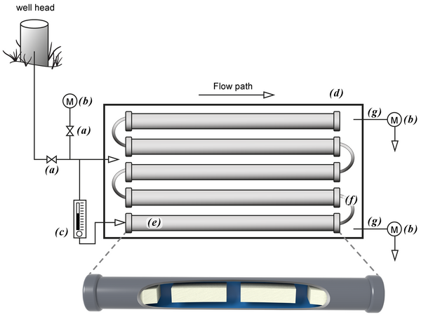
Above ground mesocosm with biofilm growth reactors
Above ground mesocosm with biofilm growth reactors. Groundwater from the well head is directly transferred to the mesocosm via PTFE tubing into a high flow rate control valve (a) that diverts groundwater into a flow cell containing a water quality measurement meter (b) and a low flow control valve (c).
Above ground mesocosm with biofilm growth reactors. Groundwater from the well head is directly transferred to the mesocosm via PTFE tubing into a high flow rate control valve (a) that diverts groundwater into a flow cell containing a water quality measurement meter (b) and a low flow control valve (c).

Research activities performed by Coastal and Marine scientists
Coastal and Marine scientists collect data in the field.
Coastal and Marine scientists collect data in the field.

Map showing rates of shoreline change on the north coast of Alaska
Map showing rates of shoreline change on the north coast of Alaska. Rates range from -15 meters per year to +11 meters per year.
Map showing rates of shoreline change on the north coast of Alaska. Rates range from -15 meters per year to +11 meters per year.

Seagull on Indian Rocks Beach, Florida
Seagull on Indian Rocks Beach, Florida
Seagull on Indian Rocks Beach, Florida

On board the IODP vessel JOIDES Resolution
Several instruments visible on board the research vessel JOIDES Resolution. Photo taken from the ship bridge roof. USGS logo visible on one of the pieces of equipment. Research cruises taken on the JOIDES Resolution are often interdisciplinary and collaborative across many universities, scientific agencies, and other research institutions.
Several instruments visible on board the research vessel JOIDES Resolution. Photo taken from the ship bridge roof. USGS logo visible on one of the pieces of equipment. Research cruises taken on the JOIDES Resolution are often interdisciplinary and collaborative across many universities, scientific agencies, and other research institutions.

USGS and National Park Service partner on coral growth study
Glenn Simpson (left), Park Manager of the Dry Tortugas National Park, National Park Service and Ilsa Kuffner (right), USGS Research Marine Biologist, with an elkhorn coral from Pulaski Shoal being weighed and measured.
Glenn Simpson (left), Park Manager of the Dry Tortugas National Park, National Park Service and Ilsa Kuffner (right), USGS Research Marine Biologist, with an elkhorn coral from Pulaski Shoal being weighed and measured.