
Scientific divers BJ Reynolds and Hunter Wilcox prepare to lower an Acoustic Doppler Current Profiler (ADCP) into the water. The ADCP now sits on the bottom of the ocean off Madeira beach, Florida in 5m water depth.
Images
Images intro.
Filter Total Items: 672

Divers prepare to deploy ADCP
Scientific divers BJ Reynolds and Hunter Wilcox prepare to lower an Acoustic Doppler Current Profiler (ADCP) into the water. The ADCP now sits on the bottom of the ocean off Madeira beach, Florida in 5m water depth.

Inlet geomorphic environments with sediment transport pathways
Inlet geomorphic environments with sediment transport pathways indicated by black arrows.
Inlet geomorphic environments with sediment transport pathways indicated by black arrows.
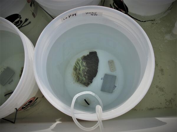
Testing the role of biofilms in the spread of stony coral tissue loss disease (SCTLD)
Biofilms are mats of microorganisms that stick together and form a layer, or “film,” on and within objects in the water—including ships—which could represent one possible mechanism for the spread of microbes (and potentially SCTLD’s unknown causative agent) from one region to another. To test this theory, scientists at the St.
Biofilms are mats of microorganisms that stick together and form a layer, or “film,” on and within objects in the water—including ships—which could represent one possible mechanism for the spread of microbes (and potentially SCTLD’s unknown causative agent) from one region to another. To test this theory, scientists at the St.

Gamma detectors at the St. Petersburg Coastal & Marine Science Center
Radioactive isotopes are common in nature and emit particles that can be detected, quantified, and used to characterize environmental processes.
Radioactive isotopes are common in nature and emit particles that can be detected, quantified, and used to characterize environmental processes.

Aerial view of northern Pinellas County barrier islands
Barrier islands off the coast of northern Pinellas County, Florida including Anclote Key, Three Rooker Island, and the northern tip of Honeymoon Island. These barriers protect a highly populated coastline.
Barrier islands off the coast of northern Pinellas County, Florida including Anclote Key, Three Rooker Island, and the northern tip of Honeymoon Island. These barriers protect a highly populated coastline.

Succession of beach ridges, Caladesi Island, Gulf of Mexico coast, FL
Mendenhall postdoctoral fellow Daniel Ciarletta captured this view of the modern beach ridge system at Caladesi Island, along the Gulf coast of central Florida. Ciarletta and colleagues are studying the island as part of a project to explore barrier island response to long-term changes in sediment availability.
Mendenhall postdoctoral fellow Daniel Ciarletta captured this view of the modern beach ridge system at Caladesi Island, along the Gulf coast of central Florida. Ciarletta and colleagues are studying the island as part of a project to explore barrier island response to long-term changes in sediment availability.

Using personal watercraft to collect nearshore bathymetry data
A USGS scientist sits on a personal watercraft (PWC) equipped with scientific equipment to collect bathymetry data - or the depth of the water - at locations of interest in Point Aux Chenes Bay, Mississippi.
A USGS scientist sits on a personal watercraft (PWC) equipped with scientific equipment to collect bathymetry data - or the depth of the water - at locations of interest in Point Aux Chenes Bay, Mississippi.

Dr. Mark Buckley holds a buoy used to collect oceanographic data
Dr. Mark Buckley of the USGS St. Petersburg Coastal and Marine Science Center holds a new Sofar Smart Mooring and Spotter Buoy that will be used to deliver high-fidelity, real-time wave, water level, and wind data.
Dr. Mark Buckley of the USGS St. Petersburg Coastal and Marine Science Center holds a new Sofar Smart Mooring and Spotter Buoy that will be used to deliver high-fidelity, real-time wave, water level, and wind data.

Sediment Sample from Barrier Island Core
Daniel Ciarletta, Ph.D. holds a chunk of sand from the bottom of a core collected at Fort de Soto Park in Pinellas County, Florida. Learn more about what barrier island cores tell us: https://www.usgs.gov/media/videos/secrets-sediment-barrier-islands.
Daniel Ciarletta, Ph.D. holds a chunk of sand from the bottom of a core collected at Fort de Soto Park in Pinellas County, Florida. Learn more about what barrier island cores tell us: https://www.usgs.gov/media/videos/secrets-sediment-barrier-islands.

Collecting sediment core with vibracore equipment at Mullet Key, FL
Dan Ciarletta (right) working alongside Julie Bernier (left) to collect a sediment core on Mullet Key, an island within Fort de Soto Park in Pinellas County, Florida. The core will be used to reconstruct the geologic history of the island.
Dan Ciarletta (right) working alongside Julie Bernier (left) to collect a sediment core on Mullet Key, an island within Fort de Soto Park in Pinellas County, Florida. The core will be used to reconstruct the geologic history of the island.


Helikite Surveying
The Helikite in action, being walked by USGS scientist Chris Sherwood and WHOI scientist Peter Traykovski, the helium powered balloon kite will be used to survey the DUNEX experiment site.
The Helikite in action, being walked by USGS scientist Chris Sherwood and WHOI scientist Peter Traykovski, the helium powered balloon kite will be used to survey the DUNEX experiment site.

Surveying the Beach at Caladesi Island, Gulf of Mexico Coast, Florida
Mendenhall postdoctoral fellow Daniel Ciarletta and geologist Julie Bernier perform field reconnaissance at Caladesi Island, along the Gulf coast of central Florida. The scientists are refining a plan to sample and survey the island using sediment vibracores and ground-penetrating radar.
Mendenhall postdoctoral fellow Daniel Ciarletta and geologist Julie Bernier perform field reconnaissance at Caladesi Island, along the Gulf coast of central Florida. The scientists are refining a plan to sample and survey the island using sediment vibracores and ground-penetrating radar.

USGS technician holding a bottle containing a sediment sample
Hydrologic Technician Alan Cressler holding a bottle containing a sediment sample. Photo taken on the Caloosahatchee River below Structure 77, Moore Haven, Florida.
Hydrologic Technician Alan Cressler holding a bottle containing a sediment sample. Photo taken on the Caloosahatchee River below Structure 77, Moore Haven, Florida.

USGS scuba diver on a coral reef in Dry Tortugas National Park
The U.S. Geological Survey is conducting research to guide the recovery of the threatened Elkhorn coral, Acropora palmata, in Dry Tortugas National Park and throughout the western Atlantic.
The U.S. Geological Survey is conducting research to guide the recovery of the threatened Elkhorn coral, Acropora palmata, in Dry Tortugas National Park and throughout the western Atlantic.

Wave conditions and probability of burial during munitions experiment
A) Conditions during a 2015 munitions mobility experiment in Duck, NC, and B) cartographic visualization of hindcast probability of munitions’ complete burial during the experiment.
A) Conditions during a 2015 munitions mobility experiment in Duck, NC, and B) cartographic visualization of hindcast probability of munitions’ complete burial during the experiment.

Experimental elkhorn coral in Dry Tortugas National Park
The U.S. Geological Survey St. Petersburg Coastal and Marine Science Center is conducting research to guide the restoration and recovery of the threatened elkhorn coral, Acropora palmata, in Dry Tortugas National Park and throughout the western Atlantic.
The U.S. Geological Survey St. Petersburg Coastal and Marine Science Center is conducting research to guide the restoration and recovery of the threatened elkhorn coral, Acropora palmata, in Dry Tortugas National Park and throughout the western Atlantic.

Deploying the Autonomous Surf Vehicle at Pea Island
The USGS will be using an autonomous surf vehicle, built by Peter Traykovski of WHOI, to map the bathymetry of the Pea Island DUNEX Experiment Site.
The USGS will be using an autonomous surf vehicle, built by Peter Traykovski of WHOI, to map the bathymetry of the Pea Island DUNEX Experiment Site.

Autonomous Surf Vehicle in Action
The autonomous surf vehicle, built and controlled remotely by Peter Traykovski of WHOI, is used to map the bathymetry of the Pea Island DUNEX Experiment Site.
The autonomous surf vehicle, built and controlled remotely by Peter Traykovski of WHOI, is used to map the bathymetry of the Pea Island DUNEX Experiment Site.