
At Mount Baker, Washington, observers noted continuing landslide activity in the upper Middle Fork Nooksack drainage that resulted in small debris flows and muddy floods. Scientists from multiple agencies and institutions coordinated observations, surveying, and sampling to gain an understanding of the situation.
Images
Images intro.
Filter Total Items: 7147

Measuring turbidity in streams near Mount Baker, WA.
At Mount Baker, Washington, observers noted continuing landslide activity in the upper Middle Fork Nooksack drainage that resulted in small debris flows and muddy floods. Scientists from multiple agencies and institutions coordinated observations, surveying, and sampling to gain an understanding of the situation.

Kahauale‘a 2 flow margin at the forest boundary
A wider view of a portion of the Kahauale‘a 2 flow margin at the forest boundary.
A wider view of a portion of the Kahauale‘a 2 flow margin at the forest boundary.

eastern ocean entry at Kupapa‘u Point. Just inland from the entry ...
This thermal image shows the eastern ocean entry at Kupapa‘u Point. Just inland from the entry point a patch of slightly warmer temperatures indicates an area of recent small breakouts.
This thermal image shows the eastern ocean entry at Kupapa‘u Point. Just inland from the entry point a patch of slightly warmer temperatures indicates an area of recent small breakouts.

Kahauale‘a flow — Cone producing lava
The Kahauale‘a 2 flow, which is active north of Pu‘u ‘Ō‘ō, is fed from a vent at this cone on the northeast rim of Pu‘u ‘Ō‘ō crater. Small openings at the top of the cone contain sloshing lava, and two skylights at the very start of the Kahauale‘a 2 lava tube provided views of a swiftly moving lava stream rushing downslope.
The Kahauale‘a 2 flow, which is active north of Pu‘u ‘Ō‘ō, is fed from a vent at this cone on the northeast rim of Pu‘u ‘Ō‘ō crater. Small openings at the top of the cone contain sloshing lava, and two skylights at the very start of the Kahauale‘a 2 lava tube provided views of a swiftly moving lava stream rushing downslope.

Lava flow from Kīlauea (Hawaii) enters forest.
On Kīlauea's East Rift Zone, the Kahauale'a 2 flow advances slowly into the Puna Forest Reserve. The Kahauale`a 2 flow began in early May, 2013, on the north side of the rift.
On Kīlauea's East Rift Zone, the Kahauale'a 2 flow advances slowly into the Puna Forest Reserve. The Kahauale`a 2 flow began in early May, 2013, on the north side of the rift.
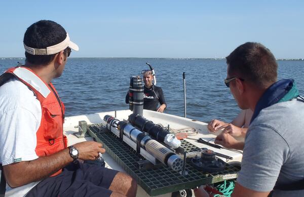
Shallow Water Irradience Platform placement in Barnegat Bay, NJ
Investigators prepare to place a Shallow Water Irradience Platform (SWIP) at a site in Barnegat Bay, NJ.
Investigators prepare to place a Shallow Water Irradience Platform (SWIP) at a site in Barnegat Bay, NJ.

Salt Marsh Research
USGS research supports wetland conservation as critical habitat, Cape Cod, MA
USGS research supports wetland conservation as critical habitat, Cape Cod, MA

USGS and Summer Interns from the Partnership Education Program (PEP) p
USGS and Summer Interns from the Partnership Education Program (PEP) program sampling over a tidal cycle.
USGS and Summer Interns from the Partnership Education Program (PEP) program sampling over a tidal cycle.

Carbon dioxide gas detection Horseshoe Lake, Mammoth Mountain, CA.
Carbon dioxide gas detection instrument installed at Horseshoe Lake, Mammoth Mountain, California.
Carbon dioxide gas detection instrument installed at Horseshoe Lake, Mammoth Mountain, California.

Equipment used for a measuring lateral fluxes over tidal cycle
Equipment used for a measuring lateral fluxes over tidal cycle
Equipment used for a measuring lateral fluxes over tidal cycle

Teachers take a guided walk on the Hummocks Trail at Mount St. Helens
Teachers take a guided walk on the Hummocks Trail, learning about the depositional features of the May 18, 1980 eruption.
Teachers take a guided walk on the Hummocks Trail, learning about the depositional features of the May 18, 1980 eruption.

Teachers learn about hummocks at Mount St. Helens workshop.
Todd Cullings, with the Mount St. Helens National Volcanic Monument, leads teachers in activities they can do with students before hiking the Hummocks Trail.
Todd Cullings, with the Mount St. Helens National Volcanic Monument, leads teachers in activities they can do with students before hiking the Hummocks Trail.

Flooding on Hidewood Creek near Estelline, SD
Localized flooding on Hidewood Creek near Estelline, SD, on June 23, 2013. Severe storms during June 21-22, 2013, in eastern South Dakota resulted in high flows in several streams across the area. The peak discharge on Hidewood Creek (streamgage 06479640) from this storm event was about 4,200 cubic feet per second.
Localized flooding on Hidewood Creek near Estelline, SD, on June 23, 2013. Severe storms during June 21-22, 2013, in eastern South Dakota resulted in high flows in several streams across the area. The peak discharge on Hidewood Creek (streamgage 06479640) from this storm event was about 4,200 cubic feet per second.

If a picture is worth a thousand words, a geologic map is priceless
This geologic map of Mauna Loa shows surface flows that have been mapped as of 2013. The flows are color-coded to reflect age. Warm colors indicate younger flows, with red indicating flows erupted since 1832.
This geologic map of Mauna Loa shows surface flows that have been mapped as of 2013. The flows are color-coded to reflect age. Warm colors indicate younger flows, with red indicating flows erupted since 1832.

Mw6.6 Lushan China Earthquake, April 20 2013
Damage to a village house.
Damage to a village house.

Mw6.6 Lushan China Earthquake, April 20 2013
Damage to a village house.
Damage to a village house.

Mw6.6 Lushan China Earthquake, April 20 2013
Damage to a local school building. Guozhang Middle School.
Damage to a local school building. Guozhang Middle School.

Mw6.6 Lushan China Earthquake, April 20 2013
Damage to a local school building. Guozhang Middle School.
Damage to a local school building. Guozhang Middle School.

Mw6.6 Lushan China Earthquake, April 20 2013
Total collapse of a reinforced building with masonry infill walls. Rubble has been disturbed by heavy equipment.
Total collapse of a reinforced building with masonry infill walls. Rubble has been disturbed by heavy equipment.

Mw6.6 Lushan China Earthquake, April 20 2013
Landslide in the earthquake.
Landslide in the earthquake.

Mw6.6 Lushan China Earthquake, April 20 2013
Students having class in temporary movable plank houses.
Students having class in temporary movable plank houses.