
As part of the Remote Sensing of Coastal Change and Florence Supplemental projects we have been developing novel workflows for repeat-mapping of coastal environments at order decimeter resolution over up to hundreds of kilometers in a single day, using Structure-from-Motion photogrammetry or SfM, from crewed aerial platforms.
Images
Explore our planet through photography and imagery, including climate change and water all the way back to the 1800s when the USGS was surveying the country by horse and buggy.
Filter Total Items: 21558

Fort Funston Structure-from-Motion point clouds
As part of the Remote Sensing of Coastal Change and Florence Supplemental projects we have been developing novel workflows for repeat-mapping of coastal environments at order decimeter resolution over up to hundreds of kilometers in a single day, using Structure-from-Motion photogrammetry or SfM, from crewed aerial platforms.

Geologic Map and Borehole Stratigraphy of Hinkley Valley and Vicinity,
Hinkley Valley, in the central to western Mojave Desert of southeastern California, has a long historical record owing to its position as a crossroads for rail and road traffic and its position adjacent to the Mojave River.
Hinkley Valley, in the central to western Mojave Desert of southeastern California, has a long historical record owing to its position as a crossroads for rail and road traffic and its position adjacent to the Mojave River.

Group of adult and immature Western Gulls (Larus occidentalis)
Zoomed image of a group of adult and immature Western Gulls (Larus occidentalis).
Zoomed image of a group of adult and immature Western Gulls (Larus occidentalis).
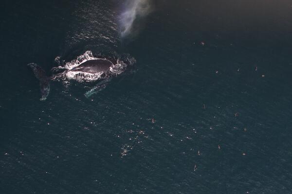
Humpback Whale and shearwaters feeding in southern California
Zoomed image of a Humpback Whale (Megaptera novaeangliae) and a group of shearwaters feeding in southern California.
Zoomed image of a Humpback Whale (Megaptera novaeangliae) and a group of shearwaters feeding in southern California.

Hydrologic Technician measures discharge in Ashwaubenon Creek, WI
Hydrologic Technician Matt Bach measures discharge in Ashwaubenon Creek near Little Rapids, WI (NWIS site: 04085068) on May 21, 2020, as part of a cooperative project with NEWWater (Green Bay Metropolitan Sewage District) utilizing an adaptive management approach to meet phosp
Hydrologic Technician Matt Bach measures discharge in Ashwaubenon Creek near Little Rapids, WI (NWIS site: 04085068) on May 21, 2020, as part of a cooperative project with NEWWater (Green Bay Metropolitan Sewage District) utilizing an adaptive management approach to meet phosp

Hydrologic Technician measures discharge in Ashwaubenon Creek, WI (2)
Hydrologic Technician Matt Bach measures discharge in Ashwaubenon Creek near Little Rapids, WI (NWIS site: 04085068) on May 21, 2020, as part of a cooperative project with NEWWater (Green Bay Metropolitan Sewage District) utilizing an adaptive management approach to meet phosp
Hydrologic Technician Matt Bach measures discharge in Ashwaubenon Creek near Little Rapids, WI (NWIS site: 04085068) on May 21, 2020, as part of a cooperative project with NEWWater (Green Bay Metropolitan Sewage District) utilizing an adaptive management approach to meet phosp

Hydrologist downloading water-level sensor deployed for summer
Hydrologist downloading water-level sensor deployed for summer as part of an ecohydro study in *H.J. Andrews Experimental Forest. *USGS Integrated Ecohydrological Science - USFS & Oregon State University *Patrick Haluska
Hydrologist downloading water-level sensor deployed for summer as part of an ecohydro study in *H.J. Andrews Experimental Forest. *USGS Integrated Ecohydrological Science - USFS & Oregon State University *Patrick Haluska

Images of tephra from Kīlauea’s newest eruption, collected 12/21/2020
Left: magnified view of erupted material, including Pele’s hair and tears, as seen under a microscope (USGS Photo by K. Lynn on 12/26/2020). Middle: Zoomed in electron image of the tephra, where greyscale indicates the relative abundance of iron (Fe).
Left: magnified view of erupted material, including Pele’s hair and tears, as seen under a microscope (USGS Photo by K. Lynn on 12/26/2020). Middle: Zoomed in electron image of the tephra, where greyscale indicates the relative abundance of iron (Fe).

Jeniffer Soto Perez(left) and Emily Richardson (Right) prepare samples
Jeniffer Soto Perez (left) and Emily Richardson (Right) prepare water quality sample bottles onboard the RV Landsteiner during a high-resolution water quality mapping survey.
Jeniffer Soto Perez (left) and Emily Richardson (Right) prepare water quality sample bottles onboard the RV Landsteiner during a high-resolution water quality mapping survey.

Katy O’Donnell monitors readings from water quality instrument
Katy O’Donnell monitors readings from different instruments of the flow-through system during a high-resolution water quality mapping survey onboard the RV Landsteiner along the Sacramento River in West Sacramento, CA.
Katy O’Donnell monitors readings from different instruments of the flow-through system during a high-resolution water quality mapping survey onboard the RV Landsteiner along the Sacramento River in West Sacramento, CA.

Katy O’Donnell onboard the RV Landsteiner during a survey
Katy O’Donnell onboard the RV Landsteiner during a high-resolution water quality mapping survey. The boat is equipped with a flow-through system that pumps water onto the boat while underway and directs sample water to a multiparameter water quality sonde, thermosalinograph, fluorometers, nitrate and ammonium analyzers.
Katy O’Donnell onboard the RV Landsteiner during a high-resolution water quality mapping survey. The boat is equipped with a flow-through system that pumps water onto the boat while underway and directs sample water to a multiparameter water quality sonde, thermosalinograph, fluorometers, nitrate and ammonium analyzers.

Kīlauea west vent on December 31, 2020, morning
The western fissure in Halemaʻumaʻu wall remains active. Glowing vents and a prominent spatter cone are visible in this photo, which shows some spattering at the vent. This view looks steeply down from Kīlauea's west caldera rim, and the lava lake surface is visible in the background. USGS photo by B. Carr on 12/31/2020.
The western fissure in Halemaʻumaʻu wall remains active. Glowing vents and a prominent spatter cone are visible in this photo, which shows some spattering at the vent. This view looks steeply down from Kīlauea's west caldera rim, and the lava lake surface is visible in the background. USGS photo by B. Carr on 12/31/2020.

Rebecca Steinberg making her first discharge measurement as a new hire
Rebecca Steinberg making her first discharge measurement as a new hydrologic technician while lake-effect snow creates a winter wonderland at the Cuyahoga River, Hiram Ohio gage station 04202000. An American flag is peaking out in the background.
Rebecca Steinberg making her first discharge measurement as a new hydrologic technician while lake-effect snow creates a winter wonderland at the Cuyahoga River, Hiram Ohio gage station 04202000. An American flag is peaking out in the background.

Small terns in flight
Zoomed image of small terns in flight.
Zoomed image of small terns in flight.

SQUID-5 Towed Surface Vehicle
Diagram of the SQUID-5 towed surface vehicle and the waterproof camera housings with labeled components. The camera mounting mechanism aligns the camera axially with the dome and allows the camera to be adjusted fore and aft to accommodate various lens types and enable alignment with the glass port radius of curvature for minimal distortion.
Diagram of the SQUID-5 towed surface vehicle and the waterproof camera housings with labeled components. The camera mounting mechanism aligns the camera axially with the dome and allows the camera to be adjusted fore and aft to accommodate various lens types and enable alignment with the glass port radius of curvature for minimal distortion.

USGS 401723105400000 ANDREWS CREEK - LOCH, VALE-Rocky Mountains

USGS employee taking surface water measurement at gage 11453500, CA
USGS employee taking surface water measurement at gage 11453500 Putah Creek near Guenoc, CA
USGS employee taking surface water measurement at gage 11453500 Putah Creek near Guenoc, CA

USGS staff collecting water samples from the catwalk on Conowingo Dam
USGS staff Dave Brower and Jeff Klein collecting water samples from the catwalk on Conowingo Dam. Streamgage 01578310 Susquehanna River at Conowingo, MD
USGS staff Dave Brower and Jeff Klein collecting water samples from the catwalk on Conowingo Dam. Streamgage 01578310 Susquehanna River at Conowingo, MD
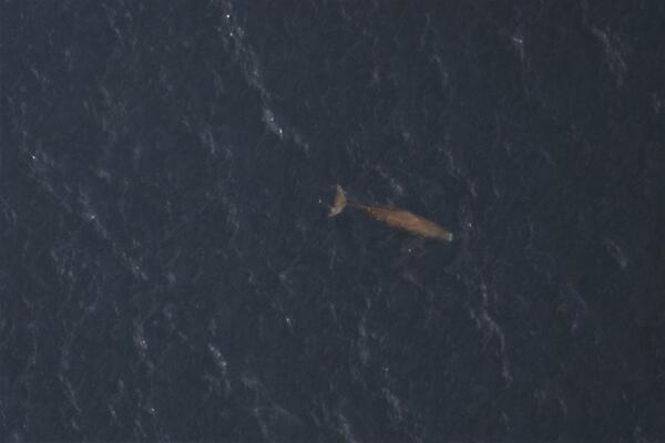
Zoomed image of a Sperm Whale (Physeter macrocephalus)
Zoomed image of a Sperm Whale (Physeter macrocephalus) below the surface, with contrast increased for clarity.
Zoomed image of a Sperm Whale (Physeter macrocephalus) below the surface, with contrast increased for clarity.

Annotated photograph of the Halemaʻumaʻu eruption
Annotated eruption photograph taken at 5 p.m. HST on December 30, 2020, from the south rim of Halemaʻumaʻu, Kīlauea Volcano summit. USGS photo by K. Lynn.
Annotated eruption photograph taken at 5 p.m. HST on December 30, 2020, from the south rim of Halemaʻumaʻu, Kīlauea Volcano summit. USGS photo by K. Lynn.

Jon Cohl ADCP at 01457400 Musconetcong Riegelsville
Photo Contest Winner | January 2021 | People
Jon Cohl ADCP at 01457400 Musconetcong Riegelsville
Photo Contest Winner | January 2021 | People
Jon Cohl ADCP at 01457400 Musconetcong Riegelsville