Five ways climate change affects manatees.
Graphic created by VSFS intern, Louise Johansson

Official websites use .gov
A .gov website belongs to an official government organization in the United States.
Secure .gov websites use HTTPS
A lock () or https:// means you’ve safely connected to the .gov website. Share sensitive information only on official, secure websites.
See our science through the images below.

Five ways climate change affects manatees.
Graphic created by VSFS intern, Louise Johansson
Five ways climate change affects manatees.
Graphic created by VSFS intern, Louise Johansson

5 Ways Climate Change Affects Bats.
Graphic created by VSFS intern Louise Johansson.
5 Ways Climate Change Affects Bats.
Graphic created by VSFS intern Louise Johansson.

The words "5 Ways Climate Change Affects Bears" with an image of a bear.
Text reads:
"Drought can reduce the availability of important foods like berries & seeds”
"When less food is available, bears will sometimes turn to garbage bins, bird feeders, & other sources of food found near humans, leading to human-bear conflicts"

Hoary bat with a Motus tag. Learn more about our project to track bats and birds through the Motus network here: https://www.usgs.gov/centers/werc/science/birds-bats-and-beyond-network…
Hoary bat with a Motus tag. Learn more about our project to track bats and birds through the Motus network here: https://www.usgs.gov/centers/werc/science/birds-bats-and-beyond-network…

Gabe Reyes holds a hoary bat during the process of tagging bats with Motus tags.
Gabe Reyes holds a hoary bat during the process of tagging bats with Motus tags.

Pie chart showing distribution of USGS 2020CARES Act funding in millions of dollars. Exact amounts include \$5,181,638 for Tracking Bats and Coronaviruses (wildlife Biosurveillance); \$3,192,316 for COVID-19 Pathways and Wildlife Dynamics; \$1,373,704 for Environmental Biosurveillance and Persistence.
Pie chart showing distribution of USGS 2020CARES Act funding in millions of dollars. Exact amounts include \$5,181,638 for Tracking Bats and Coronaviruses (wildlife Biosurveillance); \$3,192,316 for COVID-19 Pathways and Wildlife Dynamics; \$1,373,704 for Environmental Biosurveillance and Persistence.

The rusty patched bumblebee is the first bee to be listed as endangered in the continental US, and the western bumblebee has been the subject of extensive USGS work that has found effects of climate, land cover change, and pesticides on the decline of the species.
The rusty patched bumblebee is the first bee to be listed as endangered in the continental US, and the western bumblebee has been the subject of extensive USGS work that has found effects of climate, land cover change, and pesticides on the decline of the species.

Location of Core Sagebrush Areas, Growth Opportunity Areas, and Other Rangeland Areas identified within the sagebrush biome of the United States of America, By: Doherty et al., 2022 from publication “A Sagebrush Conservation Design to Proactively Restore America’s Sagebrush Biome.” .
Location of Core Sagebrush Areas, Growth Opportunity Areas, and Other Rangeland Areas identified within the sagebrush biome of the United States of America, By: Doherty et al., 2022 from publication “A Sagebrush Conservation Design to Proactively Restore America’s Sagebrush Biome.” .

Eric White and Patrick Scordato of the USGS float an electromagnetic imaging tool along a coastal area in Massachusetts to identify terrestrial groundwater discharge that may be impacted by PFAS contamination.
Eric White and Patrick Scordato of the USGS float an electromagnetic imaging tool along a coastal area in Massachusetts to identify terrestrial groundwater discharge that may be impacted by PFAS contamination.

Image shows different types of sample containers filled with a variety of sample matrices tested by the OGRL.
Image shows different types of sample containers filled with a variety of sample matrices tested by the OGRL.
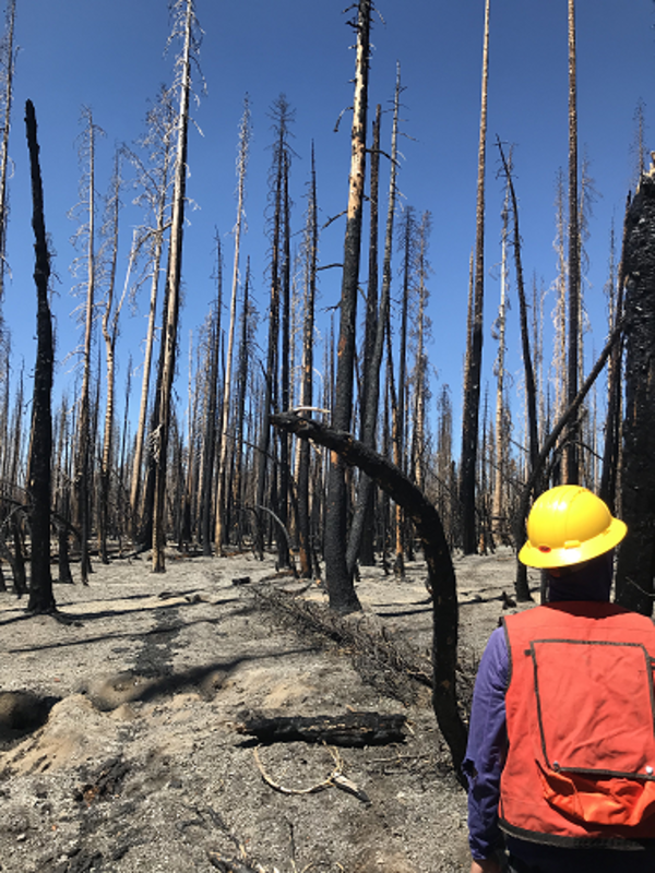
USGS crew measuring forest conditions following the Dixie Fire in 2021. Lassen Volcanic National Park. California.
USGS crew measuring forest conditions following the Dixie Fire in 2021. Lassen Volcanic National Park. California.

Five ways climate change affects reptiles.
Graphic created by VSFS intern, Louise Johansson.
Five ways climate change affects reptiles.
Graphic created by VSFS intern, Louise Johansson.

A honey bee (Apis mellifera) is spotted on a sunflower. National Honey Bee Day is observed on the third Saturday in August.
A honey bee (Apis mellifera) is spotted on a sunflower. National Honey Bee Day is observed on the third Saturday in August.

Image that shows the research framework for the Environmental Health Program's Source to Receptor Research for Environmental Contaminants
Image that shows the research framework for the Environmental Health Program's Source to Receptor Research for Environmental Contaminants

Setting up fuel transects within an archaeological site at Sequoia National Park to understand potential future fire behavior and how it could affect artifacts within the site. Pictured: Grant Snitker (foreground) and Alex Fetteroff (background), New Mexico Consortium. Copyright: Photo by Grant Snitker, New Mexico Consortium.
Setting up fuel transects within an archaeological site at Sequoia National Park to understand potential future fire behavior and how it could affect artifacts within the site. Pictured: Grant Snitker (foreground) and Alex Fetteroff (background), New Mexico Consortium. Copyright: Photo by Grant Snitker, New Mexico Consortium.

Using terrestrial LiDAR to characterize fuels within an archaeological site at Sequoia National Park site to understand potential future fire behavior and its effects on artifacts. Copyright: Photo by Grant Snitker, New Mexico Consortium.
Using terrestrial LiDAR to characterize fuels within an archaeological site at Sequoia National Park site to understand potential future fire behavior and its effects on artifacts. Copyright: Photo by Grant Snitker, New Mexico Consortium.

A precontact rockshelter and associated artifacts impacted by the combustion of heavy fuels during the KNP Complex Fire, California. Copyright: photo by Grant Snitker, New Mexico Consortium.
A precontact rockshelter and associated artifacts impacted by the combustion of heavy fuels during the KNP Complex Fire, California. Copyright: photo by Grant Snitker, New Mexico Consortium.

Historic cans from a refuse pile that were scorched by the combustion of nearby fuels during the Caldor Fire, California. Copyright: photo taken by Grant Snitker, New Mexico Consortium.
Historic cans from a refuse pile that were scorched by the combustion of nearby fuels during the Caldor Fire, California. Copyright: photo taken by Grant Snitker, New Mexico Consortium.

Elaine Nakash educates visitors and volunteers alike at the USGS Bird Banding Laboratory's display table, which was setup for the Latino Conservation Week event at the National Wildlife Visitor Center at Patuxent Research Refuge.
Elaine Nakash educates visitors and volunteers alike at the USGS Bird Banding Laboratory's display table, which was setup for the Latino Conservation Week event at the National Wildlife Visitor Center at Patuxent Research Refuge.

Image of a western meadowlark, a grassland-dwelling bird species. Credit: USFWS, public domain
Image of a western meadowlark, a grassland-dwelling bird species. Credit: USFWS, public domain

This passive acoustic recording device has been deployed in Montana (MT) as part of the North American Bat Monitoring Programs (NABat) summertime survey efforts. It has an ultrasonic microphone placed at the top of a 10ft pole that records echolocating bats fro
This passive acoustic recording device has been deployed in Montana (MT) as part of the North American Bat Monitoring Programs (NABat) summertime survey efforts. It has an ultrasonic microphone placed at the top of a 10ft pole that records echolocating bats fro