
Map of maximum uranium concentration at 206 spring and well sites in the Grand Canyon region.
Images
See our science through the images below.
Filter Total Items: 3148
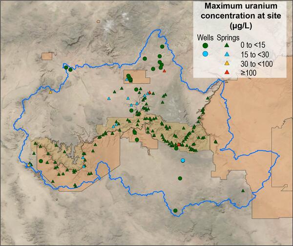
Map of Grand Canyon uranium concentrations as spring and well sites
Map of maximum uranium concentration at 206 spring and well sites in the Grand Canyon region.

Triple-high mist net in front of Half Dome
Triple-high mist net in front of Half Dome. The net is used to capture bats as part of a study tracking bat movements in Yosemite National Park.
Triple-high mist net in front of Half Dome. The net is used to capture bats as part of a study tracking bat movements in Yosemite National Park.

California myotis with transmitter
A California myotis with a transmitter, part of a study of bats in Yosemite National Park.
A California myotis with a transmitter, part of a study of bats in Yosemite National Park.

Reducing Uncertainties in Eastern Black Rail Conservation
Reducing uncertainties in Eastern black rail conservation. Qualitative value of information to identify field experiments in a resilience-experimentalist adaptive management framework.
Reducing uncertainties in Eastern black rail conservation. Qualitative value of information to identify field experiments in a resilience-experimentalist adaptive management framework.

Graduate students enter fishery data at Apache Lake in Arizona
Graduate students at the Arizona Cooperative Fish and Wildlife Research Unit calibrate gear and test new fish sampling techniques (hydroacoustics, electrofishing boat operation) in Western canyon-bound reservoirs in Arizona. The research compares Arizona Game and Fish Department (AZGFD) sampling protocols with American Fisheries Society (AFS) standar
Graduate students at the Arizona Cooperative Fish and Wildlife Research Unit calibrate gear and test new fish sampling techniques (hydroacoustics, electrofishing boat operation) in Western canyon-bound reservoirs in Arizona. The research compares Arizona Game and Fish Department (AZGFD) sampling protocols with American Fisheries Society (AFS) standar

Phoenix Aguilar McFarlane is a sophomore at the University of Idaho
Phoenix Aguilar McFarlane is a sophomore majoring in Environmental Science at the University of Idaho College of Natural Resources at the USGS Idaho Cooperative Fish and Wildlife Research Program. She came to the Doris Duke Conservation Scholars Program (DDCSP) with a can-do attitude and a passion for volunteering in community service and sustainability projects.
Phoenix Aguilar McFarlane is a sophomore majoring in Environmental Science at the University of Idaho College of Natural Resources at the USGS Idaho Cooperative Fish and Wildlife Research Program. She came to the Doris Duke Conservation Scholars Program (DDCSP) with a can-do attitude and a passion for volunteering in community service and sustainability projects.

Restoration at Tsegi Canyon
Restoration project at Tsegi Canyon in support of cultural and ecological resources. It was a community project that brought together agency professionals, elders and native youth. This was a partnership with Navajo Nation and USGS Restoration Assessment and Monitoring Program for the Southwest.
Restoration project at Tsegi Canyon in support of cultural and ecological resources. It was a community project that brought together agency professionals, elders and native youth. This was a partnership with Navajo Nation and USGS Restoration Assessment and Monitoring Program for the Southwest.
Tsegi_Logo.jpg
The Restoration Assessment and Monitoring Program for the Southwest (RAMPS) is working with the Navajo Nation Department of Natural Heritage to build capacity for ecosystem restoration in response to climate change and drought.
The Restoration Assessment and Monitoring Program for the Southwest (RAMPS) is working with the Navajo Nation Department of Natural Heritage to build capacity for ecosystem restoration in response to climate change and drought.

Economist coloring page
Natural Resource Economist coloring page.
By

Applying hot water to control invasive corallimorphs at Palmyra Atoll National Wildlife Refuge
USGS scientists and partners applied hot water as a control method for invasive corallimorphs at Palmyra Atoll National Wildlife Refuge.
USGS scientists and partners applied hot water as a control method for invasive corallimorphs at Palmyra Atoll National Wildlife Refuge.

Applying toxic paste to control invasive corallimorphs at Palmyra Atoll National Wildlife Refuge
linkUSGS scientists and partners applied a toothpaste-like compound mixed with sodium hydroxide as a control method for invasive corallimorphs at Palmyra Atoll National Wildlife Refuge.
Applying toxic paste to control invasive corallimorphs at Palmyra Atoll National Wildlife Refuge
linkUSGS scientists and partners applied a toothpaste-like compound mixed with sodium hydroxide as a control method for invasive corallimorphs at Palmyra Atoll National Wildlife Refuge.

Ruby Lake National Wildlife Reserve
Ruby Lake National Wildlife Refuge lies at the southern end of Ruby Valley in northeast Nevada. For more information visit the Ruby Lake NWR website.
By
Ecosystems Mission Area, Water Resources Mission Area, Land Management Research Program, Water Availability and Use Science Program, Climate Adaptation Science Centers, Forest and Rangeland Ecosystem Science Center, Fort Collins Science Center, Nevada Water Science Center, Oregon Water Science Center, Utah Water Science Center, Western Ecological Research Center (WERC), Saline Lakes Ecosystems Integrated Water Availability Assessment

Satellite reflectance for Milford Lake near Wakefield, Kansas

Barred owl movement west
Barred owls spread west during the 1900s and today completely overlap the range of the northern spotted owl.
Barred owls spread west during the 1900s and today completely overlap the range of the northern spotted owl.

Barred owl sightings at Oregon Coast Range monitoring sites, 2015
Locations of barred owl sightings recorded during 2015 owl monitoring activities. Barred owls were lethally removed from the areas highlighted in pink. Supporting data is found at https://doi.org/10.3133/ofr20201089.
Locations of barred owl sightings recorded during 2015 owl monitoring activities. Barred owls were lethally removed from the areas highlighted in pink. Supporting data is found at https://doi.org/10.3133/ofr20201089.

Barred owl sightings at Oregon Coast Range monitoring sites, 2020
Locations of barred owl sightings recorded during 2020 owl monitoring activities. Barred owls were lethally removed from the areas highlighted in pink. Supporting data is found at https://doi.org/10.3133/ofr20201089.
Locations of barred owl sightings recorded during 2020 owl monitoring activities. Barred owls were lethally removed from the areas highlighted in pink. Supporting data is found at https://doi.org/10.3133/ofr20201089.

Field Crew in the Adirondacks of New York Estimate Moose Density
Field crew in the Adirondacks of New York using detection dogs to find moose scats for a capture-recapture study to estimate moose density.
Field crew in the Adirondacks of New York using detection dogs to find moose scats for a capture-recapture study to estimate moose density.

Idaho Graduate Student on a boat studying steelhead
In cooperation with the Idaho Department of Fish and Game (IDFG) the Idaho Unit recently completed a series of research projects to better understand the effects of catch-and-release angling on survival and reproductive success of native trout and steelhead.
In cooperation with the Idaho Department of Fish and Game (IDFG) the Idaho Unit recently completed a series of research projects to better understand the effects of catch-and-release angling on survival and reproductive success of native trout and steelhead.

Tule white-fronted geese flying over Summer Lake Wildlife Area
Five tule white-fronted geese flying over Summer Lake Wildlife Area, the primary stopover site for this species on its fall migration.
Five tule white-fronted geese flying over Summer Lake Wildlife Area, the primary stopover site for this species on its fall migration.

Tule white-fronted geese flying over Summer Lake Wildlife Area, OR
Six tule white-fronted geese flying over Summer Lake Wildlife Area, the primary stopover site for this species on its fall migration.
Six tule white-fronted geese flying over Summer Lake Wildlife Area, the primary stopover site for this species on its fall migration.

Tule white-fronted geese landing in Summer Lake Wildlife Area
Tule white-fronted geese get ready to land at Summer Lake Wildlife Area in Oregon. The geese turn upside down and sideways to drop altitude quickly to land, a behavior known as "whiffling" or "maple leafing."
Tule white-fronted geese get ready to land at Summer Lake Wildlife Area in Oregon. The geese turn upside down and sideways to drop altitude quickly to land, a behavior known as "whiffling" or "maple leafing."