
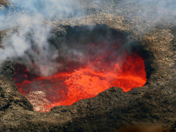
A telephoto view of the west vent along the western wall of Halema‘uma‘u crater at the summit of Kīlauea. On November 9, spatter bursts in the west vent cone triggered sloshing on the surface of the ponded lava. Spatter was thrown about 6–9 m (20–30 ft) above the pond surface and occasionally deposited onto the rim of the cone.
Images
Images intro.
Filter Total Items: 7145
Lava sloshing and spattering in west vent in Halema‘uma‘u
A telephoto view of the west vent along the western wall of Halema‘uma‘u crater at the summit of Kīlauea. On November 9, spatter bursts in the west vent cone triggered sloshing on the surface of the ponded lava. Spatter was thrown about 6–9 m (20–30 ft) above the pond surface and occasionally deposited onto the rim of the cone.

HyPrCal Laboratory tools
The USGS Gas Hydrates Project develops and tests new tools to address the critical knowledge gaps identified as scientists analyze hydrate-bearing pressure cores recovered during field programs. HyPrCal Laboratory analysis using Pressure Core Characterization Tools.
The USGS Gas Hydrates Project develops and tests new tools to address the critical knowledge gaps identified as scientists analyze hydrate-bearing pressure cores recovered during field programs. HyPrCal Laboratory analysis using Pressure Core Characterization Tools.
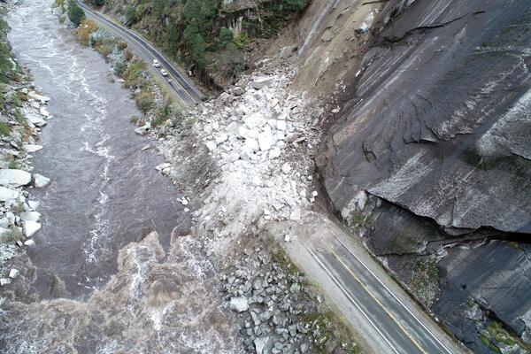
Rockslide on California State Route 70 in the Feather River Canyon, Butte/Plumas county line, northern California
linkRockslide on California State Route 70 in the Feather River Canyon, Butte/Plumas county line, northern California. This slide was triggered on October 24, 2021 by a Category 5 atmospheric river, which released more than ten inches of rain in the area over a 48-hour period. Approximately seven thousand cubic yards of rock and debris buried and closed the highway.

Chambers Landslide Monitoring Site, 2021 Dixie Fire, near Belden, California
The USGS “Chambers” site is located in the Plumas National Forest in northern California. The site consists of instrumentation monitoring the hillslope in the lower part of the image. The hillslope exhibits moderate soil burn severity and hosts sandy soils derived from granitic bedrock.
The USGS “Chambers” site is located in the Plumas National Forest in northern California. The site consists of instrumentation monitoring the hillslope in the lower part of the image. The hillslope exhibits moderate soil burn severity and hosts sandy soils derived from granitic bedrock.

Chips Landslide Monitoring Site, 2021 Dixie Fire, near Belden, California
The USGS “Chips” site is located in the Plumas National Forest in northern California. The site consists of instrumentation monitoring the hillslope in the lower part of the image. The hillslope exhibits moderate soil burn severity and hosts silty soils derived from metamorphic bedrock.
The USGS “Chips” site is located in the Plumas National Forest in northern California. The site consists of instrumentation monitoring the hillslope in the lower part of the image. The hillslope exhibits moderate soil burn severity and hosts silty soils derived from metamorphic bedrock.

Kīlauea summit eruption - September 30, 2021
Aerial image of eruption in Halemaʻumaʻu at Kīlauea Volcano's summit taken during an overflight at approximately 7:30 a.m. HST on September 30, 2021. The eruption is generating a vigorous plume of volcanic gas, including sulfur dioxide, being transported downwind.
Aerial image of eruption in Halemaʻumaʻu at Kīlauea Volcano's summit taken during an overflight at approximately 7:30 a.m. HST on September 30, 2021. The eruption is generating a vigorous plume of volcanic gas, including sulfur dioxide, being transported downwind.

Kīlauea summit eruption - September 30, 2021
Aerial image of eruption in Halemaʻumaʻu at Kīlauea Volcano's summit taken during an overflight at approximately 7:30 a.m. HST on September 30, 2021. In this image, multiple active fountaining sources are visible in the central and western portions of Halemaʻumaʻu.
Aerial image of eruption in Halemaʻumaʻu at Kīlauea Volcano's summit taken during an overflight at approximately 7:30 a.m. HST on September 30, 2021. In this image, multiple active fountaining sources are visible in the central and western portions of Halemaʻumaʻu.

Kīlauea summit eruption - September 30, 2021
Aerial image of eruption in Halemaʻumaʻu at Kīlauea Volcano's summit taken during an overflight at approximately 7:30 a.m. HST on September 30, 2021. Lava continues to erupt from multiple vents along the floor and western wall of Halemaʻumaʻu crater. As of this afternoon all lava activity is confined within Halemaʻumaʻu Crater.
Aerial image of eruption in Halemaʻumaʻu at Kīlauea Volcano's summit taken during an overflight at approximately 7:30 a.m. HST on September 30, 2021. Lava continues to erupt from multiple vents along the floor and western wall of Halemaʻumaʻu crater. As of this afternoon all lava activity is confined within Halemaʻumaʻu Crater.

Kīlauea summit eruption - September 30, 2021
Aerial image of eruption in Halemaʻumaʻu at Kīlauea Volcano's summit taken during an overflight at approximately 7:30 a.m. HST on September 30, 2021. The nascent lava lake has been rising approximately one meter (yard) an hour since the eruption began.
Aerial image of eruption in Halemaʻumaʻu at Kīlauea Volcano's summit taken during an overflight at approximately 7:30 a.m. HST on September 30, 2021. The nascent lava lake has been rising approximately one meter (yard) an hour since the eruption began.

Kīlauea summit eruption - September 30, 2021
Telephoto aerial image of eruption in Halemaʻumaʻu at Kīlauea Volcano's summit taken during an overflight at approximately 7:30 a.m. HST on September 30, 2021. This photo shows several of the fountaining sources on the base of Halemaʻumaʻu, which are only a few meters (yards) high. USGS image by K. Mulliken.
Telephoto aerial image of eruption in Halemaʻumaʻu at Kīlauea Volcano's summit taken during an overflight at approximately 7:30 a.m. HST on September 30, 2021. This photo shows several of the fountaining sources on the base of Halemaʻumaʻu, which are only a few meters (yards) high. USGS image by K. Mulliken.

Kīlauea summit eruption - September 30, 2021
Telephoto aerial image of eruption in Halemaʻumaʻu at Kīlauea Volcano's summit taken during an overflight at approximately 7:30 a.m. HST on September 30, 2021. A series of fountains in the central portion of the lava lake are visible, as well as the prominent vent in the west wall of Halemaʻumaʻu.
Telephoto aerial image of eruption in Halemaʻumaʻu at Kīlauea Volcano's summit taken during an overflight at approximately 7:30 a.m. HST on September 30, 2021. A series of fountains in the central portion of the lava lake are visible, as well as the prominent vent in the west wall of Halemaʻumaʻu.

Kīlauea summit eruption - September 30, 2021
Telephoto aerial image of eruption in Halemaʻumaʻu at Kīlauea Volcano's summit taken during an overflight at approximately 7:30 a.m. HST on September 30, 2021. This photo shows two of the many spattering sources active in the base of Halemaʻumaʻu, feeding the growing lava lake. The south wall of Halemaʻumaʻu crater is visible in the upper left portion of the image.
Telephoto aerial image of eruption in Halemaʻumaʻu at Kīlauea Volcano's summit taken during an overflight at approximately 7:30 a.m. HST on September 30, 2021. This photo shows two of the many spattering sources active in the base of Halemaʻumaʻu, feeding the growing lava lake. The south wall of Halemaʻumaʻu crater is visible in the upper left portion of the image.

Kīlauea summit eruption - September 30, 2021
Telephoto aerial image of eruption in Halemaʻumaʻu at Kīlauea Volcano's summit taken during an overflight at approximately 7:30 a.m. HST on September 30, 2021. This photo shows the eastern portoin of the nascent lava lake, where it meets the wall of Halemaʻumaʻu crater.
Telephoto aerial image of eruption in Halemaʻumaʻu at Kīlauea Volcano's summit taken during an overflight at approximately 7:30 a.m. HST on September 30, 2021. This photo shows the eastern portoin of the nascent lava lake, where it meets the wall of Halemaʻumaʻu crater.

Kīlauea summit eruption - September 30, 2021
Oblique telephoto aerial image of eruption in Halemaʻumaʻu at Kīlauea Volcano's summit taken during an overflight at approximately 7:30 a.m. HST on September 30, 2021.
Oblique telephoto aerial image of eruption in Halemaʻumaʻu at Kīlauea Volcano's summit taken during an overflight at approximately 7:30 a.m. HST on September 30, 2021.

Kīlauea summit eruption - September 30, 2021
Oblique aerial image of eruption in Halemaʻumaʻu at Kīlauea Volcano's summit taken during an overflight at approximately 7:30 a.m. HST on September 30, 2021. This view shows multiple active spattering sources in southern central part of Halemaʻumaʻu, and associated plumes of volcanic gas.
Oblique aerial image of eruption in Halemaʻumaʻu at Kīlauea Volcano's summit taken during an overflight at approximately 7:30 a.m. HST on September 30, 2021. This view shows multiple active spattering sources in southern central part of Halemaʻumaʻu, and associated plumes of volcanic gas.

Kīlauea summit eruption - September 30, 2021
Telephoto aerial image of eruption in Halemaʻumaʻu at Kīlauea Volcano's summit taken during an overflight at approximately 7:30 a.m. HST on September 30, 2021. The active vent in the west wall of Halemaʻumaʻu is vigorously fountaining, and is one of many fountaining sources active in the lava lake right now.
Telephoto aerial image of eruption in Halemaʻumaʻu at Kīlauea Volcano's summit taken during an overflight at approximately 7:30 a.m. HST on September 30, 2021. The active vent in the west wall of Halemaʻumaʻu is vigorously fountaining, and is one of many fountaining sources active in the lava lake right now.

Video camera snapshot at Pea Island National Wildlife Refuge
Two video cameras are temporarily mounted on a dune at Pea Island National Wildlife Refuge on the Outer Banks of North Carolina. The cameras are imaging the southern DUNEX experiment site and are designed to have a stereo view of the beach and potential overwash path until late October. Instruments from the U.S.
Two video cameras are temporarily mounted on a dune at Pea Island National Wildlife Refuge on the Outer Banks of North Carolina. The cameras are imaging the southern DUNEX experiment site and are designed to have a stereo view of the beach and potential overwash path until late October. Instruments from the U.S.

Installing Coastal Camera Tower
Time-lapse of USGS researchers raising a mechanical mast with a high-resolution camera mounted on top, which was deployed atop a dune in the U.S.
Time-lapse of USGS researchers raising a mechanical mast with a high-resolution camera mounted on top, which was deployed atop a dune in the U.S.

Looking out at the Pea Island Experiment Cross-shore array
Researchers from the USGS and North Carolina Universites set up their equipment on installed poles stretching from the dune to the surf zone.
Researchers from the USGS and North Carolina Universites set up their equipment on installed poles stretching from the dune to the surf zone.

IMG_0302.jpeg
Image showing a section of Lava River Cave, located in Northern Arizona.
Image showing a section of Lava River Cave, located in Northern Arizona.

USGS personnel and contracted divers work together to install instrume
To install instruments offshore professional divers were hired to work alongside USGS personnel. Here, long segments of pipe are jetted into the seafloor to which instruments will be attached to measure offshore oceanographic conditions.
To install instruments offshore professional divers were hired to work alongside USGS personnel. Here, long segments of pipe are jetted into the seafloor to which instruments will be attached to measure offshore oceanographic conditions.