
An alternative to uncrewed aerial systems (UAS; commonly known as 'drones'), U.S. Geological Survey (USGS) scientists use helikites equipped with cameras to collect imagery of the coastline. The pictures collected by these helium-powered kite-balloons are used to create a 3D digital elevation map of the beach.
Images
Images intro.
Filter Total Items: 7165

A helikite used to collect imagery of the coastline
An alternative to uncrewed aerial systems (UAS; commonly known as 'drones'), U.S. Geological Survey (USGS) scientists use helikites equipped with cameras to collect imagery of the coastline. The pictures collected by these helium-powered kite-balloons are used to create a 3D digital elevation map of the beach.

USGS-Black Swift Team Alaska
USGS-Black Swift Team with Super Swift UAS, Dutch Harbor Airport, Aleutian Islands, Alaska. Left-to-right: Dale Ruckman, Jack Elston, Christoph Kern, Angie Diefenbach, Maciej Stachura, Matt Burgess, Andy Dietrick.
USGS-Black Swift Team with Super Swift UAS, Dutch Harbor Airport, Aleutian Islands, Alaska. Left-to-right: Dale Ruckman, Jack Elston, Christoph Kern, Angie Diefenbach, Maciej Stachura, Matt Burgess, Andy Dietrick.

Preparing to launch the Automnous Surf Vehicle
To survey the bathymetry off of the Pea Island DUNEX site WHOI investigator Peter Traykovski prepares to run into the surf with the ASV nicknamed "Robo Turtle" while USGS investigator Chris Sherwood handles the remote controller.
To survey the bathymetry off of the Pea Island DUNEX site WHOI investigator Peter Traykovski prepares to run into the surf with the ASV nicknamed "Robo Turtle" while USGS investigator Chris Sherwood handles the remote controller.

Data collection at Duck USACE Field Research Station
The US Army Corps of Engineers Field Research Facility in Duck, NC has set up a variety of sensors and arrays on the beach to measure oceanographic paramters for DUNEX
The US Army Corps of Engineers Field Research Facility in Duck, NC has set up a variety of sensors and arrays on the beach to measure oceanographic paramters for DUNEX

Surveying with the Helikite at Pea Island, NC
The Helikite in action, being walked by WHOI scientist, Peter Traykovski, at Pea Island DUNEX site, the helium powered balloon kite is used to survey the beach and dune to produce elevation models using Structure from Motion.
The Helikite in action, being walked by WHOI scientist, Peter Traykovski, at Pea Island DUNEX site, the helium powered balloon kite is used to survey the beach and dune to produce elevation models using Structure from Motion.

DUNEX Crew
A calm hazy horizon after the team pushed two boats up and over the dune to be launched from the beach on Pea Island.
This field work was conducted as part of the During Nearshore Event Experiment (DUNEX) in 2021.
A calm hazy horizon after the team pushed two boats up and over the dune to be launched from the beach on Pea Island.
This field work was conducted as part of the During Nearshore Event Experiment (DUNEX) in 2021.

DUNEX Cross-Shore Array
Cross-shore array of poles equipped with various sensors to measure water level and other parameters at Pea Island National Wildlife Refuge. This equipment was deployed as part of the During Nearshore Event Experiment (DUNEX) in 2021.
Cross-shore array of poles equipped with various sensors to measure water level and other parameters at Pea Island National Wildlife Refuge. This equipment was deployed as part of the During Nearshore Event Experiment (DUNEX) in 2021.

Planning the ASV Route bathymetry
To survey the bathymetry off of the Pea Island DUNEX site WHOI investigator Peter Traykovski, and USGS investigator, Chris Sherwood, prepare to launch the ASV into the water to measure the bathymetry of the Pea Island DUNEX site.
To survey the bathymetry off of the Pea Island DUNEX site WHOI investigator Peter Traykovski, and USGS investigator, Chris Sherwood, prepare to launch the ASV into the water to measure the bathymetry of the Pea Island DUNEX site.

Installing CoastCam at Pea Island before a storm
Assembling the CoastCam station, USGS researchers Jenna Brown and Meg Palmsten stake down support wires as a storm approaches the Pea Island field site.
This field work was conducted as part of the During Nearshore Event Experiment (DUNEX) in 2021.
Assembling the CoastCam station, USGS researchers Jenna Brown and Meg Palmsten stake down support wires as a storm approaches the Pea Island field site.
This field work was conducted as part of the During Nearshore Event Experiment (DUNEX) in 2021.

Video camera setup at Point Barrow, Alaska
Point Barrow, Alaska, or Nuvuk, is the northernmost point in the United States. USGS has set up video cameras, mounted to the pole shown here, to study sediment movement and wave dynamics along this dynamic coastline.
Point Barrow, Alaska, or Nuvuk, is the northernmost point in the United States. USGS has set up video cameras, mounted to the pole shown here, to study sediment movement and wave dynamics along this dynamic coastline.

Video camera setup at Nuvuk, Alaska
Point Barrow, Alaska, or Nuvuk, is the northernmost point in the United States. USGS has set up video cameras, mounted to the pole shown here, to study sediment movement and wave dynamics along this dynamic coastline.
Point Barrow, Alaska, or Nuvuk, is the northernmost point in the United States. USGS has set up video cameras, mounted to the pole shown here, to study sediment movement and wave dynamics along this dynamic coastline.

Video camera setup, Point Barrow, Alaska
Point Barrow, Alaska, or Nuvuk, is the northernmost point in the United States. USGS has set up video cameras, mounted to the pole shown here, to study sediment movement and wave dynamics along this dynamic coastline.
Point Barrow, Alaska, or Nuvuk, is the northernmost point in the United States. USGS has set up video cameras, mounted to the pole shown here, to study sediment movement and wave dynamics along this dynamic coastline.

Elkhorn Coral in Tres Palmas Marine Reserve, Rincón, Puerto Rico
Elkhorn coral (Acropora palmata) in Tres Palmas Marine Reserve, Rincón, Puerto Rico. This coral can form reef crests and cause waves to break, providing significant protection to the coast.
Elkhorn coral (Acropora palmata) in Tres Palmas Marine Reserve, Rincón, Puerto Rico. This coral can form reef crests and cause waves to break, providing significant protection to the coast.
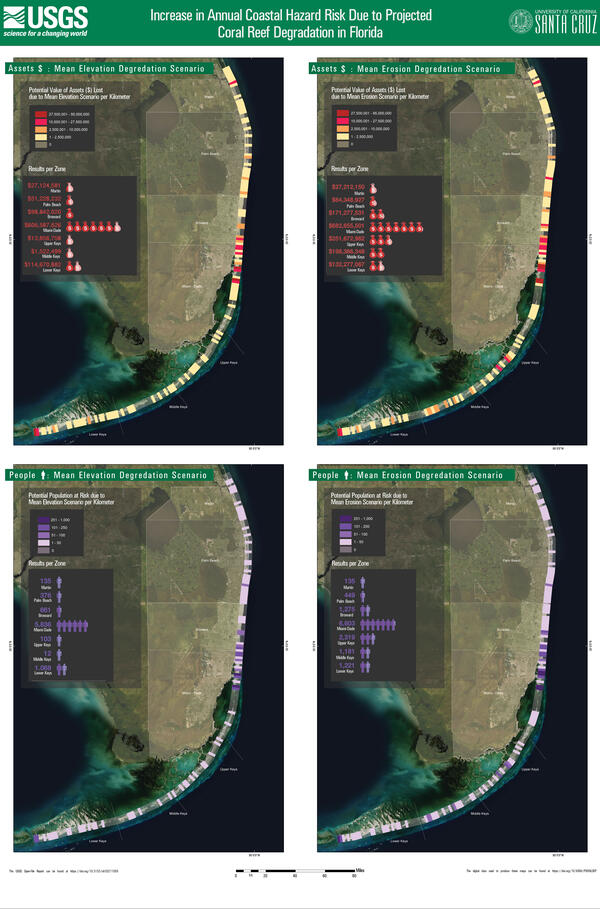
Coastal hazard risk increase due to reef degradation: Florida
Four scenarios for the southern part of the Florida coastline show the increase in annual coastal hazard risk due to projected coral reef degradation.
Four scenarios for the southern part of the Florida coastline show the increase in annual coastal hazard risk due to projected coral reef degradation.

Annual coastal hazard risk increase due to hurricanes in Florida
Maps for the southern part of the Florida coastline show the increase in annual coastal hazard risk due to damage by Hurricanes Irma and Maria.
- Increase in population at risk due to coral reef damage per kilometer (left)
- Increase in value ($) of assets at risk due to coral reef damage per kilometer (right)

Potential annual coastal hazard risk decrease: Florida
Maps show the potential decrease in annual coastal hazard risk provided by coral reef restoration in Florida.
Maps show the potential decrease in annual coastal hazard risk provided by coral reef restoration in Florida.

Impact of damage by hurricanes Irma and Maria in Puerto Rico
Maps of Puerto Rico show the increase in annual coastal hazard risk due to damage by Hurricanes Irma and Maria.
- Increase in population at risk due to coral reef damage per kilometer (top)
- Increase in value ($) of assets at risk due to coral reef damage per kilometer (bottom)
Maps of Puerto Rico show the increase in annual coastal hazard risk due to damage by Hurricanes Irma and Maria.
- Increase in population at risk due to coral reef damage per kilometer (top)
- Increase in value ($) of assets at risk due to coral reef damage per kilometer (bottom)
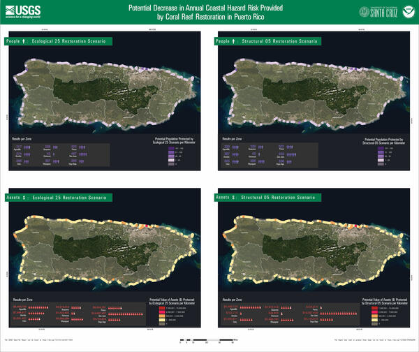
Potential annual coastal hazard risk decrease: Puerto Rico
Maps show the potential decrease in annual coastal hazard risk provided by coral reef restoration in Puerto Rico.
Maps show the potential decrease in annual coastal hazard risk provided by coral reef restoration in Puerto Rico.

Social and economic benefits of coral reef restoration: Puerto Rico 1
Report Summary
The Social and Economic Benefits of Coral Reef Restoration in Puerto Rico
Key Points
Report Summary
The Social and Economic Benefits of Coral Reef Restoration in Puerto Rico
Key Points

Social and economic benefits of coral reef restoration: Puerto Rico 2
Coral reef restoration can yield significant flood reduction benefits. These natural defenses were damaged in the 2017 hurricanes; their recovery would reduce the risks of further storm damages to nature, people and property.
Coral reef restoration can yield significant flood reduction benefits. These natural defenses were damaged in the 2017 hurricanes; their recovery would reduce the risks of further storm damages to nature, people and property.

Beneficios sociales y económicos de la restauración: Puerto Rico 1
RESUMEN DEL REPORTE
Los beneficios sociales y económicos de la restauración de arrecifes de coral en Puerto Rico
PUNTOS CLAVE
RESUMEN DEL REPORTE
Los beneficios sociales y económicos de la restauración de arrecifes de coral en Puerto Rico
PUNTOS CLAVE