
Sunrise with a recently deployed buoy measuring meteorological data off Fire Island, NY in 2012. The data collected is part of a study of the coastal processes that mobilize and transport sediment in the region
Images
Images intro.
Filter Total Items: 7147

Fire Island, NY sunrise
Sunrise with a recently deployed buoy measuring meteorological data off Fire Island, NY in 2012. The data collected is part of a study of the coastal processes that mobilize and transport sediment in the region

Anti-fouling treatment is applied to a sensor on a platform
Anti-fouling treatment is applied to a sensor on a platform about to be deployed off Fire Island, NY in 2012. The data collected is part of a study of the coastal processes that mobilize and transport sediment in the region
Anti-fouling treatment is applied to a sensor on a platform about to be deployed off Fire Island, NY in 2012. The data collected is part of a study of the coastal processes that mobilize and transport sediment in the region

Volunteers Ben Gaddis and Andrew Hara holding a photo of Thomas Jag...
The image shows a gas collection system from the wells at Sulphur Banks. Jaggar made the following note in his daily log: "September, 1940. Dr. S.S. Ballard of the University of Hawaii physics department intiated an improved method of dry gas collection at Sulphur Banks.
The image shows a gas collection system from the wells at Sulphur Banks. Jaggar made the following note in his daily log: "September, 1940. Dr. S.S. Ballard of the University of Hawaii physics department intiated an improved method of dry gas collection at Sulphur Banks.

Seismologist Jerry Eaton gives Observatory a technology boost in 1950s
The late Jerry P. Eaton came to the Hawaiian Volcano Observatory in 1953 and served as HVO's Scientist-in-Charge in 1956-1958 and again in 1960-61.
The late Jerry P. Eaton came to the Hawaiian Volcano Observatory in 1953 and served as HVO's Scientist-in-Charge in 1956-1958 and again in 1960-61.

Spattering in Pu‘u ‘Ō‘ō and Episode 61 flow field
A burst of gas from a small vent in Pu‘u ‘Ō‘ō crater throws spatter about 15 m (50 ft) into the air. Over the past week, occasional spattering and short lava flows have been observed within the crater.
A burst of gas from a small vent in Pu‘u ‘Ō‘ō crater throws spatter about 15 m (50 ft) into the air. Over the past week, occasional spattering and short lava flows have been observed within the crater.

outcrop of eroded, dissected extinct volcano, Frio River
Photograph showing outcrop of eroded and dissected extinct volcano located adjacent to the Frio River and east of the city of Uvalde in Uvalde County, Texas. Basalt is remnant of volcanic neck, and adjacent to the basalt is pyroclastic material ranging from fine-grained material to volcanic bombs, which formed the slope of the volcano.
Photograph showing outcrop of eroded and dissected extinct volcano located adjacent to the Frio River and east of the city of Uvalde in Uvalde County, Texas. Basalt is remnant of volcanic neck, and adjacent to the basalt is pyroclastic material ranging from fine-grained material to volcanic bombs, which formed the slope of the volcano.

Episode 61 (Peace Day) flow: Jan 12, 2013
Map showing lava flows erupted during Kīlauea's ongoing east rift zone eruption and labeled with the years in which they were active.
Map showing lava flows erupted during Kīlauea's ongoing east rift zone eruption and labeled with the years in which they were active.

Spattering in Pu‘u ‘Ō‘ō and Episode 61 flow field
A burst of gas from a small vent in Pu‘u ‘Ō‘ō crater throws spatter about 15 m (50 ft) into the air. Over the past week, occasional spattering and short lava flows have been observed within the crater.
A burst of gas from a small vent in Pu‘u ‘Ō‘ō crater throws spatter about 15 m (50 ft) into the air. Over the past week, occasional spattering and short lava flows have been observed within the crater.

A single area of breakouts, visible as the silvery patch in the cen...
A single area of breakouts, visible as the silvery patch in the center of the photograph, was active on today's overflight. These surface flows are high above the pali, about 3.5 km (2.2 miles) southeast of Pu‘u ‘Ō‘ō cone. Pu‘u ‘Ō‘ō is visible in the upper left portion of the image.
A single area of breakouts, visible as the silvery patch in the center of the photograph, was active on today's overflight. These surface flows are high above the pali, about 3.5 km (2.2 miles) southeast of Pu‘u ‘Ō‘ō cone. Pu‘u ‘Ō‘ō is visible in the upper left portion of the image.

End of an Era at the HVO
Ever-smiling Maurice Sako during the mid-point of his career in the 1980s. Maurice retires this week after a 44-year career at the Hawaiian Volcano Observatory.
Ever-smiling Maurice Sako during the mid-point of his career in the 1980s. Maurice retires this week after a 44-year career at the Hawaiian Volcano Observatory.

Coral Reef Affected by White Syndrome
Coral reef affected by Montipora White Syndrome. Note the large swath of white skeleton tissue surrounded by normal (brown) corals.
Coral reef affected by Montipora White Syndrome. Note the large swath of white skeleton tissue surrounded by normal (brown) corals.

Thermal map of fissure system and lava flows
This thermal map shows the fissure system and lava flows as of 6 am on Thursday, July 12. The fountain at Fissure 8 remains active, with the lava flow entering the ocean at numerous points in Kapoho. The channel overflow from July 9-10 created a new lobe that reached the ocean over the past day, destroying Ahalanui Park and the nearby charter school.
This thermal map shows the fissure system and lava flows as of 6 am on Thursday, July 12. The fountain at Fissure 8 remains active, with the lava flow entering the ocean at numerous points in Kapoho. The channel overflow from July 9-10 created a new lobe that reached the ocean over the past day, destroying Ahalanui Park and the nearby charter school.

PCMSC Magnetometer
USGS Pacific Coastal and Marine Science Center field crew showing off the new magnetometer, named Magnetron, on fantail of Research Vessel (R/V) Parke Snavely.
USGS Pacific Coastal and Marine Science Center field crew showing off the new magnetometer, named Magnetron, on fantail of Research Vessel (R/V) Parke Snavely.

At Kīlauea, when the lava column drops below the water table, groun...
At Kīlauea, when the lava column drops below the water table, groundwater may come into contact with with magma or hot rocks, causing violent steam explosions.
At Kīlauea, when the lava column drops below the water table, groundwater may come into contact with with magma or hot rocks, causing violent steam explosions.
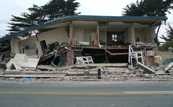
Earthquake-damaged building
Building damanged by the February 2011 earthquake in Christchurch, New Zealand.
Building damanged by the February 2011 earthquake in Christchurch, New Zealand.

Mount Rainier rises above Tacoma, WA and boat harbor, which may be ...
Mount Rainier rises above Tacoma, Washington and boat harbor, which may be impacted during the next eruption of the volcano.
Mount Rainier rises above Tacoma, Washington and boat harbor, which may be impacted during the next eruption of the volcano.

Backscatter intensity on Stellwagen Bank
Map C. Backscatter intensity and sun-illuminated topography. Blue= "soft" seabed, Green, orange = "hard" seabed
Map C. Backscatter intensity and sun-illuminated topography. Blue= "soft" seabed, Green, orange = "hard" seabed

Stellwagen Bank project research sites in the United States and Canada
Stellwagen Bank project research areas in the United States and Canada
Stellwagen Bank project research areas in the United States and Canada

San Diego Trough fault
Bird's-eye view map of a section of the seafloor off southern California, made with depth data. The map shows a channel wall that has been cut by the San Diego Trough fault and moved about 20 meters. This feature is about 1,000 meters below sea level.
Bird's-eye view map of a section of the seafloor off southern California, made with depth data. The map shows a channel wall that has been cut by the San Diego Trough fault and moved about 20 meters. This feature is about 1,000 meters below sea level.

Cape Hatteras, N.C.
Cape Hatteras, N.C.