
Map showing the extent of lava flows erupted during Kīlauea's ongoing east rift zone eruption and labeled with the years in which they were active.
Images
Images intro.
Filter Total Items: 7147

Kīlauea ERZ Eruption Map: Dec. 13, 2012
Map showing the extent of lava flows erupted during Kīlauea's ongoing east rift zone eruption and labeled with the years in which they were active.

Active pāhoehoe, fed by a lava tube originating at Pu‘u ‘Ō‘ō, has b...
This photograph, taken from the east rim of Pu‘u ‘Ō‘ō crater, shows a cone in the crater which was occasionally spitting minor amounts of spatter from the incandescent opening at its top.
This photograph, taken from the east rim of Pu‘u ‘Ō‘ō crater, shows a cone in the crater which was occasionally spitting minor amounts of spatter from the incandescent opening at its top.

Active pāhoehoe, fed by a lava tube originating at Pu‘u ‘Ō‘ō
Active pāhoehoe, fed by a lava tube originating at Pu‘u ‘Ō‘ō, has been migrating downslope within the Royal Gardens subdivision over the past week. The flow front is outlined by the white dotted line. The flow is running alongside a forested kipuka, triggering brush fires visible in the photo.
Active pāhoehoe, fed by a lava tube originating at Pu‘u ‘Ō‘ō, has been migrating downslope within the Royal Gardens subdivision over the past week. The flow front is outlined by the white dotted line. The flow is running alongside a forested kipuka, triggering brush fires visible in the photo.

Pu‘u ‘Ō‘ō and Episode 61 flow field: Dec. 2, 2012
Map showing Pu‘u ‘Ō‘ō and the extent of nearby lava flows. The currently active flow (episode 61) is shown as the two shades of red—pink is the extent of the flow from September 21 to November 21, and bright red marks flow expansion from November 21 to December 2. The contour interval on Pu‘u ‘Ō‘ō is 5 m.
Map showing Pu‘u ‘Ō‘ō and the extent of nearby lava flows. The currently active flow (episode 61) is shown as the two shades of red—pink is the extent of the flow from September 21 to November 21, and bright red marks flow expansion from November 21 to December 2. The contour interval on Pu‘u ‘Ō‘ō is 5 m.

Kīlauea ERZ Eruption Map: Dec. 2, 2012
Map showing the extent of lava flows erupted during Kīlauea's ongoing east rift zone eruption and labeled with the years in which they were active.
Map showing the extent of lava flows erupted during Kīlauea's ongoing east rift zone eruption and labeled with the years in which they were active.

Measuring Gravity in Earthquake Area
USGS geophysicist Steve Snyder is measuring gravity, for information on geology beneath the surface, and the GPS location of this measurement in the earthquake area.
USGS geophysicist Steve Snyder is measuring gravity, for information on geology beneath the surface, and the GPS location of this measurement in the earthquake area.

Studying Trench for Possible Earthquake-related Deformation
USGS geoscientists Wright Horton, Richard Harrison, and Anjana Shah (left to right) are studying an exploratory trench for possible earthquake-related deformation.
USGS geoscientists Wright Horton, Richard Harrison, and Anjana Shah (left to right) are studying an exploratory trench for possible earthquake-related deformation.

Vigorously spattering vent at the east end of Pu‘u ‘Ō‘ō
For a brief period this afternoon a vigorously spattering vent at the east end of Pu‘u ‘Ō‘ō crater fed a swiftly moving river of lava that cascaded into the deeper portions of the crater. The cascade was over within about ten minutes of this photograph, but the vent continued to spatter.
For a brief period this afternoon a vigorously spattering vent at the east end of Pu‘u ‘Ō‘ō crater fed a swiftly moving river of lava that cascaded into the deeper portions of the crater. The cascade was over within about ten minutes of this photograph, but the vent continued to spatter.

Pu‘u ‘Ō‘ō and Episode 61 flow field: Nov. 21, 2012
Map showing Pu‘u ‘Ō‘ō and the extent of nearby lava flows. The currently active flow (episode 61) is shown as the two shades of red—pink is the extent of the flow from September 21 to November 10, and bright red marks flow expansion from November 10 to November 21. The contour interval on Pu‘u ‘Ō‘ō is 5 m.
Map showing Pu‘u ‘Ō‘ō and the extent of nearby lava flows. The currently active flow (episode 61) is shown as the two shades of red—pink is the extent of the flow from September 21 to November 10, and bright red marks flow expansion from November 10 to November 21. The contour interval on Pu‘u ‘Ō‘ō is 5 m.

Kīlauea ERZ Eruption Map: Nov. 21, 2012
Map showing the extent of lava flows erupted during Kīlauea's ongoing east rift zone eruption and labeled with the years in which they were active.
Map showing the extent of lava flows erupted during Kīlauea's ongoing east rift zone eruption and labeled with the years in which they were active.

A thin portion of the roof over the lava tube reveals the lava stream
A collapse of a thin portion of the roof over the lava tube reveals the lava stream beneath the surface. The fluid stream is the bright orange color, with the dark orange area to the left representing the hot, incandescent tube wall. The lava stream today was relatively slow moving in the tube, perhaps reflecting a low rate of lava supply to the flow front.
A collapse of a thin portion of the roof over the lava tube reveals the lava stream beneath the surface. The fluid stream is the bright orange color, with the dark orange area to the left representing the hot, incandescent tube wall. The lava stream today was relatively slow moving in the tube, perhaps reflecting a low rate of lava supply to the flow front.

Pu‘u ‘Ō‘ō and Episode 61 flow field: Nov. 10, 2012
Map showing Pu‘u ‘Ō‘ō and the extent of nearby lava flows. The currently active flow (episode 61) is shown as the two shades of red—pink is the extent of the flow from September 21 to November 3, and bright red marks flow expansion from November 3 to November 10. The contour interval on Pu‘u ‘Ō‘ō is 5 m
Map showing Pu‘u ‘Ō‘ō and the extent of nearby lava flows. The currently active flow (episode 61) is shown as the two shades of red—pink is the extent of the flow from September 21 to November 3, and bright red marks flow expansion from November 3 to November 10. The contour interval on Pu‘u ‘Ō‘ō is 5 m

Kīlauea ERZ Eruption Map: Nov. 10, 2012
Map showing the extent of lava flows erupted during Kīlauea's ongoing east rift zone eruption and labeled with the years in which they were active.
Map showing the extent of lava flows erupted during Kīlauea's ongoing east rift zone eruption and labeled with the years in which they were active.

A large skylight on the lava tube is supplying lava to surface flow...
This photograph, looking east, shows a large skylight on the lava tube that is supplying lava to surface flows north of Royal Gardens subdivision. The tube trace, which heads southeast, is marked by the line of fume sources in the upper right portion of the image.
This photograph, looking east, shows a large skylight on the lava tube that is supplying lava to surface flows north of Royal Gardens subdivision. The tube trace, which heads southeast, is marked by the line of fume sources in the upper right portion of the image.

skylight
A close-up view of the skylight. The flowing lava stream in the tube was easily visible.
A close-up view of the skylight. The flowing lava stream in the tube was easily visible.
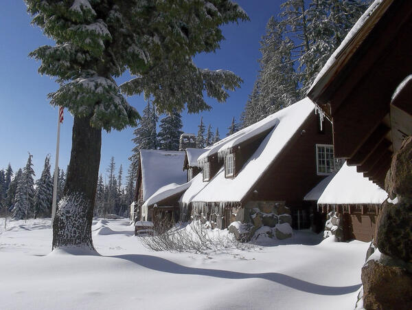
Steel Information Center in Winter at Crater Lake National Park.
Steel Information Center in Winter at Crater Lake National Park.
Steel Information Center in Winter at Crater Lake National Park.

Has Halema‘uma‘u's lava lake changed in 100 years?
Photo of the lava lake within the vent inset within the east wall and floor of Halema‘uma‘u Crater on March 3, 2011, just days before the Kamoamoa fissure eruption caused the lake level to drop much deeper and out of sight.
Photo of the lava lake within the vent inset within the east wall and floor of Halema‘uma‘u Crater on March 3, 2011, just days before the Kamoamoa fissure eruption caused the lake level to drop much deeper and out of sight.

Pu‘u ‘Ō‘ō and Episode 61 flow field: Nov. 3, 2012
Map showing Pu‘u ‘Ō‘ō and the extent of nearby lava flows. The flows of the currently active episode 61 east flank phase (September 21-ongoing) are the two shades of red—pink is the extent of the flow from September 21 to October 25, and bright red marks flow expansion from October 25 to November 3. The trace of the tube carrying lava downslope is shown in yellow.
Map showing Pu‘u ‘Ō‘ō and the extent of nearby lava flows. The flows of the currently active episode 61 east flank phase (September 21-ongoing) are the two shades of red—pink is the extent of the flow from September 21 to October 25, and bright red marks flow expansion from October 25 to November 3. The trace of the tube carrying lava downslope is shown in yellow.

Kīlauea ERZ Eruption Map: Nov. 3, 2012
Map showing the extent of lava flows erupted during Kīlauea's ongoing east rift zone eruption and labeled with the years in which they were active.
Map showing the extent of lava flows erupted during Kīlauea's ongoing east rift zone eruption and labeled with the years in which they were active.

The active episode 61 pāhoehoe flows of Pu‘u ‘Ō‘ō
View looking northwest through rain at the silvery flows at the front of the active episode 61 flow field. Pu‘u ‘Ō‘ō is hidden in the clouds in the top left part of the photo. The ‘A‘ā flow at bottom center is the inactive terminus of the initial flow emplaced on September 21-22, 2011, after the episode 61 fissure on Pu‘u ‘Ō‘ō's east flank opened on September 21.
View looking northwest through rain at the silvery flows at the front of the active episode 61 flow field. Pu‘u ‘Ō‘ō is hidden in the clouds in the top left part of the photo. The ‘A‘ā flow at bottom center is the inactive terminus of the initial flow emplaced on September 21-22, 2011, after the episode 61 fissure on Pu‘u ‘Ō‘ō's east flank opened on September 21.

Ground view looking at the terminus of the active episode 61 pAHOEH...
Ground view looking at the terminus of the active episode 61 pAHOEHEO flows. Pu‘u ‘Ō‘ō, the source of the flows, is hidden in the clouds at the top of the photo, just left of center.
Ground view looking at the terminus of the active episode 61 pAHOEHEO flows. Pu‘u ‘Ō‘ō, the source of the flows, is hidden in the clouds at the top of the photo, just left of center.