
East Troublesome burned area, Colorado, 5 months. The area is snowy and frozen, but the trees around it are dark and burnt.
Images
Explore water-related photography, imagery, and illustrations.
Filter Total Items: 2402

North Inlet CO
East Troublesome burned area, Colorado, 5 months. The area is snowy and frozen, but the trees around it are dark and burnt.

Water Quality of San Francisco Bay Phytoplankton Net
USGS scientist sampling phytoplankton with a net in San Francisco Bay.
USGS scientist sampling phytoplankton with a net in San Francisco Bay.

Thermal infrared camera at Neversink River in Claryville, New York
Thermal infrared camera used to monitor temperature on the surface of the Neversink River at Claryville, New York, USGS streamgage site 01435000. This camera was installed to enable USGS to better understand groundwater discharge into the River over time.
Thermal infrared camera used to monitor temperature on the surface of the Neversink River at Claryville, New York, USGS streamgage site 01435000. This camera was installed to enable USGS to better understand groundwater discharge into the River over time.

Measuring streamflow on the Ogden River near Hunstville, Utah
USGS hydrologist Adam Birken prepares to measure streamflow on the South Fork of the Ogden River near Hunstville, Utah. This streamgage has been monitoring water levels and flow since March 21, 1921, making it one of 25 centennial gauges in Utah.
USGS hydrologist Adam Birken prepares to measure streamflow on the South Fork of the Ogden River near Hunstville, Utah. This streamgage has been monitoring water levels and flow since March 21, 1921, making it one of 25 centennial gauges in Utah.

Chart recorder similar to one installed inside a centennial streamgage
This is a chart recorder similar to the one installed inside the USGS streamgage on the South Fork of the Ogden River in 1921.
This is a chart recorder similar to the one installed inside the USGS streamgage on the South Fork of the Ogden River in 1921.

USGS hydrologist conducts equipment maintenance at streamgage
USGS hydrologist Adam Birken conducts equipment maintenance at the USGS streamgage on the South Fork of the Ogden River near Hunstville, Utah. This streamgage has been monitoring water levels and flow since March 21, 1921, making it one of 25 centennial gauges in Utah.
USGS hydrologist Adam Birken conducts equipment maintenance at the USGS streamgage on the South Fork of the Ogden River near Hunstville, Utah. This streamgage has been monitoring water levels and flow since March 21, 1921, making it one of 25 centennial gauges in Utah.

Cleaning and inspecting water height reference staff at streamgage
USGS hydrologist Adam Birken cleans and inspects the water height reference staff at the USGS streamgage site on the South Fork of the Ogden River near Hunstville, Utah. This streamgage has been monitoring water levels and flow since March 21, 1921, making it one of 25 centennial gauges in Utah.
USGS hydrologist Adam Birken cleans and inspects the water height reference staff at the USGS streamgage site on the South Fork of the Ogden River near Hunstville, Utah. This streamgage has been monitoring water levels and flow since March 21, 1921, making it one of 25 centennial gauges in Utah.

Utah Gauge Celebrates 100 Years of Monitoring Streamflow
A U.S. Geological Survey streamgage near Hunstville, Utah is celebrating 100 years of monitoring streamflow on the south fork of the Ogden River. The streamgage has been monitoring water levels and flow since March 21, 1921, making it one of 25 centennial gauges in Utah.
A U.S. Geological Survey streamgage near Hunstville, Utah is celebrating 100 years of monitoring streamflow on the south fork of the Ogden River. The streamgage has been monitoring water levels and flow since March 21, 1921, making it one of 25 centennial gauges in Utah.

R/V Peterson Underway in San Francisco Bay
The Research Vessel Peterson Underway in San Francisco Bay.
The Research Vessel Peterson Underway in San Francisco Bay.

Lees Ferry streamgage on the Colorado River, Arizona
Lees Ferry streamgage and cableway downstream on the Colorado River, Arizona
Lees Ferry streamgage and cableway downstream on the Colorado River, Arizona

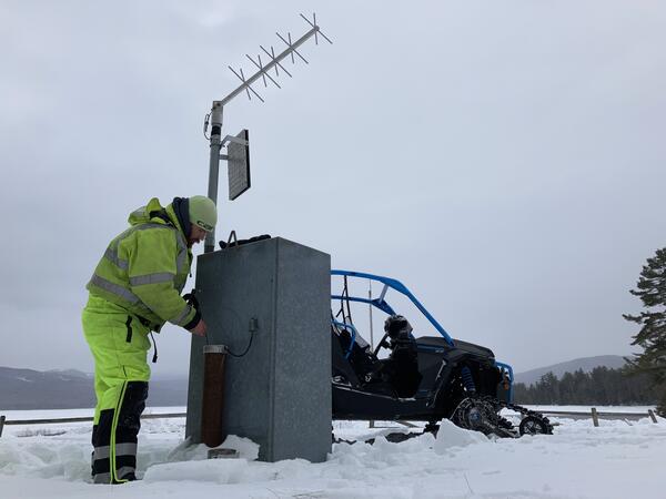
Groundwater Science in the Snow
No matter the season, groundwater science continues! In this March photo, Hydrologic Technician Jeremiah Pomerleau is making groundwater measurements and inspecting the USGS groundwater site monitoring equipment. Due to snowy terrain, Pomerleau used a utility terrain vehicle (UTV) to access the well, requiring a trek of about 15 miles from the main road.
By
Winter Groundwater Comparisons at Middle Dam, Maine
Hydrologic technician making groundwater measurements and inspecting the USGS groundwater site monitoring equipment.
Hydrologic technician making groundwater measurements and inspecting the USGS groundwater site monitoring equipment.

Modern equipment currently in use at a streamgage on the Ogden River
Modern equipment currently in use at the South Fork of the Ogden River streamgage, to include; an electronic data logger, pressure transducer and GOES radio. This streamgage has been monitoring water levels and flow since March 21, 1921, making it one of 25 centennial gauges in Utah. The equipment used to collect data has changed significantly over the pas
Modern equipment currently in use at the South Fork of the Ogden River streamgage, to include; an electronic data logger, pressure transducer and GOES radio. This streamgage has been monitoring water levels and flow since March 21, 1921, making it one of 25 centennial gauges in Utah. The equipment used to collect data has changed significantly over the pas

Description of the South Fork of the Ogden River streamgage
Description of the South Fork of the Ogden River streamgage included in USGS Water-Supply Paper 530 "Surface Water Supply of the United States, 1921, Part X.
Description of the South Fork of the Ogden River streamgage included in USGS Water-Supply Paper 530 "Surface Water Supply of the United States, 1921, Part X.

100-Year Flood - It's All About Chance
100-Year Flood - It's All About Chance poster image
100-Year Flood - It's All About Chance poster image

January 2021 USGS Active Groundwater Level Network Animation
The USGS Active Groundwater Level Network includes about 20,000 wells that have been measured by the USGS or USGS cooperators at least once within the past 13 months. The animation shows a daily snapshot of water-level statistics in the network for January 2021.
The USGS Active Groundwater Level Network includes about 20,000 wells that have been measured by the USGS or USGS cooperators at least once within the past 13 months. The animation shows a daily snapshot of water-level statistics in the network for January 2021.

Airborne electromagnetic survey, northeastern Wisconsin, January 2021
Photo of helicopter with geophysical equipment loop deployed below it via slingload. In January 2021 a helicopter carried an airborne electromagnetic induction sensor over parts of northeastern Wisconsin as part of a USGS study to map the aquifers in the region.
Photo of helicopter with geophysical equipment loop deployed below it via slingload. In January 2021 a helicopter carried an airborne electromagnetic induction sensor over parts of northeastern Wisconsin as part of a USGS study to map the aquifers in the region.

January 4, 2021, Below Normal Groundwater Levels Network
Map indicates groundwater sites within the USGS Active Groundwater Level network where the most recent groundwater-level measurement is in the 24th percentile or lower in the month of measurement over the period of record for the well.
Map indicates groundwater sites within the USGS Active Groundwater Level network where the most recent groundwater-level measurement is in the 24th percentile or lower in the month of measurement over the period of record for the well.

Freshwater Flow into Chesapeake Bay
High levels of nutrients and sediment can degrade the health of rivers and downstream bodies of water. In this photo of the Rivanna River in Virginia, large amounts of sediment are suspended in the river's water. The Rivanna River flows into the Chesapeake Bay, and too much sediment and/or nutrients can endanger the health of the Bay.
High levels of nutrients and sediment can degrade the health of rivers and downstream bodies of water. In this photo of the Rivanna River in Virginia, large amounts of sediment are suspended in the river's water. The Rivanna River flows into the Chesapeake Bay, and too much sediment and/or nutrients can endanger the health of the Bay.