


Water is one of America's greatest assets, providing energy, irrigation for crops, and water for homes and businesses. But water isn't always safe or reliable, and damages are costly. To protect lives and keep our country prosperous, we need information on the state of our water resources. USGS collects and delivers the water data our nation needs.
To manage our water resources effectively, we need to understand how much water is available and its usefulness. The USGS monitors the nation’s water resources through various national observing networks that use a range of technologies and methods to assess real-time water conditions and predict future changes in water availability for human and ecological uses.
Water Monitoring Network Links
Water Monitoring Network Links
Learn more about the monitoring networks that collect data on the nation's water resources including surface water, groundwater, water quality, and atmospheric data:
Water Data for the Nation
Water Data for the Nation

Access data from our national water networks on the USGS Water Data for the Nation website.
National Water Dashboard
National Water Dashboard

The National Water Dashboard combines real-time USGS water data with datasets from our federal partners.
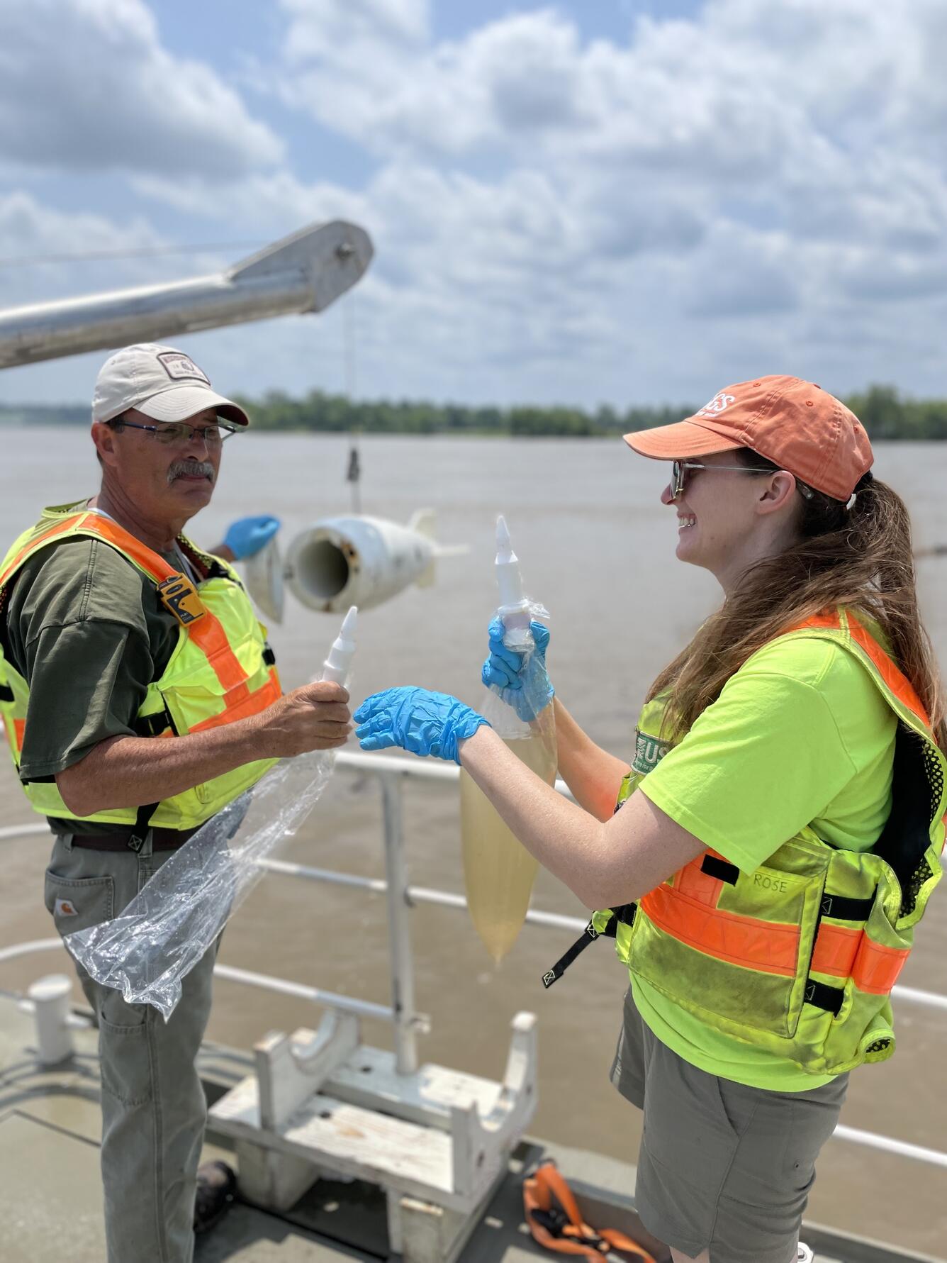
The USGS National Water Monitoring Network is a set of water data collection networks that support the USGS mission to protect life, property, the environment, and the nation’s economy. To assess current water conditions and availability for human and ecological uses, and to forecast future changes, the USGS monitors key components of the water cycle—specifically surface water, groundwater, and atmospheric processes—at many locations across the country using consistent approaches and methods. This “network of networks” provides high-quality data about the nation’s water resources, which stakeholders and partners rely on to make informed water resource decisions at the federal, state, and local levels.


Sources/Usage: Public Domain. View Media Details
How do we monitor water?
We select monitoring locations and technologies based on various needs, including water resource type, environmental conditions, monitoring frequency, data-collection methods, access to power and communications, personnel safety, and more. For example, we may install a real-time streamgage near a flood-prone bridge to alert local emergency officials when conditions are dangerous. Our scientists may even cross-country ski to remote Rocky Mountains sites to manually measure snow depth, helping us understand how winter precipitation affects snowpack and downstream water availability.
Water monitoring can be automated using sensors at fixed locations that continuously record and transmit data, or it can be done manually to obtain single measurements. Many sites, like our Centennial streamgages with over 100 years of data, provide continuous monitoring to compare current conditions with historical baselines. In some cases, we monitor a location for just a few years, at a certain time of year, or for short periods during events like floods or droughts to address a specific scientific question.
USGS staff are trained to measure and document methods while ensuring the quality of water data using consistent national standards. Even at automated sites, our scientists routinely to verify the accuracy and timeliness of the data. Real-time data are automatically checked for errors and released as “provisional” data until our scientists review and finalized them for publication.
What is the USGS National Water Monitoring Network?
The USGS National Water Monitoring Network provides fundamental datasets for water science, collected through monitoring and sampling. It operates consistently across the country using standardized data collection and quality-assurance protocols, allowing for comparisons of water data from different states, like Oregon and Tennessee, and over time, including the past 50 years. This network also serves as a consistent reference for other data collection efforts.
You can access data from the USGS National Water Monitoring Network through the USGS Water Data for the Nation website and web services.
Why do we call it a “network of networks”?
The USGS National Water Monitoring Network is a "network of networks" made up of several national water observing networks that monitor different aspects of water quality and quantity. The National Streamgaging Network includes over 11,000 sites for collecting water quantity data, while the National Water Quality Network has more than 100 river locations and over 2,000 groundwater wells where water quality data is collected. Each part of the network follows specific design criteria to fulfill its purpose.
Media

Sources/Usage: Public Domain. View Media Details
This network can also be enhanced by USGS regional and local monitoring activities, which use the same protocols but focus on specific needs in collaboration with local partners. For example, fixed-site monitoring can be supplemented with manually collected data or short-term deployments of specialized sensors for particular studies or events.
How is the USGS National Water Monitoring Network funded?
Funding for the USGS National Water Monitoring Network comes from a mix of federal appropriations and cooperative partners, including other federal agencies and state/local partners. This approach ensures that stakeholder interests are represented at all levels. The network is the foundation for the Groundwater and Streamflow Information Program (GWSIP) and the National Water Quality Program (NWQP).
While the backbone of the National Water Monitoring Network is primarily funded through federal appropriations, many sites are supported by partnerships to address regional and local data needs. The USGS National Water Monitoring Network and its components are coordinated by the USGS Water Resources Mission Area's Observing Systems Division.
What is the Next Generation Water Observing System (NGWOS)?
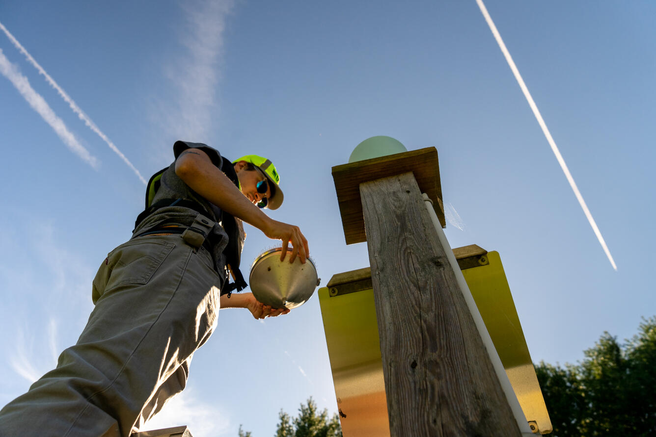
The focus of the Next-Generation Water Observing Systems (NGWOS) Program aims to modernize water monitoring networks by integrating new technologies, such as advanced webcams and ground- and space-based sensors. NGWOS collaborates with universities and the private sector to identify, develop, and evaluate innovative water monitoring technologies and methods that enhance operational efficiency and improve the USGS national hydrologic monitoring network and data delivery tools. The improvements can increase the spatial and temporal resolution of the monitoring network, providing water managers and stakeholders with better information for informed decision making.
Media

Sources/Usage: Public Domain. View Media Details
Authorizations
USGS activities are conducted under the authority of various pieces of authorizing federal legislation. The following is a subset of authorizations that are related to the overall National Water Monitoring Network and all of its sub-networks:
43 U.S.C. § 31 | The Organic Act of March 3, 1879 (20 Stat. 394)
The Organic Act of March 3, 1879, as amended, establishes the United States Geological Survey (USGS). Provides, among other matters, that the USGS is directed to classify the public lands and examine the geological structure, mineral resources, and products within and outside the national domain. Establishes the Office of the Director of the United States Geological Survey under the Department of the Interior. The Director is appointed by the President by and with the advice and consent of the Senate.
The Economy Act of 1932, as amended (31 U.S.C. 1535) authorizes any agency to obtain goods and services from and reimburse any other agency if certain criteria are met.
43 U.S.C. § 36(b); § 50; § 50b | Appropriations Act (Pub. L. 118-42; Pub. L. 99-500; Pub. L. 77-842; Pub. L. 86-406)
Authorizes the implementation of the USGS Cooperative Matching Funds as they are used to partner with over 1,600 State, regional, and local agencies.
Here is a full list of Groundwater and Streamflow Information Program authorizations.
Please visit the individual Network pages for more specific authorities.
Federal Priority Streamgages (FPS)
Federal Priority Streamgages (FPS) are automated stations that monitor water conditions in streams and rivers throughout the country. Originally established in 1999, these are important for meeting specific long-term needs of the Nation. The FPS Network was recently re-prioritized which resulted in size of the network increasing to nearly 12,400 locations.
Climate Response Network
The USGS groundwater Climate Response Network is a national network of wells selected to monitor natural groundwater-level conditions in unconfined or near-surface confined aquifers that are minimally affected by pumping or other human-induced stresses.
USGS National Water Quality Network
Understanding the quality of U.S. streams, rivers, and groundwater requires consistent data collection and analysis over decades for proper context of current conditions. The USGS collects nationally standardized data and information as part of the National Water Quality Network (NWQN). The NQWN is made up of sites across the Nation where USGS scientists regularly measure water-quality conditions.
USGS National Streamgaging Network
As of October 2024, the USGS Groundwater and Streamflow Information Program supports the collection and (or) delivery of both streamflow and water-level information at 8,705 sites and water-level information alone at 3,460 additional sites. The data are served online—most in near real-time—to meet many diverse needs including the protection of life, property, the environment, and our economy.
National Atmospheric Deposition Program (NADP)
The National Atmospheric Deposition Program (NADP) is a collaboration of atmospheric monitoring networks. The purpose of the networks is to collect data to evaluate air quality. Network data also inform science-based actions to protect human health and preserve ecosystems for current and future generations. The NADP National Trends Network (NTN) quantifies the concentration of eight major ions and...

Water Data Keep Us Strong
Water is one of America's greatest assets, providing energy, irrigation for crops, and water for homes and businesses. But water isn't always safe or reliable, and damages are costly. To protect lives and keep our country prosperous, we need information on the state of our water resources. USGS collects and delivers the water data our nation needs.
To manage our water resources effectively, we need to understand how much water is available and its usefulness. The USGS monitors the nation’s water resources through various national observing networks that use a range of technologies and methods to assess real-time water conditions and predict future changes in water availability for human and ecological uses.
Water Monitoring Network Links
Water Monitoring Network Links
Learn more about the monitoring networks that collect data on the nation's water resources including surface water, groundwater, water quality, and atmospheric data:
Water Data for the Nation
Water Data for the Nation
Access data from our national water networks on the USGS Water Data for the Nation website.
National Water Dashboard
National Water Dashboard
The National Water Dashboard combines real-time USGS water data with datasets from our federal partners.
The USGS National Water Monitoring Network is a set of water data collection networks that support the USGS mission to protect life, property, the environment, and the nation’s economy. To assess current water conditions and availability for human and ecological uses, and to forecast future changes, the USGS monitors key components of the water cycle—specifically surface water, groundwater, and atmospheric processes—at many locations across the country using consistent approaches and methods. This “network of networks” provides high-quality data about the nation’s water resources, which stakeholders and partners rely on to make informed water resource decisions at the federal, state, and local levels.
Sources/Usage: Public Domain. View Media Details
How do we monitor water?
We select monitoring locations and technologies based on various needs, including water resource type, environmental conditions, monitoring frequency, data-collection methods, access to power and communications, personnel safety, and more. For example, we may install a real-time streamgage near a flood-prone bridge to alert local emergency officials when conditions are dangerous. Our scientists may even cross-country ski to remote Rocky Mountains sites to manually measure snow depth, helping us understand how winter precipitation affects snowpack and downstream water availability.
Water monitoring can be automated using sensors at fixed locations that continuously record and transmit data, or it can be done manually to obtain single measurements. Many sites, like our Centennial streamgages with over 100 years of data, provide continuous monitoring to compare current conditions with historical baselines. In some cases, we monitor a location for just a few years, at a certain time of year, or for short periods during events like floods or droughts to address a specific scientific question.
USGS staff are trained to measure and document methods while ensuring the quality of water data using consistent national standards. Even at automated sites, our scientists routinely to verify the accuracy and timeliness of the data. Real-time data are automatically checked for errors and released as “provisional” data until our scientists review and finalized them for publication.
What is the USGS National Water Monitoring Network?
The USGS National Water Monitoring Network provides fundamental datasets for water science, collected through monitoring and sampling. It operates consistently across the country using standardized data collection and quality-assurance protocols, allowing for comparisons of water data from different states, like Oregon and Tennessee, and over time, including the past 50 years. This network also serves as a consistent reference for other data collection efforts.
You can access data from the USGS National Water Monitoring Network through the USGS Water Data for the Nation website and web services.
Why do we call it a “network of networks”?
The USGS National Water Monitoring Network is a "network of networks" made up of several national water observing networks that monitor different aspects of water quality and quantity. The National Streamgaging Network includes over 11,000 sites for collecting water quantity data, while the National Water Quality Network has more than 100 river locations and over 2,000 groundwater wells where water quality data is collected. Each part of the network follows specific design criteria to fulfill its purpose.
Media
Sources/Usage: Public Domain. View Media Details
This network can also be enhanced by USGS regional and local monitoring activities, which use the same protocols but focus on specific needs in collaboration with local partners. For example, fixed-site monitoring can be supplemented with manually collected data or short-term deployments of specialized sensors for particular studies or events.
How is the USGS National Water Monitoring Network funded?
Funding for the USGS National Water Monitoring Network comes from a mix of federal appropriations and cooperative partners, including other federal agencies and state/local partners. This approach ensures that stakeholder interests are represented at all levels. The network is the foundation for the Groundwater and Streamflow Information Program (GWSIP) and the National Water Quality Program (NWQP).
While the backbone of the National Water Monitoring Network is primarily funded through federal appropriations, many sites are supported by partnerships to address regional and local data needs. The USGS National Water Monitoring Network and its components are coordinated by the USGS Water Resources Mission Area's Observing Systems Division.
What is the Next Generation Water Observing System (NGWOS)?
The focus of the Next-Generation Water Observing Systems (NGWOS) Program aims to modernize water monitoring networks by integrating new technologies, such as advanced webcams and ground- and space-based sensors. NGWOS collaborates with universities and the private sector to identify, develop, and evaluate innovative water monitoring technologies and methods that enhance operational efficiency and improve the USGS national hydrologic monitoring network and data delivery tools. The improvements can increase the spatial and temporal resolution of the monitoring network, providing water managers and stakeholders with better information for informed decision making.
Media
Sources/Usage: Public Domain. View Media Details
Authorizations
USGS activities are conducted under the authority of various pieces of authorizing federal legislation. The following is a subset of authorizations that are related to the overall National Water Monitoring Network and all of its sub-networks:
43 U.S.C. § 31 | The Organic Act of March 3, 1879 (20 Stat. 394)
The Organic Act of March 3, 1879, as amended, establishes the United States Geological Survey (USGS). Provides, among other matters, that the USGS is directed to classify the public lands and examine the geological structure, mineral resources, and products within and outside the national domain. Establishes the Office of the Director of the United States Geological Survey under the Department of the Interior. The Director is appointed by the President by and with the advice and consent of the Senate.
The Economy Act of 1932, as amended (31 U.S.C. 1535) authorizes any agency to obtain goods and services from and reimburse any other agency if certain criteria are met.
43 U.S.C. § 36(b); § 50; § 50b | Appropriations Act (Pub. L. 118-42; Pub. L. 99-500; Pub. L. 77-842; Pub. L. 86-406)
Authorizes the implementation of the USGS Cooperative Matching Funds as they are used to partner with over 1,600 State, regional, and local agencies.
Here is a full list of Groundwater and Streamflow Information Program authorizations.
Please visit the individual Network pages for more specific authorities.
Federal Priority Streamgages (FPS)
Federal Priority Streamgages (FPS) are automated stations that monitor water conditions in streams and rivers throughout the country. Originally established in 1999, these are important for meeting specific long-term needs of the Nation. The FPS Network was recently re-prioritized which resulted in size of the network increasing to nearly 12,400 locations.
Climate Response Network
The USGS groundwater Climate Response Network is a national network of wells selected to monitor natural groundwater-level conditions in unconfined or near-surface confined aquifers that are minimally affected by pumping or other human-induced stresses.
USGS National Water Quality Network
Understanding the quality of U.S. streams, rivers, and groundwater requires consistent data collection and analysis over decades for proper context of current conditions. The USGS collects nationally standardized data and information as part of the National Water Quality Network (NWQN). The NQWN is made up of sites across the Nation where USGS scientists regularly measure water-quality conditions.
USGS National Streamgaging Network
As of October 2024, the USGS Groundwater and Streamflow Information Program supports the collection and (or) delivery of both streamflow and water-level information at 8,705 sites and water-level information alone at 3,460 additional sites. The data are served online—most in near real-time—to meet many diverse needs including the protection of life, property, the environment, and our economy.
National Atmospheric Deposition Program (NADP)
The National Atmospheric Deposition Program (NADP) is a collaboration of atmospheric monitoring networks. The purpose of the networks is to collect data to evaluate air quality. Network data also inform science-based actions to protect human health and preserve ecosystems for current and future generations. The NADP National Trends Network (NTN) quantifies the concentration of eight major ions and...
Water Data Keep Us Strong
Water is one of America's greatest assets, providing energy, irrigation for crops, and water for homes and businesses. But water isn't always safe or reliable, and damages are costly. To protect lives and keep our country prosperous, we need information on the state of our water resources. USGS collects and delivers the water data our nation needs.
Water is one of America's greatest assets, providing energy, irrigation for crops, and water for homes and businesses. But water isn't always safe or reliable, and damages are costly. To protect lives and keep our country prosperous, we need information on the state of our water resources. USGS collects and delivers the water data our nation needs.