
A view of Horseshoe Falls from the Canadian side of Niagara Falls.
Images
Total: 0
Settings
Total: 0
Explore our planet through photography and imagery, including climate change and water all the way back to the 1800s when the USGS was surveying the country by horse and buggy.
Filter Total Items: 21537

Horseshoe Falls
A view of Horseshoe Falls from the Canadian side of Niagara Falls.

International Border at Niagara Falls
The international border at Niagara Falls.
The international border at Niagara Falls.

Niagara River Rapids
A view of rapids on the Niagara River, just upstream of American Falls.
A view of rapids on the Niagara River, just upstream of American Falls.

Niagara River Rapids
A view of rapids on the Niagara River, just upstream of American Falls.
A view of rapids on the Niagara River, just upstream of American Falls.

Panorama of American and Horseshoe Falls in Niagara Falls
A panorama of American and Horseshoe Falls in Niagara Falls from the Canadian side of the waterfall.
A panorama of American and Horseshoe Falls in Niagara Falls from the Canadian side of the waterfall.

Sediment Plume downstream of Niagara Falls
A natural plume of dissolved sediments just downstream from Niagara Falls. As water travels through rock and soil, it dissolves sediments. This plume then emerges downstream from the main falls.
A natural plume of dissolved sediments just downstream from Niagara Falls. As water travels through rock and soil, it dissolves sediments. This plume then emerges downstream from the main falls.

Stagecoach Lake, Steamboat, Colorado
Sunset at Stagecoach Lake, Steamboat, Colorado
Sunset at Stagecoach Lake, Steamboat, Colorado

The quality of the water we drink can inpact our health
The quality of the water we drink can inpact our health.
The quality of the water we drink can inpact our health.

Sagebrush seedlings in Birds of Prey National Conservation Area
Sagebrush seedlings grown at Birds of Prey National Conservation Area before outplanting to sites at BOP NCA in Nov 2012 in sites previously burned in wildfire summer 2012
Sagebrush seedlings grown at Birds of Prey National Conservation Area before outplanting to sites at BOP NCA in Nov 2012 in sites previously burned in wildfire summer 2012

Savannah Sparrow on a hummock in dwarf shrub meadow habitat
Savannah Sparrow on a hummock in dwarf shrub meadow habitat. This photo was taken on the Seward Peninsula as part of the Changing Arctic Ecosystem Boreal-Arctic Transition Zone program.
Savannah Sparrow on a hummock in dwarf shrub meadow habitat. This photo was taken on the Seward Peninsula as part of the Changing Arctic Ecosystem Boreal-Arctic Transition Zone program.

Savannah Sparrow sitting on a hummock in dwarf shrub meadow habitat
Savannah Sparrow sitting on a hummock in dwarf shrub meadow habitat. This photo was taken on the Seward Peninsula as part of the Changing Arctic Ecosystem Boreal-Arctic Transition Zone program.
Savannah Sparrow sitting on a hummock in dwarf shrub meadow habitat. This photo was taken on the Seward Peninsula as part of the Changing Arctic Ecosystem Boreal-Arctic Transition Zone program.

Whimbrel feeding on a hummock of dwarf shrub meadow habitat
Whimbrel feeding on a hummock of dwarf shrub meadow habitat.
Whimbrel feeding on a hummock of dwarf shrub meadow habitat.

Whimbrel in dwarf shrub meadow habitat on the Seward Peninsula, Alaska
Whimbrel in dwarf shrub meadow habitat on the Seward Peninsula, Alaska.
Whimbrel in dwarf shrub meadow habitat on the Seward Peninsula, Alaska.

CERC Scientists Operate a Sediment Sampler on the Yellowstone River
A USGS scientist operates a Petite Ponar substrate sampler to sample bed material in an area identified as a pallid sturgeon spawning location on the Yellowstone River, North Dakota.
A USGS scientist operates a Petite Ponar substrate sampler to sample bed material in an area identified as a pallid sturgeon spawning location on the Yellowstone River, North Dakota.

Close-up Sample
A close-up image of lignite-dominated gravel sampled from a spawning area with Petite Ponar sampler.
A close-up image of lignite-dominated gravel sampled from a spawning area with Petite Ponar sampler.

Collecting Surface Water Samples in the Rabenberg Waterfowl Protection
Two USGS scientists collecting surface water samples in the Rabenberg Waterfowl Protection Area, Montana, as part of an effort to study if historic oil and gas production in the Williston Basin has impacted amphibians in the Prairie Pothole Region.
Two USGS scientists collecting surface water samples in the Rabenberg Waterfowl Protection Area, Montana, as part of an effort to study if historic oil and gas production in the Williston Basin has impacted amphibians in the Prairie Pothole Region.

Petite Ponar Sampler and Sample
Collecting and storing substrate samples using a Petite Ponar sampler (top right) for later analysis.
Collecting and storing substrate samples using a Petite Ponar sampler (top right) for later analysis.
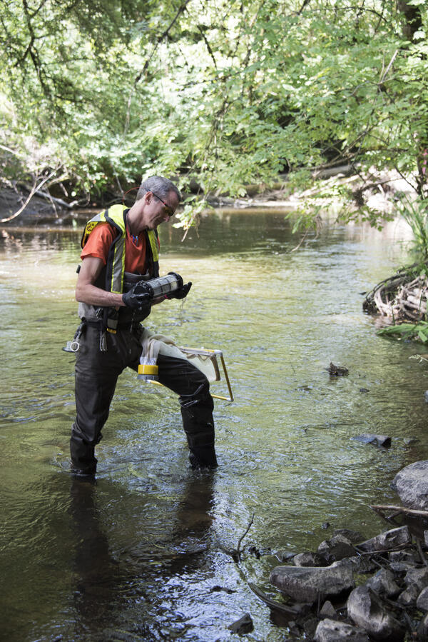
A USGS researcher takes algae samples at Bear Creek in Redmond, WA.
A USGS researcher takes algae samples at Bear Creek in Redmond, Washington.
A USGS researcher takes algae samples at Bear Creek in Redmond, Washington.

Fire ecologists record post-fire information
Fire ecologists record post-fire information on tree mortality, fuel consumption, and vegetation communities to better understand and predict fire impacts, Kenai National Wildlife Refuge, AK
Fire ecologists record post-fire information on tree mortality, fuel consumption, and vegetation communities to better understand and predict fire impacts, Kenai National Wildlife Refuge, AK

Salmonid in a Pacific Northwest Stream
Salmonids are inventoried during the ecosurveys done for the Regional Stream Quality Assessment (RSQA)
Salmonids are inventoried during the ecosurveys done for the Regional Stream Quality Assessment (RSQA)

White River near Interior, SD
USGS student trainee assists with the collection of a streamflow measurement on June 24, 2015, on the White River near Interior, SD (streamgage 06446500). Streamflow was about 2,500 cubic feet per second.
USGS student trainee assists with the collection of a streamflow measurement on June 24, 2015, on the White River near Interior, SD (streamgage 06446500). Streamflow was about 2,500 cubic feet per second.