
An endangered mountain yellow-legged frog (Rana muscosa).
Images
Total: 0
Settings
Total: 0
Explore our planet through photography and imagery, including climate change and water all the way back to the 1800s when the USGS was surveying the country by horse and buggy.
Filter Total Items: 21537

Endangered Mountain Yellow-Legged Frog (Rana muscosa)
An endangered mountain yellow-legged frog (Rana muscosa).

John Redmond Reservoir
A USGS vehicle is parked next to a sign that reads, "Notice Coast Guard Approved Personal Flotation Devices Must Be Worn WHEN IN WATER Beyond This Point". In the background the John Redmond Reservoir spillway can be seen.
A USGS vehicle is parked next to a sign that reads, "Notice Coast Guard Approved Personal Flotation Devices Must Be Worn WHEN IN WATER Beyond This Point". In the background the John Redmond Reservoir spillway can be seen.

Neosho River at Burlingame
Photo of side view of a bridge crossing the murky brown Neosho River. Greenery covers both banks of the river.
Photo of side view of a bridge crossing the murky brown Neosho River. Greenery covers both banks of the river.

Snow geese and Black Brant fight over nesting territories
Two snow geese and a single black brant goose fight over nesting territories on the Colville River Delta in Alaska.
Two snow geese and a single black brant goose fight over nesting territories on the Colville River Delta in Alaska.

Assessing the severity of the Funny River fire on the Kenai Peninsula
Pre- and post-fire measurements of fire effects help ecologists, fire scientists, and managers determine how the severity of wildfires affects plants, animal habitat, and ecosystem services.
Pre- and post-fire measurements of fire effects help ecologists, fire scientists, and managers determine how the severity of wildfires affects plants, animal habitat, and ecosystem services.

Black Brant flying near the Colville River, northern Alaska
Black Brant flying near the Colville River, northern Alaska.
Black Brant flying near the Colville River, northern Alaska.

Reburns are becoming more common in many parts of Alaska
Reburns, or fires that burn more frequently than expected, are becoming more common in Alaska and can cause major changes in vegetation composition, wildlife habitat, and landscape resilience
Reburns, or fires that burn more frequently than expected, are becoming more common in Alaska and can cause major changes in vegetation composition, wildlife habitat, and landscape resilience

San Pedro Riparian National Conservation Area
Photograph showing San Pedro Riparian National Conservation Area, residential development southeast of Sierra Vista, Arizona, and the Huachuca Mountains from Hereford Road, Cochise County, Arizona.
Photograph showing San Pedro Riparian National Conservation Area, residential development southeast of Sierra Vista, Arizona, and the Huachuca Mountains from Hereford Road, Cochise County, Arizona.

The top of Tusuk Channel on the Pilgrim River
Near the top of the Tusuk Channel of the Pilgrim River.
Near the top of the Tusuk Channel of the Pilgrim River.

Biologists Collecting Biological Samples from Grizzly Bear
USGS biologists collecting biological information from a grizzly bear they have captured. Biologists collect hair samples for genetic analysis, weigh the bear, and gather numerous measurements of the body, such as the head, paws, claws, teeth, etc. Overall condition of the bear is assessed as well, including a body fat measurement.
USGS biologists collecting biological information from a grizzly bear they have captured. Biologists collect hair samples for genetic analysis, weigh the bear, and gather numerous measurements of the body, such as the head, paws, claws, teeth, etc. Overall condition of the bear is assessed as well, including a body fat measurement.

Low-Level Flights in Southeast Missouri Will Look at Geology and Mineral Resources
A Piper Navajo airplane with auxiliary wingtip pods and tail stinger magnetometers will study the rocks within the St. Francois Mountains in southeast Missouri.
A Piper Navajo airplane with auxiliary wingtip pods and tail stinger magnetometers will study the rocks within the St. Francois Mountains in southeast Missouri.

Memorial Day Flood in Texas
Road and bridge damage on the Blanco River near Blanco, Texas, from the Memorial Day 2015 Flood.
Road and bridge damage on the Blanco River near Blanco, Texas, from the Memorial Day 2015 Flood.

Rock Slide in Nepal from an Earthquake in April of 2015
Villagers in Kerauja below a rock slide that resulted from a magnitude 7.8 earthquake on April 25, 2015 in Gorkha district, Nepal.
Villagers in Kerauja below a rock slide that resulted from a magnitude 7.8 earthquake on April 25, 2015 in Gorkha district, Nepal.

Piping Plover Nest
USGS scientists are working to model shorebird habitat availability both today and in the future, given processes like sea-level rise, in an effort to support the efficient management of beaches for both people and nesting shorebirds.
USGS scientists are working to model shorebird habitat availability both today and in the future, given processes like sea-level rise, in an effort to support the efficient management of beaches for both people and nesting shorebirds.
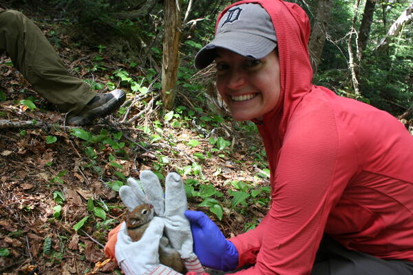
Toni Lyn Morelli trapping red squirrels
Toni Lyn Morelli; White Mountain National Forest, NH; trapping red squirrels
Toni Lyn Morelli; White Mountain National Forest, NH; trapping red squirrels

Douglas-fir trees topped to create snags for wildlife habitat
Snags provide habitat for a wide range of organisms from cavity-nesting birds to insects, and are critical for maintaining forest biodiversity. Resource managers can create snags by topping trees to mitigate loss of snags to timber harvest, but information regarding changes in habitat for snag-dependent wildlife over time as created snags decay is lacking.
Snags provide habitat for a wide range of organisms from cavity-nesting birds to insects, and are critical for maintaining forest biodiversity. Resource managers can create snags by topping trees to mitigate loss of snags to timber harvest, but information regarding changes in habitat for snag-dependent wildlife over time as created snags decay is lacking.

Songbird surveys in McDonald Dunn forest
Joan Hagar and Amy Comstock assess the long-term ecological value and characteristics of snags created for wildlife
Joan Hagar and Amy Comstock assess the long-term ecological value and characteristics of snags created for wildlife

Tree in McDonald Dunn Forest
Joan Hagar and Amy Comstock assess the long-term ecological value and characteristics of snags created for wildlife
Joan Hagar and Amy Comstock assess the long-term ecological value and characteristics of snags created for wildlife

Recent activity highlights Kīlauea's restless nature
Kīlauea Volcano's summit lava lake dropped from nearly overflowing on April 26, 2015 (left), to about 62 m (203 ft) below the newly created (by multiple overflows) vent rim on May 15, 2015 (right). USGS photos.
Kīlauea Volcano's summit lava lake dropped from nearly overflowing on April 26, 2015 (left), to about 62 m (203 ft) below the newly created (by multiple overflows) vent rim on May 15, 2015 (right). USGS photos.

Using a bridge crane to measure streamflow, Powder River at Arvada
Using a bridge crane to measure streamflow, Powder River at Arvada
Using a bridge crane to measure streamflow, Powder River at Arvada

USGS Geologists Inspecting Fault Trace in a Trench
View of geologists pointing to fault in a trench dug across one of the ruptures from the 2014 South Napa earthquake. From front to rear: Alexandra Pickering, Suzanne Hecker, Aaron Page (all USGS). Trench located approximately 3 miles NW of downtown Napa, CA.
View of geologists pointing to fault in a trench dug across one of the ruptures from the 2014 South Napa earthquake. From front to rear: Alexandra Pickering, Suzanne Hecker, Aaron Page (all USGS). Trench located approximately 3 miles NW of downtown Napa, CA.