
A telephoto view of the northern vent fountain within Halema‘uma‘u crater. The steep septum separating the north and south fountains was under constant barrage today by molten lava falling from the fountains, with the steep walls on the inside of the cones in a state of constant dripping and flowing back into crater. USGS photo by M.
Images
Volcano Hazard Program images.
Filter Total Items: 6270

Episode 13 fountaining at Kīlauea summit
A telephoto view of the northern vent fountain within Halema‘uma‘u crater. The steep septum separating the north and south fountains was under constant barrage today by molten lava falling from the fountains, with the steep walls on the inside of the cones in a state of constant dripping and flowing back into crater. USGS photo by M.

Episode 13 fountaining at Kīlauea summit
A USGS geologist uses a handheld laser rangefinder to measure eruption features during the 13th episode of the Kīlauea summit eruption. USGS photo taken on March 11 from the western rim of Halema‘uma‘u by M. Patrick.
A USGS geologist uses a handheld laser rangefinder to measure eruption features during the 13th episode of the Kīlauea summit eruption. USGS photo taken on March 11 from the western rim of Halema‘uma‘u by M. Patrick.

Presentation: The Challenge of Volcano Monitoring, Eruption Forecasting, and Protecting Vulnerable Populations
linkThis presentation was prepared for the AGU 2024-2025 Distinguished Lecture Series. This, and other lectures, provide a high-level synthesis of different topics for general science audiences.
This presentation discusses the challenge of volcano monitoring, eruption forecasting, and protecting vulnerable populations.

December 30, 2024 Kīlauea summit eruption
A USGS Hawaiian Volcano Observatory geologist uses a laser rangefinder to collect fountain height measurements from the eruption within Halema‘uma‘u crater at the summit of Kīlauea volcano. Fountain heights reached approximately 30–35 m (100–115 ft) on the morning of December 30, 2024.
A USGS Hawaiian Volcano Observatory geologist uses a laser rangefinder to collect fountain height measurements from the eruption within Halema‘uma‘u crater at the summit of Kīlauea volcano. Fountain heights reached approximately 30–35 m (100–115 ft) on the morning of December 30, 2024.

Pre-dawn lava fountains and flows in Halema‘uma‘u crater
Photo of the lava fountains and flows within the western part of Halema‘uma‘u crater just before dawn on December 30, 2024. The lava fountains have started to build scoria cones around themselves with the fountains consistently reaching to 30 m (100 ft) high. These fountains are feeding lava flows that have covered the western quarter of the crater floor.
Photo of the lava fountains and flows within the western part of Halema‘uma‘u crater just before dawn on December 30, 2024. The lava fountains have started to build scoria cones around themselves with the fountains consistently reaching to 30 m (100 ft) high. These fountains are feeding lava flows that have covered the western quarter of the crater floor.

Close-up view of the lava fountains along the western wall of Halema‘uma‘u
A close-up photo taken just before dawn of the lava fountains in the western part of Halema‘uma‘u crater, at Kīlauea summit, on December 30, 2024. These lava fountains are consistently reaching 30 m (100 ft) high and building a spatter cone that is about 20 m (65 ft) high, 95 m (310 ft) long, and 60 m (200 ft) wide. Photo by U.S. Geological Survey geologist D.
A close-up photo taken just before dawn of the lava fountains in the western part of Halema‘uma‘u crater, at Kīlauea summit, on December 30, 2024. These lava fountains are consistently reaching 30 m (100 ft) high and building a spatter cone that is about 20 m (65 ft) high, 95 m (310 ft) long, and 60 m (200 ft) wide. Photo by U.S. Geological Survey geologist D.

Close-up view of lava flows within Halema‘uma‘u crater
Photo of the lava flows in the western part of Halema‘uma‘u crater just before dawn on December 30, 2024. These lava flows are reaching about 2,300 ft (or 700 m) from their source at the lava fountains and covering the pre-existing topography. The flows currently cover about a quarter of the western part of the crater floor. Photo by U.S.
Photo of the lava flows in the western part of Halema‘uma‘u crater just before dawn on December 30, 2024. These lava flows are reaching about 2,300 ft (or 700 m) from their source at the lava fountains and covering the pre-existing topography. The flows currently cover about a quarter of the western part of the crater floor. Photo by U.S.

Aerial view of the active and inactive parts of the December 2024 flow field
Aerial view looking to the southwest of the active and inactive parts of the eruption within Halema‘uma‘u crater at the summit of Kīlauea. The dark black lava in the foreground covered most of the crater floor on the first day of the eruption, starting around 2:20 a.m. on December 23, 2024.
Aerial view looking to the southwest of the active and inactive parts of the eruption within Halema‘uma‘u crater at the summit of Kīlauea. The dark black lava in the foreground covered most of the crater floor on the first day of the eruption, starting around 2:20 a.m. on December 23, 2024.

Fissure fountain from helicopter overflight on December 30
An Aerial view of two eruptive cones in the southwest corner of Halema‘uma‘u crater at Kīlauea's summit on the morning of December 30, 2024. The fissure fountains reached heights of approximately 30 meters (100 ft) and lava flows continue to cover a portion of the crater floor. USGS photo by H. Winslow.
An Aerial view of two eruptive cones in the southwest corner of Halema‘uma‘u crater at Kīlauea's summit on the morning of December 30, 2024. The fissure fountains reached heights of approximately 30 meters (100 ft) and lava flows continue to cover a portion of the crater floor. USGS photo by H. Winslow.

Active lava fountains and flows on December 30, 2024
Aerial view looking to the southwest of the active eruption in Halema‘uma‘u crater on December 30, 2024. The lava fountains are reaching up to 30 m (100 ft) high and feeding the incandescent lava in the foreground. The current activity is concentrated in the western quarter of the crater floor. Photo by U.S. Geological Survey geologist D. Downs.
Aerial view looking to the southwest of the active eruption in Halema‘uma‘u crater on December 30, 2024. The lava fountains are reaching up to 30 m (100 ft) high and feeding the incandescent lava in the foreground. The current activity is concentrated in the western quarter of the crater floor. Photo by U.S. Geological Survey geologist D. Downs.

Aerial view of lava fountains within Halema‘uma‘u, December 30, 2024
This aerial photo was captured during a USGS Hawaiian Volcano Observatory overflight on the morning of Monday, December 30, 2024, providing a south-looking telephoto overhead view of the lava fountains within Halema‘uma‘u at Kīlauea's summit. USGS photo by N. Deligne.
This aerial photo was captured during a USGS Hawaiian Volcano Observatory overflight on the morning of Monday, December 30, 2024, providing a south-looking telephoto overhead view of the lava fountains within Halema‘uma‘u at Kīlauea's summit. USGS photo by N. Deligne.

Aerial overview of Kaluapele (Kīlauea summit caldera) and eruption within Halema‘uma‘u, December 30, 2024
linkThis aerial photo was captured during a USGS Hawaiian Volcano Observatory overflight on the morning of Monday, December 30, 2024, providing a southwest-looking overview of the ongoing Kīlauea summit eruption within Halema‘uma‘u. The lava fountains are visible in the center of the image, in the southwest corner of Halema‘uma‘u.

Aerial image of active lava fountains and lava flows at Halema‘uma‘u, Kīlauea, December 30, 2024
linkThis aerial photo was captured during a USGS Hawaiian Volcano Observatory overflight on the morning of Monday, December 30, 2024, providing a southwest-looking overview of the ongoing Kīlauea summit eruption within Halema‘uma‘u crater.

Low-angle view of active lava fountains within Halema‘uma‘u crater, Kīlauea, December 30, 2024
During a helicopter overflight on the morning of Monday, December 30, 2024, USGS Hawaiian Volcano Observatory geologists were provided a low-level view of the eruptive vents in the western wall of Halema‘uma‘u crater at Kīlauea's summit. USGS photo by N. Deligne.
During a helicopter overflight on the morning of Monday, December 30, 2024, USGS Hawaiian Volcano Observatory geologists were provided a low-level view of the eruptive vents in the western wall of Halema‘uma‘u crater at Kīlauea's summit. USGS photo by N. Deligne.

Aerial view of lava fountains within Halema‘uma‘u, Kīlauea, December 30, 2024
This oblique aerial photo was captured during a USGS Hawaiian Volcano Observatory overflight on the morning of Monday, December 30, 2024, providing a southwest-looking view of the active fountains of the ongoing eruption within Halema‘uma‘u at Kīlauea's summit. USGS photo by N. Deligne.
This oblique aerial photo was captured during a USGS Hawaiian Volcano Observatory overflight on the morning of Monday, December 30, 2024, providing a southwest-looking view of the active fountains of the ongoing eruption within Halema‘uma‘u at Kīlauea's summit. USGS photo by N. Deligne.

Annotated photo of lava flows and tephra deposits of the southwest portion of Kaluapele (Kīlauea caldera)
linkThis annotated image shows the lava flows and tephra deposits of the southwest portion of Kaluapele (Kīlauea's summit caldera). The photo was taken during a USGS Hawaiian Volcano Observatory overflight on the morning of Monday, December 30, 2024, with a view to the east.

Update on seismic activity at Mount Adams from September 2024 to early November 2024
Volcanoes tend to have seismicity that waxes and wanes over time. That’s considered normal and not necessarily a cause for concern. Let’s check on Mount Adams to see what USGS scientists are doing to learn more about its recent earthquake activity and what it could mean for this Cascade Range volcano.
Volcanoes tend to have seismicity that waxes and wanes over time. That’s considered normal and not necessarily a cause for concern. Let’s check on Mount Adams to see what USGS scientists are doing to learn more about its recent earthquake activity and what it could mean for this Cascade Range volcano.
Volcanic gas measurements during the 2024 Nāpau eruption
A USGS scientist aims the viewfinder of an infrared spectrometer to measure the chemistry of volcanic gas on the last day of the Nāpau eruption, September 20, 2024. USGS photo by P. Nadeau.
A USGS scientist aims the viewfinder of an infrared spectrometer to measure the chemistry of volcanic gas on the last day of the Nāpau eruption, September 20, 2024. USGS photo by P. Nadeau.

Shaded relief location map for the East Gallatin-Reese Creek fault system in northwest Yellowstone National Park
linkShaded relief location map for the East Gallatin-Reese Creek fault system (EGRCFS) in northwest Yellowstone National Park (YNP). The location of the EGRCFS is shown as mapped in the U.S.

USGS scientist Peter Kelly, recipient of the 2024 Dr. James R. Balsley Jr. Award for Excellence
linkUSGS scientist Peter Kelly is recognized for his work to design, optimize, and commercialize Multi-GAS technology for monitoring of geothermal and volcanic gas emanations. Notably, he spent almost a decade designing, engineering, and perfecting a system of geochemical sensors for both portable and semi-permanent remote deployment.

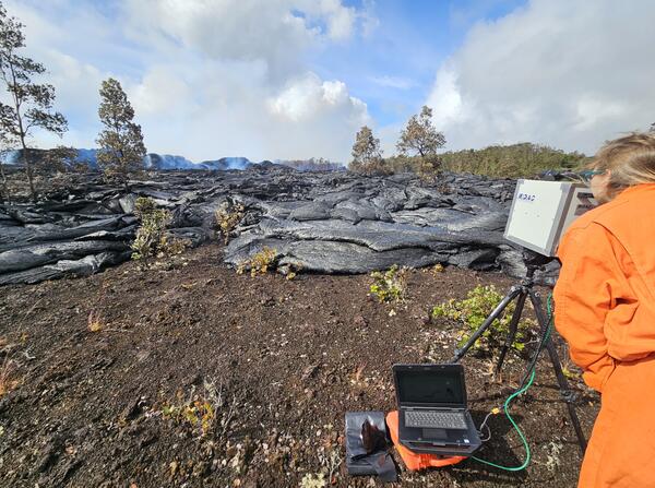
Geologist examines new lava flow from Kīlauea's Southwest Rift Zone eruption, June 4, 2024
The eruption on Kīlauea's Southwest Rift Zone remained paused on Tuesday, June 4, but Hawaiian Volcano Observatory geologists visited the area to take measurements of the previous day's lava flows. Here, a geologist examines part of the lava flow from fissure 2.
The eruption on Kīlauea's Southwest Rift Zone remained paused on Tuesday, June 4, but Hawaiian Volcano Observatory geologists visited the area to take measurements of the previous day's lava flows. Here, a geologist examines part of the lava flow from fissure 2.