
Geospatial Analyses and Applications Core Technology Team
Identifying Hazards and Risk
Attribution of weighted potential contaminant hazard ranks to understand potential contamination after major storm events.
PFAS in United States Tapwater
Mapping and web applications help communicate results and potential risk to the public.
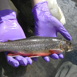
Sediment-Bound Contaminant Resiliency and Response
Methods to understand risk and prioritize sites in response to storm events.
Identification and inventory of contaminant sources on the landscape.
Chesapeake Bay Watershed maps showing density and locations of septic systems
Tablet-enabled field forms help coordinate field efforts.
About the Research
The Geospatial Analyses and Applications Core Technology Team (CTT) as part of the Environmental Health Program collaborates with teams across USGS to develop and apply geospatial analytical methods to answer broad-scale questions about source-sink and cause-effect relationships between contaminants and vulnerable communities.
The Geospatial Analyses and Applications CTT capitalizes on key variables of importance learned from past work in place-based activities.
The methods developed and used by this team are used to 1) develop new geospatial relationships to inform metric development, 2) map key variables across broad spatial extents, 3) apply relationships developed at local-scales to broad-scales via shared variables, and 4) investigate strength of broad relationships to feedback on place-based findings. These relationships can also be used to find locations similar to these place-based study sites, which may be useful for future site-selections or result extrapolation.

Because geospatial data tends to be multi-sourced, cumbersome, and often difficult to work with, the Geospatial CTT also has a strong background in database creation, organization, and upkeep, with an emphasis on adhering to and supporting ScienceBase and DOI data standards.
The team has also developed several online and tablet-based applications to coordinate field sampling efforts, track samples throughout their journey from the field to the lab(s), and provide rich visualizations to map, query, and access approved data. In the past, many projects have focused on place-based activities, conducting valuable science to gain a deep, nuanced understanding of the system under study.
More recently there has been a call for broadly focused, integrative science to support regional and national needs. Tools and methods developed by the Geospatial CTT are well suited for finding unique ways to translate place-based activities to broader needs.

Key Analytical Capabilities
- Study site selection and characterization
- Risk assessment – real vs. perceived
- Custom metric development
- Multivariate statistics
- Big-data analysis
- Landscape analysis
- Hydrological modelling and analysis
- Geomorphic assessment
- Lidar and Remote Sensing

Analytical Tools and Products
- Statistical analysis in R
- Field-form development
- Database design and development
- Geo-narratives and Web Applications
- ScienceBase and metadata creation
- ArcGIS, GRASS, Python, GitHub†
† Hypertext links to non-USGS products and services; and the use of trade names, trademarks, company names, or other references to non-USGS products and services are provided for information only and do not constitute endorsement or warranty by the U.S. Geological Survey (USGS), U.S. Department of the Interior, or U.S. Government.
Science Team Collaborators
-
Drinking Water and Wastewater Infrastructure Science Team
The team studies toxicants and pathogens in water resources from their sources, through watersheds, aquifers, and infrastructure to human and wildlife exposures. That information is used to develop decision tools that protect human and wildlife health.Fishing and Hunting Integrated Science Team
The Fishing and Hunting integrated science team focuses on contaminant and pathogen exposures in the environment that could impact the presence and vitality of fish and wildlife populations that drive commercial, recreational and subsistence activities such as hunting and fishing. If actual risks are identified this project will inform how to economically and effectively minimize risk by providing...Food Resources Lifecycle Integrated Science Team
The team studies the movement of toxicants and pathogens that could originate from the growing, raising, and processing/manufacturing of plant and animal products through the environment where exposure can occur. This information is used to understand if there are adverse effects upon exposure and to develop decision tools to protect health.Minerals Science Team
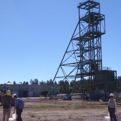
The Minerals Integrated Science Team focuses on contaminant exposures in the environment that might originate from mineral resource activities including, transportation, storage, extraction and waste management. Perceived health risks to humans and other organisms will be distinguished from actual risks, if any. If actual risks are identified the science produced by this team can inform how to...Per-and Polyfluoroalkyl Substances (PFAS) Integrated Science Team
Increasing scientific and public awareness of the widespread distribution of per- and poly-fluoroalkyl substances (PFAS) in U.S. drinking-water supplies, aquatic and terrestrial ecosystems, wildlife, and humans has raised many public health and resource management questions that U.S. Geological Survey's (USGS) science can inform. The USGS Environmental Health Program's PFAS Integrated Science Team...Energy Integrated Science Team
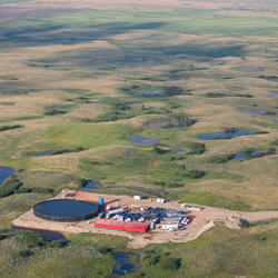
The Energy Lifecycle Integrated Science Team focuses on the potential for contaminant exposures in the environment that might originate from energy resource activities including, extraction, production, transportation, storage, extraction, waste management and restoration. Perceived health risks to humans and other organisms will be distinguished from actual risks, if any. If actual risks are...Toxins and Harmful Algal Blooms Science Team
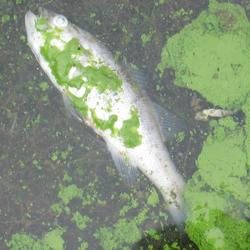
The team develops advanced methods to study factors driving algal toxin production, how and where wildlife or humans are exposed to toxins, and ecotoxicology. That information is used to develop decision tools to understand if toxin exposure leads to adverse health effects in order to protect human and wildlife health.Proxies Project
The Proxies Project is a series of studies to improve our understanding of water contaminants and water quality hazards. These studies develop models and technical approaches for estimating concentrations and assessing risk associated with: - harmful algal blooms (HABs) - per- and polyfluoroalkyl substances (PFAS) - 12 elements of concern (EoC)Colorado River Basin: Actionable and Strategic Integrated Science and Technology (ASIST)
Through the ASIST initiative, the USGS is leading the way in open science by bringing together scientists from different fields to collaborate closely with decision makers.


Multimedia items related to the Geospatial Analyses and Applications Core Technology Team can be found below.

Generalized schematic detailing the steps in the USGS decision support
Generalized schematic detailing the steps in the USGS decision support tool for prioritizing sampling locations based on perceived environmental hazards.
About the Research
The Geospatial Analyses and Applications Core Technology Team (CTT) as part of the Environmental Health Program collaborates with teams across USGS to develop and apply geospatial analytical methods to answer broad-scale questions about source-sink and cause-effect relationships between contaminants and vulnerable communities.
The Geospatial Analyses and Applications CTT capitalizes on key variables of importance learned from past work in place-based activities.
The methods developed and used by this team are used to 1) develop new geospatial relationships to inform metric development, 2) map key variables across broad spatial extents, 3) apply relationships developed at local-scales to broad-scales via shared variables, and 4) investigate strength of broad relationships to feedback on place-based findings. These relationships can also be used to find locations similar to these place-based study sites, which may be useful for future site-selections or result extrapolation.
Because geospatial data tends to be multi-sourced, cumbersome, and often difficult to work with, the Geospatial CTT also has a strong background in database creation, organization, and upkeep, with an emphasis on adhering to and supporting ScienceBase and DOI data standards.
The team has also developed several online and tablet-based applications to coordinate field sampling efforts, track samples throughout their journey from the field to the lab(s), and provide rich visualizations to map, query, and access approved data. In the past, many projects have focused on place-based activities, conducting valuable science to gain a deep, nuanced understanding of the system under study.
More recently there has been a call for broadly focused, integrative science to support regional and national needs. Tools and methods developed by the Geospatial CTT are well suited for finding unique ways to translate place-based activities to broader needs.
Key Analytical Capabilities
- Study site selection and characterization
- Risk assessment – real vs. perceived
- Custom metric development
- Multivariate statistics
- Big-data analysis
- Landscape analysis
- Hydrological modelling and analysis
- Geomorphic assessment
- Lidar and Remote Sensing
Analytical Tools and Products
- Statistical analysis in R
- Field-form development
- Database design and development
- Geo-narratives and Web Applications
- ScienceBase and metadata creation
- ArcGIS, GRASS, Python, GitHub†
† Hypertext links to non-USGS products and services; and the use of trade names, trademarks, company names, or other references to non-USGS products and services are provided for information only and do not constitute endorsement or warranty by the U.S. Geological Survey (USGS), U.S. Department of the Interior, or U.S. Government.
Science Team Collaborators
-
Drinking Water and Wastewater Infrastructure Science Team
The team studies toxicants and pathogens in water resources from their sources, through watersheds, aquifers, and infrastructure to human and wildlife exposures. That information is used to develop decision tools that protect human and wildlife health.Fishing and Hunting Integrated Science Team
The Fishing and Hunting integrated science team focuses on contaminant and pathogen exposures in the environment that could impact the presence and vitality of fish and wildlife populations that drive commercial, recreational and subsistence activities such as hunting and fishing. If actual risks are identified this project will inform how to economically and effectively minimize risk by providing...Food Resources Lifecycle Integrated Science Team
The team studies the movement of toxicants and pathogens that could originate from the growing, raising, and processing/manufacturing of plant and animal products through the environment where exposure can occur. This information is used to understand if there are adverse effects upon exposure and to develop decision tools to protect health.Minerals Science Team
The Minerals Integrated Science Team focuses on contaminant exposures in the environment that might originate from mineral resource activities including, transportation, storage, extraction and waste management. Perceived health risks to humans and other organisms will be distinguished from actual risks, if any. If actual risks are identified the science produced by this team can inform how to...Per-and Polyfluoroalkyl Substances (PFAS) Integrated Science Team
Increasing scientific and public awareness of the widespread distribution of per- and poly-fluoroalkyl substances (PFAS) in U.S. drinking-water supplies, aquatic and terrestrial ecosystems, wildlife, and humans has raised many public health and resource management questions that U.S. Geological Survey's (USGS) science can inform. The USGS Environmental Health Program's PFAS Integrated Science Team...Energy Integrated Science Team
The Energy Lifecycle Integrated Science Team focuses on the potential for contaminant exposures in the environment that might originate from energy resource activities including, extraction, production, transportation, storage, extraction, waste management and restoration. Perceived health risks to humans and other organisms will be distinguished from actual risks, if any. If actual risks are...Toxins and Harmful Algal Blooms Science Team
The team develops advanced methods to study factors driving algal toxin production, how and where wildlife or humans are exposed to toxins, and ecotoxicology. That information is used to develop decision tools to understand if toxin exposure leads to adverse health effects in order to protect human and wildlife health.Proxies Project
The Proxies Project is a series of studies to improve our understanding of water contaminants and water quality hazards. These studies develop models and technical approaches for estimating concentrations and assessing risk associated with: - harmful algal blooms (HABs) - per- and polyfluoroalkyl substances (PFAS) - 12 elements of concern (EoC)Colorado River Basin: Actionable and Strategic Integrated Science and Technology (ASIST)
Through the ASIST initiative, the USGS is leading the way in open science by bringing together scientists from different fields to collaborate closely with decision makers.
Multimedia items related to the Geospatial Analyses and Applications Core Technology Team can be found below.
Generalized schematic detailing the steps in the USGS decision support
Generalized schematic detailing the steps in the USGS decision support tool for prioritizing sampling locations based on perceived environmental hazards.