
Hydrologic technician Garret Welsh carries a large ice auger while walking across the frozen St. Croix river near streamgage 05341550 in Stillwater, Minnesota.
Images
Images intro.
Filter Total Items: 641

Carrying an ice auger on the St. Croix River at Stillwater, Minnesota
Hydrologic technician Garret Welsh carries a large ice auger while walking across the frozen St. Croix river near streamgage 05341550 in Stillwater, Minnesota.

Measuring stream velocity through an augered hole in the frozen St. Croix River, Minnesota
Hydrologic technician Garret Welsh conducts an Ice Rod measurement through an augered hole in the frozen St. Croix river near streamgage 05341550 in Stillwater, Minnesota. An Ice Rod is a heavy-duty, 1-inch (2.5 centimeter) diameter, lightweight aluminum rod used for suspending ice meters in fast velocities.
Hydrologic technician Garret Welsh conducts an Ice Rod measurement through an augered hole in the frozen St. Croix river near streamgage 05341550 in Stillwater, Minnesota. An Ice Rod is a heavy-duty, 1-inch (2.5 centimeter) diameter, lightweight aluminum rod used for suspending ice meters in fast velocities.

USGS and Partners install Underwater Acoustic Deterrent System in Lock 19 on the Mississippi River
linkScientists at the U.S. Geological Survey Upper Midwest Environmental Sciences Center and the U.S.
USGS and Partners install Underwater Acoustic Deterrent System in Lock 19 on the Mississippi River
linkScientists at the U.S. Geological Survey Upper Midwest Environmental Sciences Center and the U.S.

Visualization of an ensemble of solutions for PEST++
The left axis is a visualization of an ensemble of solutions (crosses and dashed lines) iteratively moving down gradient on an objective function surface (color flood) in 2-D parameters space, with the associated prior (gray) and posterior (blue) parameter marginal distributions shown on the two right stacked axes.
The left axis is a visualization of an ensemble of solutions (crosses and dashed lines) iteratively moving down gradient on an objective function surface (color flood) in 2-D parameters space, with the associated prior (gray) and posterior (blue) parameter marginal distributions shown on the two right stacked axes.

Bridge over channel between Fence Lake and Big Crawling Stone Lake in Lac du Flambeau Chain of Lakes, Wisconsin
linkBridge over channel between Fence Lake and Big Crawling Stone Lake in Lac du Flambeau Chain of Lakes, Wisconsin
Bridge over channel between Fence Lake and Big Crawling Stone Lake in Lac du Flambeau Chain of Lakes, Wisconsin
linkBridge over channel between Fence Lake and Big Crawling Stone Lake in Lac du Flambeau Chain of Lakes, Wisconsin

Dragonfly Mercury Project specimen collection in Glacier NP
Researchers instruct volunteers on how to collect dragonfly larvae in Glacier NP as a part of the Dragonfly Mercury Project.
Researchers instruct volunteers on how to collect dragonfly larvae in Glacier NP as a part of the Dragonfly Mercury Project.

Hydrologic Technician measuring streamflow using ADCP in Wisconsin
Hydrologic Technician Matt Bach measuring streamflow day after a rain event at USGS streamgage 04085078, DUTCHMAN CREEK AT HANSEN RD AT ASHWAUBENON, WI, using an Acoustic Doppler Current Profiler (ADCP). The ADCP measures water currents by transmitting "pings" of sound at a constant frequency into the water.
Hydrologic Technician Matt Bach measuring streamflow day after a rain event at USGS streamgage 04085078, DUTCHMAN CREEK AT HANSEN RD AT ASHWAUBENON, WI, using an Acoustic Doppler Current Profiler (ADCP). The ADCP measures water currents by transmitting "pings" of sound at a constant frequency into the water.

USGS crews install a rapid deployment gage, Midland, MI
A USGS hydrologic technician finishes installation of a rapid-deployment streamgage at Gordonville Road on the Tittabawassee River in Midland, Michigan.
A USGS hydrologic technician finishes installation of a rapid-deployment streamgage at Gordonville Road on the Tittabawassee River in Midland, Michigan.

Pathologist examines a cottontail for cause-of-death determination
USGS National Wildlife Health Center pathologist examines a cottontail for cause-of-death determination.
USGS National Wildlife Health Center pathologist examines a cottontail for cause-of-death determination.

Submerged equipment during Michigan flooding
This image shows a GLRI nutrient sampler submerged during major flooding on the Rifle River, Michigan, in May 2020. This site is near the Rifle River Near Sterling USGS streamgage.
This image shows a GLRI nutrient sampler submerged during major flooding on the Rifle River, Michigan, in May 2020. This site is near the Rifle River Near Sterling USGS streamgage.

View of Instrument Lab at the Organic Geochemistry Research Laboratory at the KS WSC
Lab Instrumentation used for target analyses at the OGRL at the KS WSC. Image is of part of the Instrument Laboratory.
Lab Instrumentation used for target analyses at the OGRL at the KS WSC. Image is of part of the Instrument Laboratory.
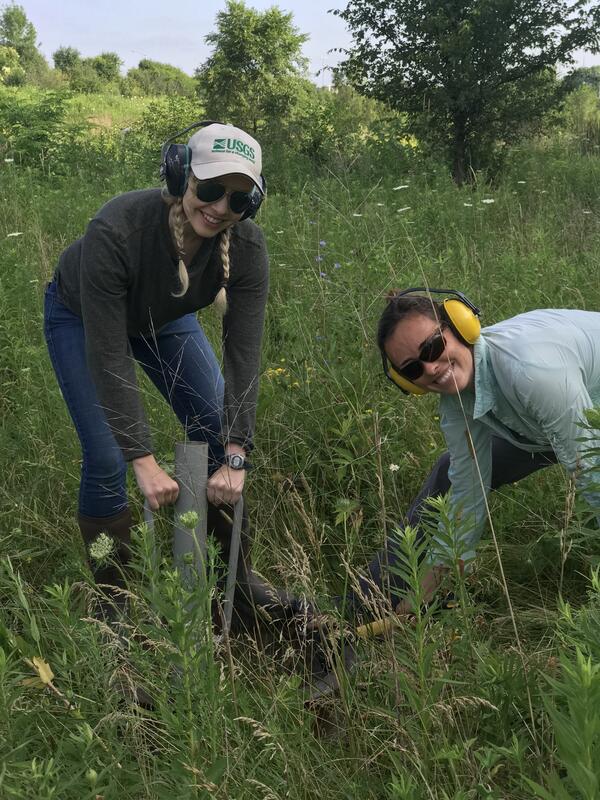
USGS scientists install a double ring infiltrometer
In this photo, USGS scientists Megan Haserodt (Hydrologist) and Jenelle Wempner (Student Intern) install a double ring infiltrometer along a recreated floodplain of Underwood Creek, a tributary to the Milwaukee River and Lake Michigan in Milwaukee, Wisconsin.
In this photo, USGS scientists Megan Haserodt (Hydrologist) and Jenelle Wempner (Student Intern) install a double ring infiltrometer along a recreated floodplain of Underwood Creek, a tributary to the Milwaukee River and Lake Michigan in Milwaukee, Wisconsin.

Grass carp larvae
These images show grass carp larvae from the Maumee River. Characteristics of larval grass carp include overall length (left), skeletal muscle development (center) and presence of an eye spot that lacks pigmentation (right; pigment starting to develop on lower eye).
These images show grass carp larvae from the Maumee River. Characteristics of larval grass carp include overall length (left), skeletal muscle development (center) and presence of an eye spot that lacks pigmentation (right; pigment starting to develop on lower eye).

Durand streamgage mounted to bridge
Durand streamgage mounted to bridge - looking downstream.
Durand streamgage mounted to bridge - looking downstream.

View from Durand bridge of boat crew conducting multibeam surveys
View from Durand bridge of boat crew conducting multibeam surveys
View from Durand bridge of boat crew conducting multibeam surveys

Hydro-tech using crane to collect a bedload sample from bridge
Hydrologic Technician using crane to collect a bedload sample from the bridge.
Hydrologic Technician using crane to collect a bedload sample from the bridge.

Illustration of subsurface-drained agricultural field
A hypothetical configuration of one of the two drained field sites, including a weather station for measuring climate data, a piezometer network for continuous water level measurements, soil moisture probes, and subsurface drainage flow. The third undrained field site will have a similar configuration, with the absence of subsurface drainage flow.
A hypothetical configuration of one of the two drained field sites, including a weather station for measuring climate data, a piezometer network for continuous water level measurements, soil moisture probes, and subsurface drainage flow. The third undrained field site will have a similar configuration, with the absence of subsurface drainage flow.
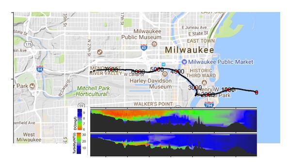
Map dissolved oxygen and turbidity Milwaukee River
Map of dissolved oxygen and turbidity along the Milwaukee River.
These data are preliminary or provisional and are subject to revision. They are being provided to meet the need for timely best science.
Map of dissolved oxygen and turbidity along the Milwaukee River.
These data are preliminary or provisional and are subject to revision. They are being provided to meet the need for timely best science.

Canada geese contribute fecal contamination to waterbodies
Canada geese in large numbers can contribute fecal contamination to waterbodies.
Canada geese in large numbers can contribute fecal contamination to waterbodies.

Wetlands, Glacial Ridge National Wildlife Refuge
Ephemeral wetlands at Glacial Ridge National Wildlife Refuge
Ephemeral wetlands at Glacial Ridge National Wildlife Refuge

Sediment core sample taken at Grubers Grove Bay Wisconsin
Sediment core sample taken at Grubers Grove Bay on the Wisconsin River, Wisconsin.
Sediment core sample taken at Grubers Grove Bay on the Wisconsin River, Wisconsin.