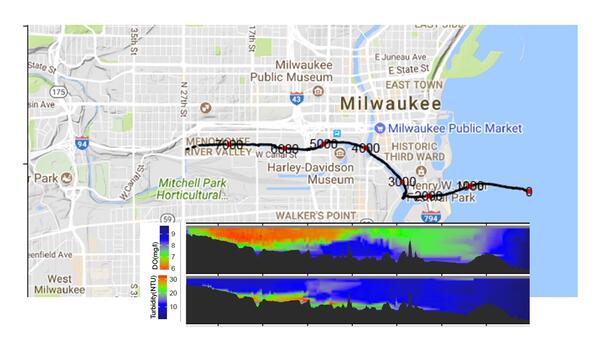
Map of dissolved oxygen and turbidity along the Milwaukee River.
These data are preliminary or provisional and are subject to revision. They are being provided to meet the need for timely best science.

Official websites use .gov
A .gov website belongs to an official government organization in the United States.
Secure .gov websites use HTTPS
A lock () or https:// means you’ve safely connected to the .gov website. Share sensitive information only on official, secure websites.
Images
Map of dissolved oxygen and turbidity along the Milwaukee River.
These data are preliminary or provisional and are subject to revision. They are being provided to meet the need for timely best science.
Map of dissolved oxygen and turbidity along the Milwaukee River.
These data are preliminary or provisional and are subject to revision. They are being provided to meet the need for timely best science.

Canada geese in large numbers can contribute fecal contamination to waterbodies.
Canada geese in large numbers can contribute fecal contamination to waterbodies.

Ephemeral wetlands at Glacial Ridge National Wildlife Refuge
Ephemeral wetlands at Glacial Ridge National Wildlife Refuge

Sediment core sample taken at Grubers Grove Bay on the Wisconsin River, Wisconsin.
Sediment core sample taken at Grubers Grove Bay on the Wisconsin River, Wisconsin.

A hypothetical configuration of one of the two drained field sites, including a weather station for measuring climate data, a piezometer network for continuous water level measurements, soil moisture probes, and subsurface drainage flow. The third undrained field site will have a similar configuration, with the absence of subsurface drainage flow.
A hypothetical configuration of one of the two drained field sites, including a weather station for measuring climate data, a piezometer network for continuous water level measurements, soil moisture probes, and subsurface drainage flow. The third undrained field site will have a similar configuration, with the absence of subsurface drainage flow.

These images show grass carp larvae from the Maumee River. Characteristics of larval grass carp include overall length (left), skeletal muscle development (center) and presence of an eye spot that lacks pigmentation (right; pigment starting to develop on lower eye).
These images show grass carp larvae from the Maumee River. Characteristics of larval grass carp include overall length (left), skeletal muscle development (center) and presence of an eye spot that lacks pigmentation (right; pigment starting to develop on lower eye).

Photograph showing the White River downstream from the White River Trail bridge, looking east toward White River State Park in downtown Indianapolis, Indiana. Photograph by Matt Williams, The Nature Conservancy.
Photograph showing the White River downstream from the White River Trail bridge, looking east toward White River State Park in downtown Indianapolis, Indiana. Photograph by Matt Williams, The Nature Conservancy.

One wild turkey in Wisconsin
One wild turkey in Wisconsin

Cross section of a fish vertebra. Useful for determining the age of a fish.
Cross section of a fish vertebra. Useful for determining the age of a fish.

A pectoral spine cross section from invasive grass carp captured in the Great Lakes. These cross sections are used to determine the age of the fish.
A pectoral spine cross section from invasive grass carp captured in the Great Lakes. These cross sections are used to determine the age of the fish.

National Geographic photographer, Keith Ladzinski, photographs live sea lamprey at Hammond Bay Biological Station on September 11, 2019 for an expansive article featuring the Great Lakes.
National Geographic photographer, Keith Ladzinski, photographs live sea lamprey at Hammond Bay Biological Station on September 11, 2019 for an expansive article featuring the Great Lakes.

GSLC research fish biologist, Dr. Ed Roseman, delivers a plenary address at the Great Lakes Areas of Concern (AOC) conference on September 11-12, 2019.
GSLC research fish biologist, Dr. Ed Roseman, delivers a plenary address at the Great Lakes Areas of Concern (AOC) conference on September 11-12, 2019.

Puffin flying at Izembek National Wildlife Refuge Alaska with Frosty Peak in background.
Puffin flying at Izembek National Wildlife Refuge Alaska with Frosty Peak in background.

Harbor seals poking their heads above water near shore in Russell Creek, Cold Bay, Alaska.
Harbor seals poking their heads above water near shore in Russell Creek, Cold Bay, Alaska.

View of the Milwaukee, Wisconsin skyline from Lake Michigan looking northwest on a late summer afternoon.
View of the Milwaukee, Wisconsin skyline from Lake Michigan looking northwest on a late summer afternoon.

View of downtown Milwaukee with single crew row boat on river.
View of downtown Milwaukee with single crew row boat on river.

View of Lake Michigan from beach.
View of Lake Michigan from beach.

Custom-designed, automated, large-volume virus water sample filtration and collection system schematic.
Custom-designed, automated, large-volume virus water sample filtration and collection system schematic.

USGS scientist extruding Lake Mendota, WI sediment while carefully removing sediment that was in contact with the polycarbonate tube to eliminate “edge effects” and smearing of upper sediment into lower portions of the core, UW-Madison Science Hall Lab.
USGS scientist extruding Lake Mendota, WI sediment while carefully removing sediment that was in contact with the polycarbonate tube to eliminate “edge effects” and smearing of upper sediment into lower portions of the core, UW-Madison Science Hall Lab.

Ohio River at Ironton, OH - tower walkway
Ohio River at Ironton, OH - tower walkway

USGS worked with regional partners to provide Ohio K-12 teachers educational resources to teach about watersheds in their classrooms.
USGS worked with regional partners to provide Ohio K-12 teachers educational resources to teach about watersheds in their classrooms.