


A postfire debris-flow deposit in Rubio Canyon, in the Eaton Fire burn area Los Angeles, County, California. Debris flows were triggered by intense rain on the recently burned hillslopes. Mud- to boulder-sized sediment was deposited by the debris flow in this image. The flow also damaged trees near and within the channel where the flow traveled.
Jason Kean
My research focuses on the processes controlling debris-flow initiation and growth, particularly after wildfire, but also in unburned areas.
This research includes a field component that obtains direct measurements of debris flows in natural settings, a modeling component that seeks to explain the observations, and an applied component that focuses on assessment of debris-flow hazards. My previous research at the USGS focused on river mechanics, including bank erosion and the development of model-based approaches to gage streams and rivers.
Science and Products
Improving Postfire Debris-Flow Hazard Assessments In The Pacific Northwest Through Application Of Debris-Flow Models
As part of the Post-fire Hazards and Impacts to Resources and Ecosystems (PHIRE): Support for Response, Recovery, and Mitigation Project, the PHIRE Debris Flow Hazard team is engaging in several studies to better understand the spatial and temporal drivers of postfire debris flows and improve postfire hazard assessments across northern California and the Pacific Northwest.
Calwood Fire "Heil Ranch" Landslide Monitoring Site near Boulder, CO
Wildfire can radically change a mountainous landscape such that even a modest rainstorm is capable of producing deadly and destructive flash flooding and debris flows.
Postfire Landslide Monitoring Station: "Chips" (2021 Dixie Fire) near Belden, CA
Wildfire can increase landslide susceptibility in mountainous terrain. The USGS maintains postfire landslide monitoring stations to track hillslope hydrologic conditions in the years following fire.
Postfire Landslide Monitoring Station: "Chambers" (2021 Dixie Fire) near Belden, CA
Wildfire can increase landslide susceptibility in mountainous terrain. The USGS maintains postfire landslide monitoring stations to track hillslope hydrologic conditions in the years following fire.
Advancing Post-Fire Debris Flow Hazard Science with a Field Deployable Mapping Tool
Mapping the occurrence of post-fire flooding and debris flow is crucial for 1) integrating observations into models used to define rainfall thresholds for early warning, 2) understanding patterns of inundation, and 3) improving models for predictive hazard assessment. Despite the critical role mapping plays in post-fire hazard assessment and early warning, there has not been a...
How Often Do Rainstorms Cause Debris Flows in Burned Areas of the Southwestern U.S.?
Debris flows, sometimes referred to as mudslides, mudflows, lahars, or debris avalanches, are common types of fast-moving landslides. They usually start on steep hillsides as a result of shallow landslides, or from runoff and erosion that liquefy and accelerate to speeds in excess of 35 mi/h. The consistency of debris flows ranges from thin, watery to thick, rocky mud that can carry large items...
Postfire debris-flow hazards
Wildfires can significantly alter the way water interacts with the landscape to the extent that even modest rainstorms can produce dangerous flash floods and debris flows. Recent fires in the western U.S. have impacted hundreds of thousands of acres of steep land, much of it public, making it susceptible to increased erosion and debris-flow activity. With the risk of severe wildfires continuing to...
2009 Station Fire, Dunsmore Canyon, Glendale, California
In 2009, the Station Fire burned 160,000 acres in the San Gabriel Mountains. Vegetation has started to return, but it can take many years for a basin to fully recover from the effects of fire.
Reconstruction of an Avalanche: The West Salt Creek Rock Avalanche
Release Date: MAY 25, 2016 The West Salt Creek Rock Avalanche, Colorado, May 25, 2014
Rainfall and Landslides in Southern California
A summary of recent and past landslides and debris flows caused by rainfall in Southern California.

Debris flow in the 2025 Eaton Fire burn area, California
A postfire debris-flow deposit in Rubio Canyon, in the Eaton Fire burn area Los Angeles, County, California. Debris flows were triggered by intense rain on the recently burned hillslopes. Mud- to boulder-sized sediment was deposited by the debris flow in this image. The flow also damaged trees near and within the channel where the flow traveled.
2020 Calwood Fire burn area, Boulder County, Colorado
Overview photograph of the area burned by the 2020 Calwood Fire in Boulder County, Colorado. The hillslopes are covered by burned tree remnants and boulders. In this view, very little vegetation has returned.
Overview photograph of the area burned by the 2020 Calwood Fire in Boulder County, Colorado. The hillslopes are covered by burned tree remnants and boulders. In this view, very little vegetation has returned.

Montecito after debris flow
The Dec. 4, 2017 Thomas fire, Southern California's largest wildfire on record, burned more than 280,000 acres across Ventura and Santa Barbara counties for nearly a month.
The Dec. 4, 2017 Thomas fire, Southern California's largest wildfire on record, burned more than 280,000 acres across Ventura and Santa Barbara counties for nearly a month.

Geologists assess scene after debris flow
Geologists assess boulders displaced during the Montecito debris flow event on Jan. 9, 2018.
Geologists assess boulders displaced during the Montecito debris flow event on Jan. 9, 2018.

Pool sign warns first responders
Swimming pool sign spray-painted to warn first responders and others to be careful around the potentially dangerous area.
Swimming pool sign spray-painted to warn first responders and others to be careful around the potentially dangerous area.

Geologists assess damage after debris-flow event
USGS geologists deployed to Santa Barbara County to support a geohazard assessment of the Montecito area
USGS geologists deployed to Santa Barbara County to support a geohazard assessment of the Montecito area
Post-Wildfire Debris Flood: 2016 Fish Fire, Van Tassel Canyon, CA
The June 2016 Fish Fire burned over 12 km^2 in Los Angeles County, California. After the fire, the USGS installed an automated rain-triggered camera and laser stage gage to monitor post-wildfire flooding and debris flow in Van Tassel Canyon near Azusa. This video shows the peak flow triggered by an intense rainstorm on January 20, 2017.
The June 2016 Fish Fire burned over 12 km^2 in Los Angeles County, California. After the fire, the USGS installed an automated rain-triggered camera and laser stage gage to monitor post-wildfire flooding and debris flow in Van Tassel Canyon near Azusa. This video shows the peak flow triggered by an intense rainstorm on January 20, 2017.

Post-wildfire debris flow: 2016 Fish Fire, Las Lomas Canyon
The June 2016 Fish Fire burned over 12 km^2 in Los Angeles County, California. After the fire, the USGS installed an automated rain-triggered camera to monitor post-wildfire flooding and debris flow in a small canyon above the Las Lomas debris basin in Duarte. This video shows the peak flow triggered by an intense rainstorm on January 20, 2017.
The June 2016 Fish Fire burned over 12 km^2 in Los Angeles County, California. After the fire, the USGS installed an automated rain-triggered camera to monitor post-wildfire flooding and debris flow in a small canyon above the Las Lomas debris basin in Duarte. This video shows the peak flow triggered by an intense rainstorm on January 20, 2017.

Post-wildfire Flood and Debris Flow: 2014 Silverado Fire
In 2014, the Silverado Fire burned approximately 4 km^2 in Orange County, California. After the fire, the USGS installed an automated rain-triggered camera to monitor post-wildfire flooding and debris flow at the outlet of a small 0.6 km^2 basin within the burn area.
In 2014, the Silverado Fire burned approximately 4 km^2 in Orange County, California. After the fire, the USGS installed an automated rain-triggered camera to monitor post-wildfire flooding and debris flow at the outlet of a small 0.6 km^2 basin within the burn area.
")
Debris Flow Monitoring at Chalk Cliffs, CO (2014)
The USGS and its cooperators have installed debris-flow monitoring equipment in the largest drainage basin at Chalk Cliffs, CO. Data collection at this site supports research on the hydrologic factors that control debris-flow initiation, entrainment, and flow dynamics.
The USGS and its cooperators have installed debris-flow monitoring equipment in the largest drainage basin at Chalk Cliffs, CO. Data collection at this site supports research on the hydrologic factors that control debris-flow initiation, entrainment, and flow dynamics.

Filled debris basin, Los Angeles County, California
Gould debris basin at a watershed outlet in Los Angeles County, California that has been filled with mud and debris. This photo was taken in 2010 after a major debris flow in the 2009 Station Fire burn area. The metal tower in the foreground is approximately 10 meters high.
Gould debris basin at a watershed outlet in Los Angeles County, California that has been filled with mud and debris. This photo was taken in 2010 after a major debris flow in the 2009 Station Fire burn area. The metal tower in the foreground is approximately 10 meters high.

Debris basin, Los Angeles County, California
An unfilled debris basin at the outlet of Gould Canyon in Los Angeles County, California. The metal tower in the foreground is approximately 10 meters high.
An unfilled debris basin at the outlet of Gould Canyon in Los Angeles County, California. The metal tower in the foreground is approximately 10 meters high.

Steep, burned hillslope in the 2009 Station Fire.
A USGS walks on a very steep, burned hillslope in the 2009 Station Fire, Angeles National Forest, California. The wildfire has removed nearly all of the vegetation from the hillslope and well-developed rills cover the ground's surface. Rills are small channels cut into the hillside by erosion processes.
A USGS walks on a very steep, burned hillslope in the 2009 Station Fire, Angeles National Forest, California. The wildfire has removed nearly all of the vegetation from the hillslope and well-developed rills cover the ground's surface. Rills are small channels cut into the hillside by erosion processes.

A USGS postfire monitoring station in the 2009 Station Fire burn area
A USGS monitoring station in the 2009 Station Fire. The Station Fire burned approximately 160,000 acres from August to October 2009, including steep terrain in the Angeles National Forest. The USGS installed this monitoring station approximately 1 month after the fire was contained to collect information about rainfall and postfire soil properties.
A USGS monitoring station in the 2009 Station Fire. The Station Fire burned approximately 160,000 acres from August to October 2009, including steep terrain in the Angeles National Forest. The USGS installed this monitoring station approximately 1 month after the fire was contained to collect information about rainfall and postfire soil properties.

Steep, burned hillslope in the 2009 Station Fire.
Well-developed rills in the 2009 Station Fire. Rills are small channels cut into the hillside by erosion processes. They have the potential to generate a large amount of sediment, which may contribute to debris-flow formation.
Well-developed rills in the 2009 Station Fire. Rills are small channels cut into the hillside by erosion processes. They have the potential to generate a large amount of sediment, which may contribute to debris-flow formation.

A USGS postfire monitoring station in the 2009 Station Fire burn area
A USGS monitoring station in the 2009 Station Fire. The Station Fire burned approximately 160,000 acres from August to October 2009, including steep terrain in the Angeles National Forest. The USGS installed this monitoring station approximately 1 month after the fire was contained to collect information about rainfall and postfire soil properties.
A USGS monitoring station in the 2009 Station Fire. The Station Fire burned approximately 160,000 acres from August to October 2009, including steep terrain in the Angeles National Forest. The USGS installed this monitoring station approximately 1 month after the fire was contained to collect information about rainfall and postfire soil properties.

USGS gage 08278500 Rio Grande at Embudo, New Mexico.
Science and Products
Improving Postfire Debris-Flow Hazard Assessments In The Pacific Northwest Through Application Of Debris-Flow Models
As part of the Post-fire Hazards and Impacts to Resources and Ecosystems (PHIRE): Support for Response, Recovery, and Mitigation Project, the PHIRE Debris Flow Hazard team is engaging in several studies to better understand the spatial and temporal drivers of postfire debris flows and improve postfire hazard assessments across northern California and the Pacific Northwest.
Calwood Fire "Heil Ranch" Landslide Monitoring Site near Boulder, CO
Wildfire can radically change a mountainous landscape such that even a modest rainstorm is capable of producing deadly and destructive flash flooding and debris flows.
Postfire Landslide Monitoring Station: "Chips" (2021 Dixie Fire) near Belden, CA
Wildfire can increase landslide susceptibility in mountainous terrain. The USGS maintains postfire landslide monitoring stations to track hillslope hydrologic conditions in the years following fire.
Postfire Landslide Monitoring Station: "Chambers" (2021 Dixie Fire) near Belden, CA
Wildfire can increase landslide susceptibility in mountainous terrain. The USGS maintains postfire landslide monitoring stations to track hillslope hydrologic conditions in the years following fire.
Advancing Post-Fire Debris Flow Hazard Science with a Field Deployable Mapping Tool
Mapping the occurrence of post-fire flooding and debris flow is crucial for 1) integrating observations into models used to define rainfall thresholds for early warning, 2) understanding patterns of inundation, and 3) improving models for predictive hazard assessment. Despite the critical role mapping plays in post-fire hazard assessment and early warning, there has not been a...
How Often Do Rainstorms Cause Debris Flows in Burned Areas of the Southwestern U.S.?
Debris flows, sometimes referred to as mudslides, mudflows, lahars, or debris avalanches, are common types of fast-moving landslides. They usually start on steep hillsides as a result of shallow landslides, or from runoff and erosion that liquefy and accelerate to speeds in excess of 35 mi/h. The consistency of debris flows ranges from thin, watery to thick, rocky mud that can carry large items...
Postfire debris-flow hazards
Wildfires can significantly alter the way water interacts with the landscape to the extent that even modest rainstorms can produce dangerous flash floods and debris flows. Recent fires in the western U.S. have impacted hundreds of thousands of acres of steep land, much of it public, making it susceptible to increased erosion and debris-flow activity. With the risk of severe wildfires continuing to...
2009 Station Fire, Dunsmore Canyon, Glendale, California
In 2009, the Station Fire burned 160,000 acres in the San Gabriel Mountains. Vegetation has started to return, but it can take many years for a basin to fully recover from the effects of fire.
Reconstruction of an Avalanche: The West Salt Creek Rock Avalanche
Release Date: MAY 25, 2016 The West Salt Creek Rock Avalanche, Colorado, May 25, 2014
Rainfall and Landslides in Southern California
A summary of recent and past landslides and debris flows caused by rainfall in Southern California.
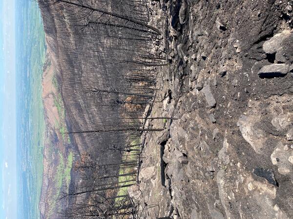
Debris flow in the 2025 Eaton Fire burn area, California
A postfire debris-flow deposit in Rubio Canyon, in the Eaton Fire burn area Los Angeles, County, California. Debris flows were triggered by intense rain on the recently burned hillslopes. Mud- to boulder-sized sediment was deposited by the debris flow in this image. The flow also damaged trees near and within the channel where the flow traveled.
A postfire debris-flow deposit in Rubio Canyon, in the Eaton Fire burn area Los Angeles, County, California. Debris flows were triggered by intense rain on the recently burned hillslopes. Mud- to boulder-sized sediment was deposited by the debris flow in this image. The flow also damaged trees near and within the channel where the flow traveled.
2020 Calwood Fire burn area, Boulder County, Colorado
Overview photograph of the area burned by the 2020 Calwood Fire in Boulder County, Colorado. The hillslopes are covered by burned tree remnants and boulders. In this view, very little vegetation has returned.
Overview photograph of the area burned by the 2020 Calwood Fire in Boulder County, Colorado. The hillslopes are covered by burned tree remnants and boulders. In this view, very little vegetation has returned.
Montecito after debris flow
The Dec. 4, 2017 Thomas fire, Southern California's largest wildfire on record, burned more than 280,000 acres across Ventura and Santa Barbara counties for nearly a month.
The Dec. 4, 2017 Thomas fire, Southern California's largest wildfire on record, burned more than 280,000 acres across Ventura and Santa Barbara counties for nearly a month.
Geologists assess scene after debris flow
Geologists assess boulders displaced during the Montecito debris flow event on Jan. 9, 2018.
Geologists assess boulders displaced during the Montecito debris flow event on Jan. 9, 2018.
Pool sign warns first responders
Swimming pool sign spray-painted to warn first responders and others to be careful around the potentially dangerous area.
Swimming pool sign spray-painted to warn first responders and others to be careful around the potentially dangerous area.
Geologists assess damage after debris-flow event
USGS geologists deployed to Santa Barbara County to support a geohazard assessment of the Montecito area
USGS geologists deployed to Santa Barbara County to support a geohazard assessment of the Montecito area
Post-Wildfire Debris Flood: 2016 Fish Fire, Van Tassel Canyon, CA
The June 2016 Fish Fire burned over 12 km^2 in Los Angeles County, California. After the fire, the USGS installed an automated rain-triggered camera and laser stage gage to monitor post-wildfire flooding and debris flow in Van Tassel Canyon near Azusa. This video shows the peak flow triggered by an intense rainstorm on January 20, 2017.
The June 2016 Fish Fire burned over 12 km^2 in Los Angeles County, California. After the fire, the USGS installed an automated rain-triggered camera and laser stage gage to monitor post-wildfire flooding and debris flow in Van Tassel Canyon near Azusa. This video shows the peak flow triggered by an intense rainstorm on January 20, 2017.
Post-wildfire debris flow: 2016 Fish Fire, Las Lomas Canyon
The June 2016 Fish Fire burned over 12 km^2 in Los Angeles County, California. After the fire, the USGS installed an automated rain-triggered camera to monitor post-wildfire flooding and debris flow in a small canyon above the Las Lomas debris basin in Duarte. This video shows the peak flow triggered by an intense rainstorm on January 20, 2017.
The June 2016 Fish Fire burned over 12 km^2 in Los Angeles County, California. After the fire, the USGS installed an automated rain-triggered camera to monitor post-wildfire flooding and debris flow in a small canyon above the Las Lomas debris basin in Duarte. This video shows the peak flow triggered by an intense rainstorm on January 20, 2017.
Post-wildfire Flood and Debris Flow: 2014 Silverado Fire
In 2014, the Silverado Fire burned approximately 4 km^2 in Orange County, California. After the fire, the USGS installed an automated rain-triggered camera to monitor post-wildfire flooding and debris flow at the outlet of a small 0.6 km^2 basin within the burn area.
In 2014, the Silverado Fire burned approximately 4 km^2 in Orange County, California. After the fire, the USGS installed an automated rain-triggered camera to monitor post-wildfire flooding and debris flow at the outlet of a small 0.6 km^2 basin within the burn area.
Debris Flow Monitoring at Chalk Cliffs, CO (2014)
The USGS and its cooperators have installed debris-flow monitoring equipment in the largest drainage basin at Chalk Cliffs, CO. Data collection at this site supports research on the hydrologic factors that control debris-flow initiation, entrainment, and flow dynamics.
The USGS and its cooperators have installed debris-flow monitoring equipment in the largest drainage basin at Chalk Cliffs, CO. Data collection at this site supports research on the hydrologic factors that control debris-flow initiation, entrainment, and flow dynamics.
Filled debris basin, Los Angeles County, California
Gould debris basin at a watershed outlet in Los Angeles County, California that has been filled with mud and debris. This photo was taken in 2010 after a major debris flow in the 2009 Station Fire burn area. The metal tower in the foreground is approximately 10 meters high.
Gould debris basin at a watershed outlet in Los Angeles County, California that has been filled with mud and debris. This photo was taken in 2010 after a major debris flow in the 2009 Station Fire burn area. The metal tower in the foreground is approximately 10 meters high.
Debris basin, Los Angeles County, California
An unfilled debris basin at the outlet of Gould Canyon in Los Angeles County, California. The metal tower in the foreground is approximately 10 meters high.
An unfilled debris basin at the outlet of Gould Canyon in Los Angeles County, California. The metal tower in the foreground is approximately 10 meters high.
Steep, burned hillslope in the 2009 Station Fire.
A USGS walks on a very steep, burned hillslope in the 2009 Station Fire, Angeles National Forest, California. The wildfire has removed nearly all of the vegetation from the hillslope and well-developed rills cover the ground's surface. Rills are small channels cut into the hillside by erosion processes.
A USGS walks on a very steep, burned hillslope in the 2009 Station Fire, Angeles National Forest, California. The wildfire has removed nearly all of the vegetation from the hillslope and well-developed rills cover the ground's surface. Rills are small channels cut into the hillside by erosion processes.
A USGS postfire monitoring station in the 2009 Station Fire burn area
A USGS monitoring station in the 2009 Station Fire. The Station Fire burned approximately 160,000 acres from August to October 2009, including steep terrain in the Angeles National Forest. The USGS installed this monitoring station approximately 1 month after the fire was contained to collect information about rainfall and postfire soil properties.
A USGS monitoring station in the 2009 Station Fire. The Station Fire burned approximately 160,000 acres from August to October 2009, including steep terrain in the Angeles National Forest. The USGS installed this monitoring station approximately 1 month after the fire was contained to collect information about rainfall and postfire soil properties.
Steep, burned hillslope in the 2009 Station Fire.
Well-developed rills in the 2009 Station Fire. Rills are small channels cut into the hillside by erosion processes. They have the potential to generate a large amount of sediment, which may contribute to debris-flow formation.
Well-developed rills in the 2009 Station Fire. Rills are small channels cut into the hillside by erosion processes. They have the potential to generate a large amount of sediment, which may contribute to debris-flow formation.
A USGS postfire monitoring station in the 2009 Station Fire burn area
A USGS monitoring station in the 2009 Station Fire. The Station Fire burned approximately 160,000 acres from August to October 2009, including steep terrain in the Angeles National Forest. The USGS installed this monitoring station approximately 1 month after the fire was contained to collect information about rainfall and postfire soil properties.
A USGS monitoring station in the 2009 Station Fire. The Station Fire burned approximately 160,000 acres from August to October 2009, including steep terrain in the Angeles National Forest. The USGS installed this monitoring station approximately 1 month after the fire was contained to collect information about rainfall and postfire soil properties.
USGS gage 08278500 Rio Grande at Embudo, New Mexico.