
A map showing North America's tropical-to-temperate transition zone. Red, orange, and yellow depict the more tropical zones, and blues depict the more temperate zones, based on to the coldest recorded temperature for each area between 1980 and 2009.
Images
Images from Region 6.
Filter Total Items: 241
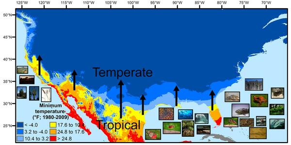
U.S. regions in the tropical-to-temperate transition
A map showing North America's tropical-to-temperate transition zone. Red, orange, and yellow depict the more tropical zones, and blues depict the more temperate zones, based on to the coldest recorded temperature for each area between 1980 and 2009.
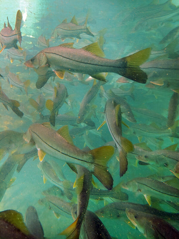
Subtropical snook gather at a warm Florida springhead in winter
Winter temperature extremes control the distributions of subtropical fishes. Common snook (Centropomus undecimalis), aggregate at a spring in northern Florida during winter. Snook are warm saltwater game fish, common in Florida, that have been moving further northward as extreme cold spells become less frequent and less intense.
Winter temperature extremes control the distributions of subtropical fishes. Common snook (Centropomus undecimalis), aggregate at a spring in northern Florida during winter. Snook are warm saltwater game fish, common in Florida, that have been moving further northward as extreme cold spells become less frequent and less intense.
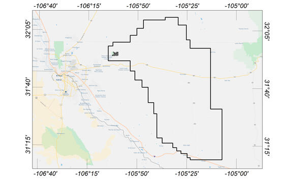
Flight area for Trans-Pecos aeromagnetic and radiometric survey
Map indicating flight area for Trans-Pecos aeromagnetic and radiometric survey. The survey area includes parts of El Paso and Hudspeth counties, Texas, and Otero County, New Mexico. Flights will begin in November 2020 and are expected to conclude in mid-January 2021.
Map indicating flight area for Trans-Pecos aeromagnetic and radiometric survey. The survey area includes parts of El Paso and Hudspeth counties, Texas, and Otero County, New Mexico. Flights will begin in November 2020 and are expected to conclude in mid-January 2021.

Austin Chalk Core
Bedding features in the core from the USGS Gulf Coast #4 Bonham borehole, in the Eagle Ford Group mudstones from a depth of about 401 feet, Fannin County, Texas. The Eagle Ford Group lies underneath the Austin Chalk and serves as the source rock for much of the Austin Chalk's petroleum.
Bedding features in the core from the USGS Gulf Coast #4 Bonham borehole, in the Eagle Ford Group mudstones from a depth of about 401 feet, Fannin County, Texas. The Eagle Ford Group lies underneath the Austin Chalk and serves as the source rock for much of the Austin Chalk's petroleum.

USGS Technicians Prepare to Take a Core of the Austin Chalk in Texas
USGS technicians at the USGS Gulf Coast #4 Bonham borehole in preparation for geophysical logging of the Austin Chalk Group and the Eagle Ford Group mudstones, Fannin County, Texas.
USGS technicians at the USGS Gulf Coast #4 Bonham borehole in preparation for geophysical logging of the Austin Chalk Group and the Eagle Ford Group mudstones, Fannin County, Texas.

Dragonfly Mercury Project specimen collection in Glacier NP
Researchers instruct volunteers on how to collect dragonfly larvae in Glacier NP as a part of the Dragonfly Mercury Project.
Researchers instruct volunteers on how to collect dragonfly larvae in Glacier NP as a part of the Dragonfly Mercury Project.

Oil, gas, and water separation vessels
Oil, gas, and water separation vessels at a carbon dioxide enhanced oil recovery operation, Horseshoe Atoll, Upper Pennsylvanian Wolfcampian play in the Permian Basin Province in Texas.
Oil, gas, and water separation vessels at a carbon dioxide enhanced oil recovery operation, Horseshoe Atoll, Upper Pennsylvanian Wolfcampian play in the Permian Basin Province in Texas.
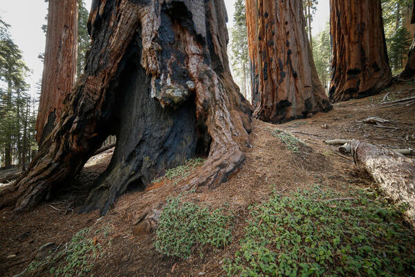
Burned, hollowed out base of a sequoia tree in Sequoia National Park
Burned, hollowed out base of a sequoia tree in Sequoia National Park
Burned, hollowed out base of a sequoia tree in Sequoia National Park

End of a long day collecting flood data on the Llano River
USGS scientists Scrott Grzyb and Michael Scheider pause at sunset at the end of a long day collecting high-water measurements along the Llano River on October 8, 2018.
USGS scientists Scrott Grzyb and Michael Scheider pause at sunset at the end of a long day collecting high-water measurements along the Llano River on October 8, 2018.

Collecting flood data on the Llano River in response to a flash flood
USGS scientist Scott Grzyb reviews high-water data collected by boat on the Llano River in Llano, Texas in response to a flash flood on October 8, 2018.
USGS scientist Scott Grzyb reviews high-water data collected by boat on the Llano River in Llano, Texas in response to a flash flood on October 8, 2018.

Vista of Buda, Eagle Ford, and Austin Formations, Terrell County
One charge of the U.S. Geological Survey’s Energy Resources Science Center is conducting field work to
better understand the distribution of hydrocarbon source rocks as input to USGS oil and gas
assessments. This 2015 image is a view to the south-southeast of rocks exposed along an unnamed
One charge of the U.S. Geological Survey’s Energy Resources Science Center is conducting field work to
better understand the distribution of hydrocarbon source rocks as input to USGS oil and gas
assessments. This 2015 image is a view to the south-southeast of rocks exposed along an unnamed

Going for the Eagle Ford Shale Formation, Kinney County, Texas
One charge of the U.S. Geological Survey’s Energy Resources Science Center is performing description
and analysis of hydrocarbon source rocks as input to USGS oil and gas assessments. This 2018 image
shows a coring and geophysical well-logging operation adjacent to U.S. Route 90, Kinney County, Texas.

Illinois River Floatcam
Rafters enjoy the floating down the Illinois River in northeast Okalahoma.
Rafters enjoy the floating down the Illinois River in northeast Okalahoma.

Eagle Ford Test Well Drilling in Texas
USGS researchers drill a research well located on the south side of U.S. 90, 7.1 miles east of Brackettville, Texas. This core was drilled by USGS during field work for an oil and gas assessment for the Eagle Ford of the Gulf Coast Basins. Cores like these provide information on the various rock layers, such as their make-up, their age, etc.
USGS researchers drill a research well located on the south side of U.S. 90, 7.1 miles east of Brackettville, Texas. This core was drilled by USGS during field work for an oil and gas assessment for the Eagle Ford of the Gulf Coast Basins. Cores like these provide information on the various rock layers, such as their make-up, their age, etc.

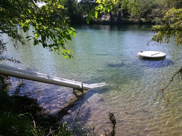
Swimming hole on Cypress Creek in Blue Hole Regional Park, Wimberley
Photograph showing swimming hole on Cypress Creek in Blue Hole Regional Park, Wimberley, Hays County, Texas (photograph by Allan K. Clark, U.S. Geological Survey, February 27, 2018).
U.S. Geological Survey Scientific Investigations Map 3418, https://doi.org/10.3133/sim3418.
Photograph showing swimming hole on Cypress Creek in Blue Hole Regional Park, Wimberley, Hays County, Texas (photograph by Allan K. Clark, U.S. Geological Survey, February 27, 2018).
U.S. Geological Survey Scientific Investigations Map 3418, https://doi.org/10.3133/sim3418.

Blanco River Valley
Photograph showing the Blanco River Valley, looking north from Little Arkansas Road, Hays County, Texas (photograph by Allan K. Clark, U.S. Geological Survey, February 27, 2018).
U.S. Geological Survey Scientific Investigations Map 3418, https://doi.org/10.3133/sim3418.
Photograph showing the Blanco River Valley, looking north from Little Arkansas Road, Hays County, Texas (photograph by Allan K. Clark, U.S. Geological Survey, February 27, 2018).
U.S. Geological Survey Scientific Investigations Map 3418, https://doi.org/10.3133/sim3418.

Low water crossing on the Blanco River, Hays County, Texas
Photograph showing a low water crossing on the Blanco River, looking south from Little Arkansas Road, Hays County, Texas (photograph by Allan K. Clark, U.S. Geological Survey, February 27, 2018).
U.S. Geological Survey Scientific Investigations Map 3418, https://doi.org/10.3133/sim3418.
Photograph showing a low water crossing on the Blanco River, looking south from Little Arkansas Road, Hays County, Texas (photograph by Allan K. Clark, U.S. Geological Survey, February 27, 2018).
U.S. Geological Survey Scientific Investigations Map 3418, https://doi.org/10.3133/sim3418.

Conglomerates, Sycamore Sand at Hammetts Crossing, Travis Cty, Texas
Conglomerates within the Sycamore Sand at Hammetts Crossing, Travis County, Texas (photograph by Allan K. Clark, U.S. Geological Survey, February 27, 2018).
U.S. Geological Survey Scientific Investigations Map 3418, https://doi.org/10.3133/sim3418
Conglomerates within the Sycamore Sand at Hammetts Crossing, Travis County, Texas (photograph by Allan K. Clark, U.S. Geological Survey, February 27, 2018).
U.S. Geological Survey Scientific Investigations Map 3418, https://doi.org/10.3133/sim3418

Bedding plane porosity in fracture at Cow Creek Limestone
Bedding plane porosity that developed at the junction between the bedding plane and a fracture within the Cow Creek Limestone (Cow Creek hydrostratigraphic unit) at Hammetts Crossing, Travis County, Texas (photograph by Allan K. Clark, U.S. Geological Survey, February 27, 2018).
Bedding plane porosity that developed at the junction between the bedding plane and a fracture within the Cow Creek Limestone (Cow Creek hydrostratigraphic unit) at Hammetts Crossing, Travis County, Texas (photograph by Allan K. Clark, U.S. Geological Survey, February 27, 2018).

Jacobs Well Spring, headwaters of Cypress Creek, Wimberley, Tex.
Jacobs Well Spring, which forms the headwaters of Cypress Creek north of Wimberley, Texas (photograph by Allan K. Clark,
U.S. Geological Survey, February 27, 2018).
U.S. Geological Survey Scientific Investigations Map 3418, https://doi.org/10.3133/sim3418
Jacobs Well Spring, which forms the headwaters of Cypress Creek north of Wimberley, Texas (photograph by Allan K. Clark,
U.S. Geological Survey, February 27, 2018).
U.S. Geological Survey Scientific Investigations Map 3418, https://doi.org/10.3133/sim3418
Monitoring equipment at Frio River at Concan, Tex.
Monitoring equipment at Frio River at Concan, Tex.
Monitoring equipment at Frio River at Concan, Tex.