
Map of historic and current sage-grouse range in 2000, provided as a download from the old USGS Sagemap website.
Images
Explore images.
Filter Total Items: 701

map of historic and current sage-grouse range in 2000
Map of historic and current sage-grouse range in 2000, provided as a download from the old USGS Sagemap website.

Turbid Coastal Plume of the Elwha River, Washington
The turbid waters of the Elwha River and the coastal waters of the Strait of Juan de Fuca mix directly offshore of the river mouth, forming a large coastal plume. This plume is easily identified by the cloudiness of the water (or "turbidity") resulting from sediment discharged by the river. Two large dams on the Elwha River were incrementally r
The turbid waters of the Elwha River and the coastal waters of the Strait of Juan de Fuca mix directly offshore of the river mouth, forming a large coastal plume. This plume is easily identified by the cloudiness of the water (or "turbidity") resulting from sediment discharged by the river. Two large dams on the Elwha River were incrementally r

Turbid Coastal Plume of the Elwha River, Washington
The turbid waters of the Elwha River and the coastal waters of the Strait of Juan de Fuca mix directly offshore of the river mouth, forming a large coastal plume. This plume is easily identified by the cloudiness of the water (or "turbidity") resulting from sediment discharged by the river. Two large dams on the Elwha River are being incrementally r
The turbid waters of the Elwha River and the coastal waters of the Strait of Juan de Fuca mix directly offshore of the river mouth, forming a large coastal plume. This plume is easily identified by the cloudiness of the water (or "turbidity") resulting from sediment discharged by the river. Two large dams on the Elwha River are being incrementally r

Retrieving Sediment Instrumentation, Elwha River, Washington
USGS researchers Chris Curran and Raegan Huffman retrieve instrumentation to measure sediment concentration from the Elwha River, Washington. Two large dams on the Elwha River are being incrementally removed from 2011 to 2013 to restore river function in an important salmon-bearing river.
USGS researchers Chris Curran and Raegan Huffman retrieve instrumentation to measure sediment concentration from the Elwha River, Washington. Two large dams on the Elwha River are being incrementally removed from 2011 to 2013 to restore river function in an important salmon-bearing river.

Rime ice coats telemetry station north of Mount St. Helens, WA
Volcano monitoring stations must be designed to withstand harsh winter conditions.
Volcano monitoring stations must be designed to withstand harsh winter conditions.

Revegetation planting day at former Lake Mills
Revegetation planting day at former Lake Mills reservoir as Glines Canyon Dam is removed. Image available at Olympic National Park flickr site.
Revegetation planting day at former Lake Mills reservoir as Glines Canyon Dam is removed. Image available at Olympic National Park flickr site.
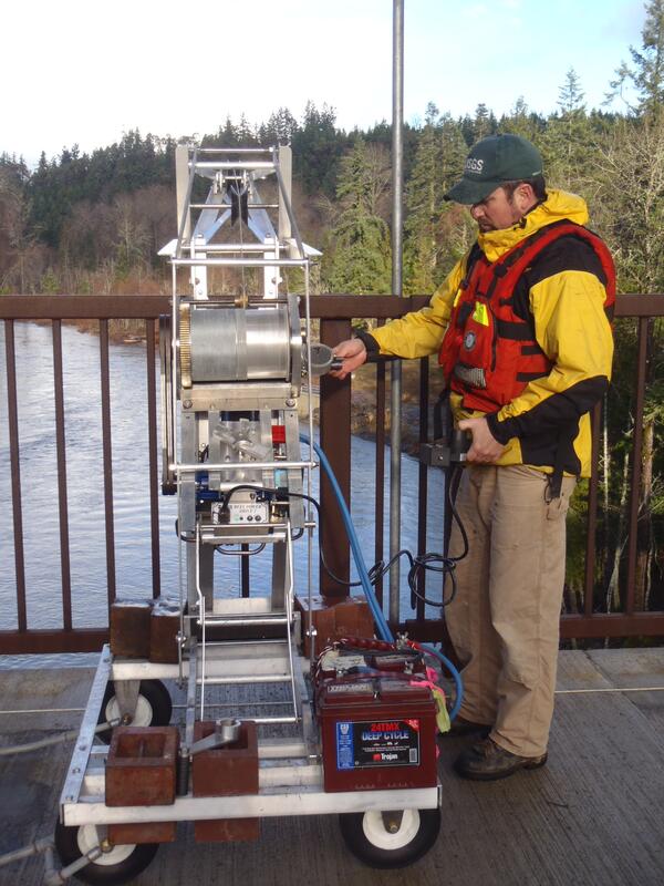
Operating Sediment-sampling Reel, Elwha River, Washington
USGS hydrologic technician James Foreman operates an electronic deployment reel from a bridge over the Elwha River, Washington. Two large dams on the Elwha River are being incrementally removed from 2011 to 2013 to restore river function in an important salmon-bearing river.
USGS hydrologic technician James Foreman operates an electronic deployment reel from a bridge over the Elwha River, Washington. Two large dams on the Elwha River are being incrementally removed from 2011 to 2013 to restore river function in an important salmon-bearing river.

Surveying channel change in Fanno Creek, OR
USGS hydrologist surveying channel depth across Fanno Creek, OR
USGS hydrologist surveying channel depth across Fanno Creek, OR

Mount Adams, WA
A photograph of Mount Adams, Washington. This image was taken as part of the Land Cover Trends Project field varification for land cover data.
A photograph of Mount Adams, Washington. This image was taken as part of the Land Cover Trends Project field varification for land cover data.

Extent of Newberry lavas including approximate ages of surficial flows
Extending approximately 75 miles north to south and 27 miles east to west, Newberry Volcano and its broad apron of lavas (light yellow shaded area) cover a total area of almost 1,200 square miles, making it the largest volcano of the Cascades volcanic chain. Its lavas stretch north beyond Smith Rock State Park, and south almost to Fort Rock State Natural Area.
Extending approximately 75 miles north to south and 27 miles east to west, Newberry Volcano and its broad apron of lavas (light yellow shaded area) cover a total area of almost 1,200 square miles, making it the largest volcano of the Cascades volcanic chain. Its lavas stretch north beyond Smith Rock State Park, and south almost to Fort Rock State Natural Area.

Experiments on sagebrush in a common garden
Two USGS scientists set up equipment to measure sagebrush in a common garden experiment in the Great Basin, Idaho
Two USGS scientists set up equipment to measure sagebrush in a common garden experiment in the Great Basin, Idaho

Kootenai River Habitat Restoration
Constructed channel features and changes in the Phase 1A side channel restoration area of the Kootenai River near Bonners Ferry, Idaho. The Kootenai Tribe of Idaho is managing a large-scale, ecosystem-based river habitat restoration effort that will be implemented over a period of 10 to 15 years across a 55-mile reach of the Kootenai River in northern Idaho.
Constructed channel features and changes in the Phase 1A side channel restoration area of the Kootenai River near Bonners Ferry, Idaho. The Kootenai Tribe of Idaho is managing a large-scale, ecosystem-based river habitat restoration effort that will be implemented over a period of 10 to 15 years across a 55-mile reach of the Kootenai River in northern Idaho.

Blackfoot River, Southeastern Idaho
Sceintists from the U.S. Geological Survey and the Idaho Department of Environmental Quality combined and analyzed data from two separate water-quality monitoring efforts in the upper Blackfoot River of southeastern Idaho.
Sceintists from the U.S. Geological Survey and the Idaho Department of Environmental Quality combined and analyzed data from two separate water-quality monitoring efforts in the upper Blackfoot River of southeastern Idaho.

Panther Creek Upstream of Big Deer Creek, central Idaho
Panther Creek was severely damaged by heavy metals released from mining and milling activities at the former Blackbird Mine. USGS and other scientists compiled a 30-year record of recovery of the stream’s fish and macroinvertebrate populations.
Panther Creek was severely damaged by heavy metals released from mining and milling activities at the former Blackbird Mine. USGS and other scientists compiled a 30-year record of recovery of the stream’s fish and macroinvertebrate populations.

Measuring the light in Minam River, OR
USGS scientist meaures how much light is transmitted into the Wallowa River, near Minam, OR.
USGS scientist meaures how much light is transmitted into the Wallowa River, near Minam, OR.

Stream channel cross-section measurements—instrument that uses lase...
Stream channel cross-section measurements—instrument that uses laser pulses to survey distance to a reflector operated by a second crew member, Mount St. Helens.
Stream channel cross-section measurements—instrument that uses laser pulses to survey distance to a reflector operated by a second crew member, Mount St. Helens.
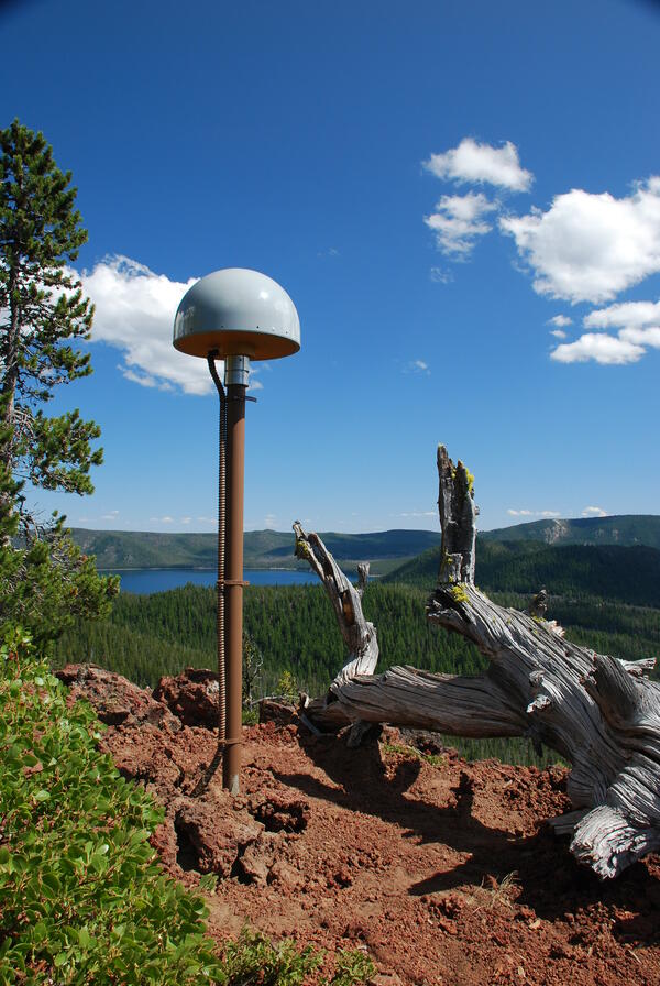
Global Positioning System receiver (called a GPS monument) at North...
Global Positioning System receiver (called a GPS monument) at North Rim Station, a monitoring location at Newberry volcano, Oregon.
Global Positioning System receiver (called a GPS monument) at North Rim Station, a monitoring location at Newberry volcano, Oregon.

Newberry caldera with Paulina Peak, Big Obsidian Flow and Paulina Lake
View looking south across Newberry caldera towards the Big Obsidian flow (left of center) and Paulina Peak, with Paulina Lake in foreground. Photo taken from the north rim of the caldera.
View looking south across Newberry caldera towards the Big Obsidian flow (left of center) and Paulina Peak, with Paulina Lake in foreground. Photo taken from the north rim of the caldera.

Gas sampling with CO2 Infrared Spectrometer at Mount St. Helens
Gas sampling with a CO2 Infrared Spectrometer at Mount St. Helens' September Lobe lava dome, Washington.
Gas sampling with a CO2 Infrared Spectrometer at Mount St. Helens' September Lobe lava dome, Washington.

Juvenile Pacific herring with skin ulcers
Juvenile Pacific herring with skin ulcers from Ichthyophonus disease.
Juvenile Pacific herring with skin ulcers from Ichthyophonus disease.
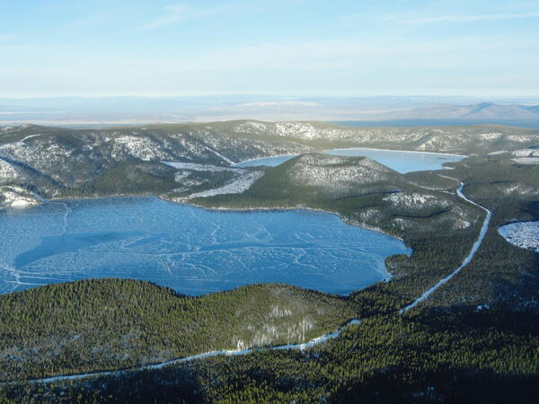
Aerial view of lakes and cinder cone at Newberry Volcano Caldera.
A view looking northeast across the central caldera of Newberry Volcano. Paulina Lake is in the foreground and East Lake is in the distance. The Central Pumice Cone lies between the two lakes. Near the bottom of the photo at the south edge of Paulina Lake, the two hills are named the Lakeshore Domes.
A view looking northeast across the central caldera of Newberry Volcano. Paulina Lake is in the foreground and East Lake is in the distance. The Central Pumice Cone lies between the two lakes. Near the bottom of the photo at the south edge of Paulina Lake, the two hills are named the Lakeshore Domes.