
Deep water camera and light installed in the head weight of the upgraded USGS jumbo piston corer. In the background, USGS Marine Engineering Technician Daniel Powers is preparing the core liner for sediment collection.
Images
Images intro.
Filter Total Items: 1192

Jumbo Piston Corer
Deep water camera and light installed in the head weight of the upgraded USGS jumbo piston corer. In the background, USGS Marine Engineering Technician Daniel Powers is preparing the core liner for sediment collection.

Jumbo Piston Corer
Pete Dal Ferro, USGS Marine Engineering Technician and lead fabricator on the JPC upgrade, monitors the testing of the coring system on R/V Hugh R. Sharp in March 2022.
Pete Dal Ferro, USGS Marine Engineering Technician and lead fabricator on the JPC upgrade, monitors the testing of the coring system on R/V Hugh R. Sharp in March 2022.

Global Marine Mineral Resources Group
Global Marine Mineral Resources Group. From left to right, USGS Research Oceanographer Amy Gartman, visiting scientist Mariana Benites from University São Paolo, USGS Physical Scientist Denise Payan, graduate student Noemi Ortega Dominguez, student contractor Manda Au, and USGS Research Oceanographer Kira Mizell.
Global Marine Mineral Resources Group. From left to right, USGS Research Oceanographer Amy Gartman, visiting scientist Mariana Benites from University São Paolo, USGS Physical Scientist Denise Payan, graduate student Noemi Ortega Dominguez, student contractor Manda Au, and USGS Research Oceanographer Kira Mizell.

Fire plus Flood equals Beach
Triptych of images showing wildfire, roadside flooding, and the Big Sur coastline in California.
Triptych of images showing wildfire, roadside flooding, and the Big Sur coastline in California.

The wee strand, Loch Indaal, Scotland
The wee strand is a beach along the head of of Loch Indaal, Scotland. Loch Indaal is an ocean bay on Islay, the southernmost island of the Hebrides, off the west coast of Scotland.
The wee strand is a beach along the head of of Loch Indaal, Scotland. Loch Indaal is an ocean bay on Islay, the southernmost island of the Hebrides, off the west coast of Scotland.

Jumbo Piston Corer
Upgraded USGS jumbo piston corer being readied for deployment off the research vessel Hugh R. Sharp in April 2022.
Upgraded USGS jumbo piston corer being readied for deployment off the research vessel Hugh R. Sharp in April 2022.

USGS ocean current drifter disk
None the worse for wear, a plastic, ocean current drifter disk, originally released off Barter Island in Alaska, was discovered on the coast of Scotland 37 years after its initial release into the ocean.
None the worse for wear, a plastic, ocean current drifter disk, originally released off Barter Island in Alaska, was discovered on the coast of Scotland 37 years after its initial release into the ocean.

USGS ocean drifter
A 37-year-old plastic ocean drifter, originally released off Barter Island in Alaska, was discovered on the coast of Scotland.
A 37-year-old plastic ocean drifter, originally released off Barter Island in Alaska, was discovered on the coast of Scotland.

PCMSC scientist measuring land-surface elevation near the bay-marsh edge of Whale's Tail South marsh
linkPCMSC scientist measuring land-surface elevation near the bay-marsh edge of Whale's Tail South marsh in Eden Landing Ecological Reserve, Hayward, CA, with birds foraging on the South San Francisco Bay mudflats at low tide in the background.

Scientists from PCMSC deploying instruments to measure water level and suspended-sediment concentration in Whale's Tail South marsh
linkScientists from PCMSC deploying instruments to measure water level and suspended-sediment concentration in Whale's Tail South marsh in Eden Landing Ecological Reserve, Hayward, CA.

Video monitoring at Nuvuk
This image from a video camera pointed at the coast tracks the brightest pixels in the camera view over 10 minutes of video. The resulting image is useful for identifying features such as the position of maximum wave run-up on the beach, the position of all breaking waves, and sea-state.
This image from a video camera pointed at the coast tracks the brightest pixels in the camera view over 10 minutes of video. The resulting image is useful for identifying features such as the position of maximum wave run-up on the beach, the position of all breaking waves, and sea-state.

Video camera snapshot at Point Barrow, AK
Two coastal observing video cameras are installed atop a utility pole near the northernmost point of land in the United States: at Nuvuk (Point Barrow), Alaska.
Two coastal observing video cameras are installed atop a utility pole near the northernmost point of land in the United States: at Nuvuk (Point Barrow), Alaska.

DUNEX Crew
A calm hazy horizon after the team pushed two boats up and over the dune to be launched from the beach on Pea Island.
This field work was conducted as part of the During Nearshore Event Experiment (DUNEX) in 2021.
A calm hazy horizon after the team pushed two boats up and over the dune to be launched from the beach on Pea Island.
This field work was conducted as part of the During Nearshore Event Experiment (DUNEX) in 2021.

Installing CoastCam at Pea Island before a storm
Assembling the CoastCam station, USGS researchers Jenna Brown and Meg Palmsten stake down support wires as a storm approaches the Pea Island field site.
This field work was conducted as part of the During Nearshore Event Experiment (DUNEX) in 2021.
Assembling the CoastCam station, USGS researchers Jenna Brown and Meg Palmsten stake down support wires as a storm approaches the Pea Island field site.
This field work was conducted as part of the During Nearshore Event Experiment (DUNEX) in 2021.

DUNEX Cross-Shore Array
Cross-shore array of poles equipped with various sensors to measure water level and other parameters at Pea Island National Wildlife Refuge. This equipment was deployed as part of the During Nearshore Event Experiment (DUNEX) in 2021.
Cross-shore array of poles equipped with various sensors to measure water level and other parameters at Pea Island National Wildlife Refuge. This equipment was deployed as part of the During Nearshore Event Experiment (DUNEX) in 2021.

Video camera setup at Point Barrow, Alaska
Point Barrow, Alaska, or Nuvuk, is the northernmost point in the United States. USGS has set up video cameras, mounted to the pole shown here, to study sediment movement and wave dynamics along this dynamic coastline.
Point Barrow, Alaska, or Nuvuk, is the northernmost point in the United States. USGS has set up video cameras, mounted to the pole shown here, to study sediment movement and wave dynamics along this dynamic coastline.

Video camera setup at Nuvuk, Alaska
Point Barrow, Alaska, or Nuvuk, is the northernmost point in the United States. USGS has set up video cameras, mounted to the pole shown here, to study sediment movement and wave dynamics along this dynamic coastline.
Point Barrow, Alaska, or Nuvuk, is the northernmost point in the United States. USGS has set up video cameras, mounted to the pole shown here, to study sediment movement and wave dynamics along this dynamic coastline.

Video camera setup, Point Barrow, Alaska
Point Barrow, Alaska, or Nuvuk, is the northernmost point in the United States. USGS has set up video cameras, mounted to the pole shown here, to study sediment movement and wave dynamics along this dynamic coastline.
Point Barrow, Alaska, or Nuvuk, is the northernmost point in the United States. USGS has set up video cameras, mounted to the pole shown here, to study sediment movement and wave dynamics along this dynamic coastline.

Hurricane Damage to Coral Reefs Increases Future Flood Risk Across Puerto Rico
This map identifies where hurricane damage to reefs has increased future annual flood risk the most per kilometer of coastline.
This map identifies where hurricane damage to reefs has increased future annual flood risk the most per kilometer of coastline.
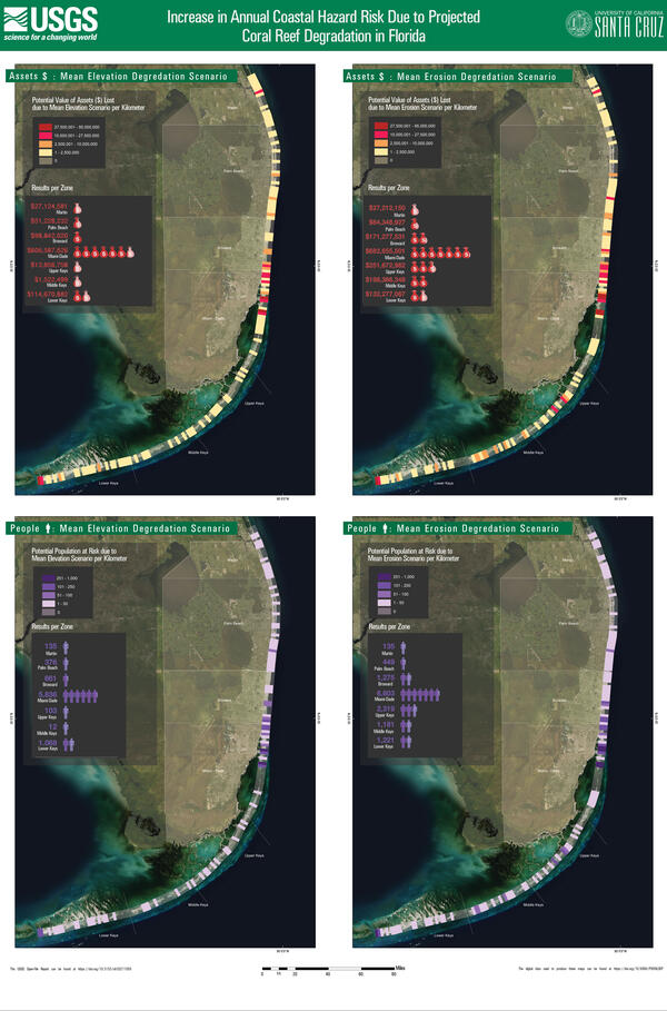
Coastal hazard risk increase due to reef degradation: Florida
Four scenarios for the southern part of the Florida coastline show the increase in annual coastal hazard risk due to projected coral reef degradation.
Four scenarios for the southern part of the Florida coastline show the increase in annual coastal hazard risk due to projected coral reef degradation.

Annual coastal hazard risk increase due to hurricanes in Florida
Maps for the southern part of the Florida coastline show the increase in annual coastal hazard risk due to damage by Hurricanes Irma and Maria.
- Increase in population at risk due to coral reef damage per kilometer (left)
- Increase in value ($) of assets at risk due to coral reef damage per kilometer (right)