
Still-image from video camera atop the Dream Inn looks eastward over Main Beach and boardwalk in Santa Cruz, CA.
Images
Images intro.
Filter Total Items: 1196

Santa Cruz Main Beach
Still-image from video camera atop the Dream Inn looks eastward over Main Beach and boardwalk in Santa Cruz, CA.

Santa Cruz Main Beach Webcam Snapshot
Snapshot from video camera that sits atop the Dream Inn looks eastward over Main Beach and boardwalk in Santa Cruz, California.
Snapshot from video camera that sits atop the Dream Inn looks eastward over Main Beach and boardwalk in Santa Cruz, California.

Mud Creek Shaded-Relief Topography, 2010-2017
A series of images from various sources of shaded-relief topography show the progression of the Mud Creek landslide area, from 2010 through October 12, 2017.
Sources:
A series of images from various sources of shaded-relief topography show the progression of the Mud Creek landslide area, from 2010 through October 12, 2017.
Sources:

Mud Creek Topo Change June 13-October 12 2017 View 3
In 2017, the massive Mud Creek landslide buried a quarter-mile of the famous coastal route, California’s Highway 1, with rocks and dirt more than 65 feet deep. USGS monitors erosion along the landslide-prone cliffs of Big Sur, collecting aerial photos frequently throughout the year.
In 2017, the massive Mud Creek landslide buried a quarter-mile of the famous coastal route, California’s Highway 1, with rocks and dirt more than 65 feet deep. USGS monitors erosion along the landslide-prone cliffs of Big Sur, collecting aerial photos frequently throughout the year.

Mud Creek Topo Change June 13-October 12 2017 View 1
In 2017, the massive Mud Creek landslide buried a quarter-mile of the famous coastal route, California’s Highway 1, with rocks and dirt more than 65 feet deep. USGS monitors erosion along the landslide-prone cliffs of Big Sur, collecting aerial photos frequently throughout the year.
In 2017, the massive Mud Creek landslide buried a quarter-mile of the famous coastal route, California’s Highway 1, with rocks and dirt more than 65 feet deep. USGS monitors erosion along the landslide-prone cliffs of Big Sur, collecting aerial photos frequently throughout the year.

Mud Creek Topo Change June 13-October 12 2017 View 2
In 2017, the massive Mud Creek landslide buried a quarter-mile of the famous coastal route, California’s Highway 1, with rocks and dirt more than 65 feet deep. USGS monitors erosion along the landslide-prone cliffs of Big Sur, collecting aerial photos frequently throughout the year.
In 2017, the massive Mud Creek landslide buried a quarter-mile of the famous coastal route, California’s Highway 1, with rocks and dirt more than 65 feet deep. USGS monitors erosion along the landslide-prone cliffs of Big Sur, collecting aerial photos frequently throughout the year.

Mud Creek – 3D Point Cloud – Oblique Perspective
Video shot from drones yields details about changing landslide on California’s Big Sur coast
Video shot from drones yields details about changing landslide on California’s Big Sur coast

Drone operations on Big Sur landslide, October 12, 2017
Josh Logan, a physical scientist at the USGS Pacific Coastal and Marine Science Center in Santa Cruz, California, operates an unmanned aerial system, or UAS, often called a "drone", that is equipped with a video camera.
Josh Logan, a physical scientist at the USGS Pacific Coastal and Marine Science Center in Santa Cruz, California, operates an unmanned aerial system, or UAS, often called a "drone", that is equipped with a video camera.

Earth movers on Big Sur landslide, October 12, 2017
View of the huge landslide at Mud Creek on the Big Sur coast, October 12, 2017. USGS is studying the landslide, collecting data and imagery that can be used to monitor changes. USGS provides the data to Caltrans, the California Department of Transportation, whose heavy equipment and earth movers are shown here.
View of the huge landslide at Mud Creek on the Big Sur coast, October 12, 2017. USGS is studying the landslide, collecting data and imagery that can be used to monitor changes. USGS provides the data to Caltrans, the California Department of Transportation, whose heavy equipment and earth movers are shown here.

Mud Creek from June 13 to October 12, 2017
In 2017, the massive Mud Creek landslide buried a quarter-mile of the famous coastal route, California’s Highway 1, with rocks and dirt more than 65 feet deep. USGS monitors erosion along the landslide-prone cliffs of Big Sur, collecting aerial photos frequently throughout the year.
In 2017, the massive Mud Creek landslide buried a quarter-mile of the famous coastal route, California’s Highway 1, with rocks and dirt more than 65 feet deep. USGS monitors erosion along the landslide-prone cliffs of Big Sur, collecting aerial photos frequently throughout the year.
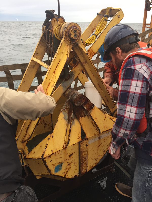
Examining bucket of seafloor sediment collected off southeast Alaska
USGS research geophysicist Danny Brothers (right) and colleagues examine the surface of a sediment grab sample just pulled onto the deck of the Canadian Coast Guard Ship John P. Tully. The sample was collected from the top of a mud volcano north of the border between southeast Alaska and British Columbia.
USGS research geophysicist Danny Brothers (right) and colleagues examine the surface of a sediment grab sample just pulled onto the deck of the Canadian Coast Guard Ship John P. Tully. The sample was collected from the top of a mud volcano north of the border between southeast Alaska and British Columbia.

Collecting a piston core of seafloor sediment off British Columbia
Scientists prepare to lower a piston corer off Haida Gwaii, British Columbia, to sample seafloor sediment near the Queen Charlotte-Fairweather fault. Expedition scientists are studying layers of sediment in the cores they collected to identify and determine ages of past earthquakes along the fault.
Scientists prepare to lower a piston corer off Haida Gwaii, British Columbia, to sample seafloor sediment near the Queen Charlotte-Fairweather fault. Expedition scientists are studying layers of sediment in the cores they collected to identify and determine ages of past earthquakes along the fault.

Sampling core fluid from sediment cores collected off southeast Alaska
Mary McGann (left, USGS) and Rachel Lauer (University of Calgary) sample pore fluids from sediment cores collected aboard the Canadian Coast Guard Ship John P. Tully along the Queen Charlotte-Fairweather fault offshore of southeast Alaska.
Mary McGann (left, USGS) and Rachel Lauer (University of Calgary) sample pore fluids from sediment cores collected aboard the Canadian Coast Guard Ship John P. Tully along the Queen Charlotte-Fairweather fault offshore of southeast Alaska.

USGS scientist Carol Reiss holding a hydrothermal vent sample
USGS scientist Carol Reiss holding a hydrothermal vent sample. The poster in the background is a scientific rendering by Véronique Robigou (then at University of Washington) of a hydrothermal vent deposit with the submersible Alvin drawn to scale.
USGS scientist Carol Reiss holding a hydrothermal vent sample. The poster in the background is a scientific rendering by Véronique Robigou (then at University of Washington) of a hydrothermal vent deposit with the submersible Alvin drawn to scale.

USGS geologist Carol Reiss examining hydrothermal vent sample
USGS geologist Carol Reiss examining hydrothermal vent sample using hand lens. Sulfide-silicate minerals precipitate from 330°C mineral laden water venting along volcanically active spreading ridges.
USGS geologist Carol Reiss examining hydrothermal vent sample using hand lens. Sulfide-silicate minerals precipitate from 330°C mineral laden water venting along volcanically active spreading ridges.

Skagit Bay bathymetry
Skagit Bay bathymetry

McKelvey Building on the Menlo Park USGS campus
Construction of the McKelvey Building, or Building 15, was completed in the mid-1990s on the USGS Western Region campus in Menlo Park, California. It houses many different USGS teams, such as Pacific Coastal and Marine Science Center, Water Science Center, and Volcano Science Center, and features many state-of-the-art laboratories.
Construction of the McKelvey Building, or Building 15, was completed in the mid-1990s on the USGS Western Region campus in Menlo Park, California. It houses many different USGS teams, such as Pacific Coastal and Marine Science Center, Water Science Center, and Volcano Science Center, and features many state-of-the-art laboratories.

Scott Creek area of California coast
Aerial photograph looking north, Scott Creek Beach in distance, along the California coast near Davenport.
Aerial photograph looking north, Scott Creek Beach in distance, along the California coast near Davenport.

X-ray diffractometer
USGS research oceanographer Amy Gartman waits for an X-ray diffractometer to analyze samples of hydrothermal sulfide minerals.
USGS research oceanographer Amy Gartman waits for an X-ray diffractometer to analyze samples of hydrothermal sulfide minerals.

Seafloor crust, Marshall Islands
Cross section of a seafloor crust (AKA, ferromanganese or cobalt-rich crusts) from the Marshall Islands collected at almost 2,000 meters depth.
Cross section of a seafloor crust (AKA, ferromanganese or cobalt-rich crusts) from the Marshall Islands collected at almost 2,000 meters depth.

San Gregorio Beach and Creek
Flow from San Gregorio Creek in San Gregorio, California is often blocked by a natural sand levee when the flow is not strong enough to push through to the Pacific Ocean.
Flow from San Gregorio Creek in San Gregorio, California is often blocked by a natural sand levee when the flow is not strong enough to push through to the Pacific Ocean.