
What and Where Are Biological Soil Crusts?
Images
Below are images associated with SBSC's science and staff. Images appear according to the year they were taken. To search, type a keyword or select a year from the dropdown menu. Or, click through the pages using the arrows at the bottom of the page.
Filter Total Items: 492

Screenshot of "Biological Soil Crusts — Webs of Life in the Desert" Fact Sheet

Fish seining efforts on the Colorado River
Fish seining efforts on the Colorado River
Fish seining efforts on the Colorado River

Hoop fishing net deployed on the Little Colorado River
Hoop fishing net deployed on the Little Colorado River just downstream of a travetine fall
Hoop fishing net deployed on the Little Colorado River just downstream of a travetine fall

Repeat photograph of the San Pedro River valley, near St. David, AZ.
Repeat photograph of the San Pedro River valley, near St. David, southern AZ. This photo was taken in 1994 by Dr. Robert Webb, USGS, as a repeat photograph of the 1981 Roskruge image and 1962 J.R. Hastings image. The image series is from the SBSC's Southwest Repeat Photography Collection, stake (camera point) s0151.
Repeat photograph of the San Pedro River valley, near St. David, southern AZ. This photo was taken in 1994 by Dr. Robert Webb, USGS, as a repeat photograph of the 1981 Roskruge image and 1962 J.R. Hastings image. The image series is from the SBSC's Southwest Repeat Photography Collection, stake (camera point) s0151.
Repeat photograph taken in 1994 along the Colorado River that is a match to an EC LaRue USGS 1923 Birdseye Expedition image
linkA USGS repeat photograph that is a match to an E.C. LaRue USGS image from 1923, taken during the Birdseye Expedition, prior to Glen Canyon Dam construction upstream of this site on the Colorado River.
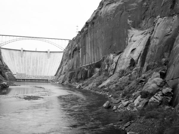
Repeat photograph taken in 1992 of Glen Canyon Dam, a match to the 1889 image by Nims from the Stanton Expedition
linkA USGS repeat photograph of Glen Canyon Dam taken on October 29, 1992 as a match to the 1889 Franklin Nims image of the site before the dam was built, at Colorado River mile -14.7, during the Stanton Expedition. The view is taken upstream from river left. Stake (camera point) s2638 in the SBSC's Southwest Repeat Photography Collection.
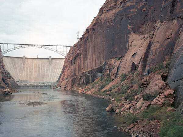
Repeat color photograph taken in 1992 of Glen Canyon Dam, a match to the 1889 image by Nims from the Stanton Expedition
linkA USGS repeat color photograph of Glen Canyon Dam taken on October 29, 1992 as a match to the 1889 Franklin Nims image of the site before the dam was built, at Colorado River mile -14.7, during the Stanton Expedition. The view is taken upstream from river left. Stake (camera point) s2638 in the SBSC's Southwest Repeat Photography Collection.
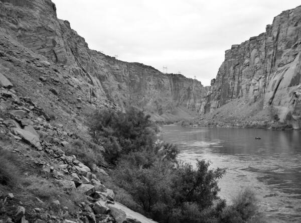
Repeat photograph taken in 1992 of the Colorado River below Glen Canyon Dam, a match to the 1889 image by Nims from the Stanton Expedition
linkA USGS repeat photograph of Glen Canyon Dam taken on October 29, 1992, as a match to the 1889 Franklin Nims image of the site before the dam was built, at Colorado River mile -14.7, during the Stanton Expedition. The view is taken looking downstream below the dam, from river left. Stake (camera point) s2638 in the SBSC's Southwest Repeat Photography Collection.
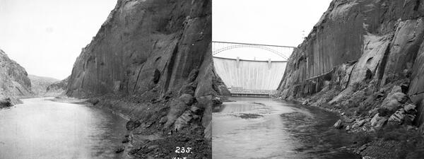
Glen Canyon Dam site before and after construction - repeat photos taken in 1889 and 1992
Side-by-side repeat photographic images of the Glen Canyon Dam site on the Colorado River. The first is a historic image taken on December 23, 1889, at River Mile Mile -14.7. The view is taken upstream from river left in 1889 by Franklin A. Nims during the Stanton Expedition. Original image courtesy of The National Archives, #57-RS-235, public domain.
Side-by-side repeat photographic images of the Glen Canyon Dam site on the Colorado River. The first is a historic image taken on December 23, 1889, at River Mile Mile -14.7. The view is taken upstream from river left in 1889 by Franklin A. Nims during the Stanton Expedition. Original image courtesy of The National Archives, #57-RS-235, public domain.
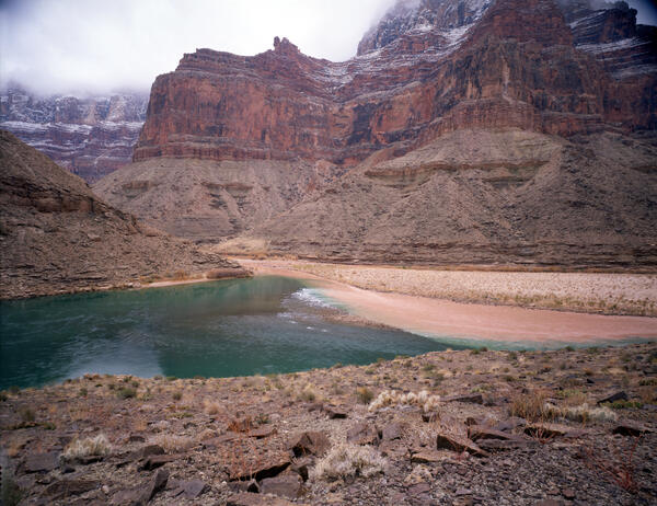
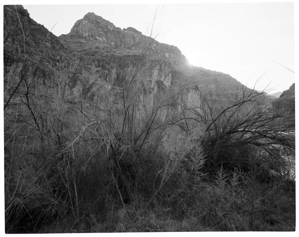
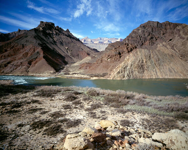
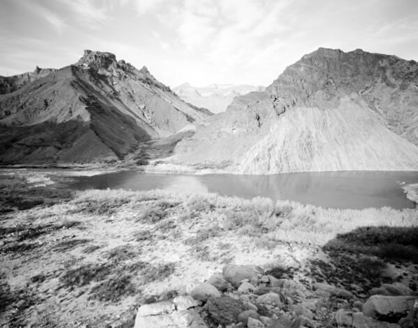
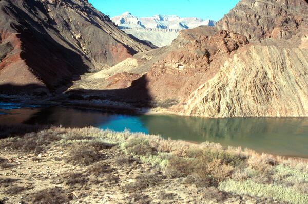
Colorado River, Grand Canyon, River Mile 61.4, Little Colorado River, Across Canyon View from River Right, 1992
linkJanuary 5, 1992: Colorado River, Grand Canyon, River Mile 61.4, Little Colorado River, Across Canyon View from River Right. Low clouds and snow blanketed the cliffs opposite the camera station when this image was taken, creating difficult matching conditions.
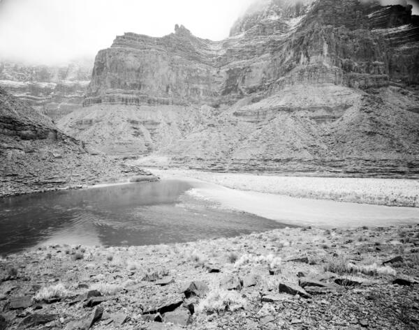
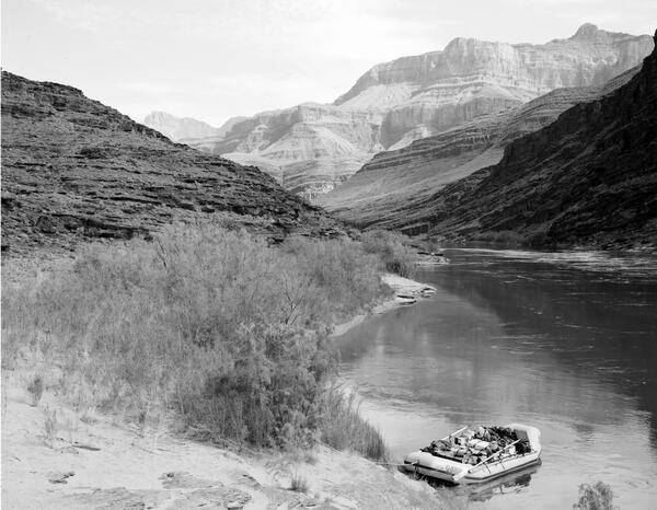
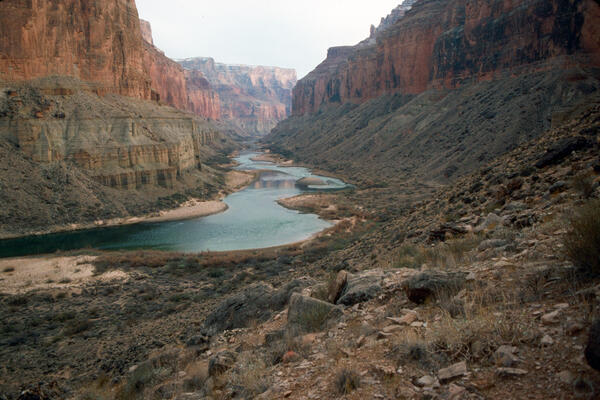
Repeat photograph of a boat on a beach along the Colorado River in Grand Canyon, 1991
This repeat photograph was taken in 1991 by Dave Edwards, USGS, along the Colorado River, and is a match of a historic image by E.C. LaRue from the 1923 Birdseye Expedition through Grand Canyon. The Birdseye Expedition surveyed a 251-mile stretch of the Colorado River from Lees Ferry to Diamond Creek.
This repeat photograph was taken in 1991 by Dave Edwards, USGS, along the Colorado River, and is a match of a historic image by E.C. LaRue from the 1923 Birdseye Expedition through Grand Canyon. The Birdseye Expedition surveyed a 251-mile stretch of the Colorado River from Lees Ferry to Diamond Creek.
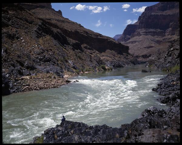
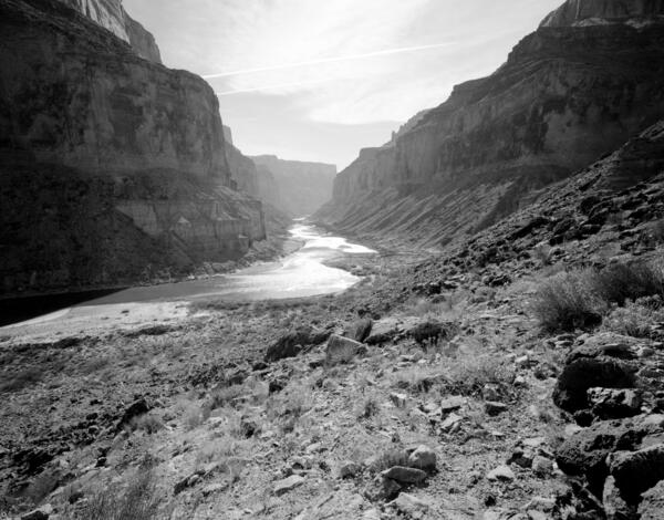
128-Mile Rapid on the Colorado River in Grand Canyon
128-Mile Rapid on the Colorado River in Grand Canyon. Photo by Teo Melis, USGS SBSC. This photo is a repeat photo match to a 1923 image by E.C. LaRue.
128-Mile Rapid on the Colorado River in Grand Canyon. Photo by Teo Melis, USGS SBSC. This photo is a repeat photo match to a 1923 image by E.C. LaRue.
Colorado River, Grand Canyon, River Mile 65.5, Palisades Creek, Across Canyon View from River Left, 1991
linkFebruary 6, 1991: Colorado River, Grand Canyon, River Mile 65.5, Palisades Creek, across canyon view from river left. Lava Canyon Rapid has changed considerably, owing to one or more debris flows over the past century from both sides of the river.
Colorado River, Grand Canyon, River Mile 65.5, Palisades Creek, Across Canyon View from River Left, 1991
linkFebruary 6, 1991: Colorado River, Grand Canyon, River Mile 65.5, Palisades Creek, Across Canyon View from River Left. Lava Canyon Rapid has changed considerably, owing to one or more debris flows over the past century from both sides of the river.
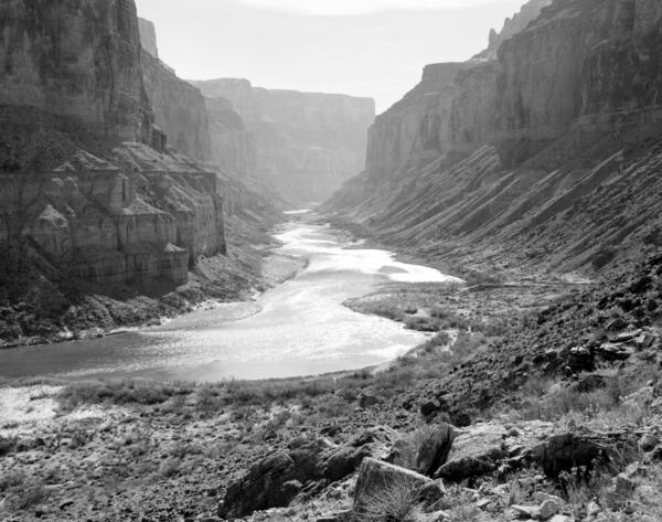
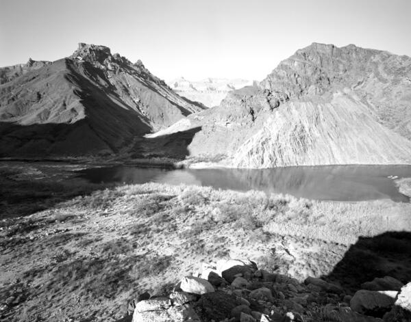
Colorado River, Grand Canyon, River Mile 52.8, Nankoweap, Downstream View from River Right, 1991
linkFebruary 5, 1991: Colorado River, Grand Canyon, River Mile 52.8, Nankoweap, Downstream View from River Right. The river level is higher than it was in the original photograph, but the sand bars appear to have shifted and eroded; mesquite has increased, but not as much as the non-native tamarisk. Many of the Mormon tea plants visible in 1890 persist. Stake no.
Colorado River, Grand Canyon, River Mile 52.8, Nankoweap, Downstream View from River Right, 1991
linkFebruary 5, 1991. Colorado River, Grand Canyon, River Mile 52.8, Nankoweap, Downstream View from River Right. The river level is higher than it was 1890, and overall the amount of sand lining the river has declined or is now covered with riparian vegetation. Some of the sand bars appear to have shifted and aggraded.
Colorado River, Grand Canyon, River Mile 65.5, Palisades Creek, Across Canyon View from River Left, 1990
linkColorado River, Grand Canyon, River Mile 65.5, Palisades Creek, Across Canyon View from River Left. Stake no. s1434 in the Southwest Repeat Photography Collection. Photo by Glenn Rink.
Colorado River, Grand Canyon, River Mile 65.5, Palisades Creek, Across Canyon View from River Left, 1990
linkColorado River, Grand Canyon, River Mile 65.5, Palisades Creek, Across Canyon View from River Left. Stake no. s1434 in the Southwest Repeat Photography Collection. Photo by Glenn Rink.
Colorado River, Grand Canyon, River Mile 65.5, Palisades Creek, Across Canyon View from River Left, 1990
linkJanuary 24, 1990: Colorado River, Grand Canyon, River Mile 65.5, Palisades Creek, across canyon view from River left. Stake no. s1434 in the Southwest Repeat Photography Collection. Photo by Glenn Rink.
Colorado River, Grand Canyon, River Mile 52.8, Nankoweap, Downstream View from River Right, 1990
linkJanuary 23, 1990: Colorado River, Grand Canyon, River Mile 52.8, Nankoweap, Downstream View from River Right. Stake no. 1424b in the Southwest Repeat Photography Collection. Photo by Robert H. Webb.
Colorado River, Grand Canyon, River Mile 52.8, Nankoweap, Downstream View from River Right, 1990
linkJanuary 23, 1990: Colorado River, Grand Canyon, River Mile 52.8, Nankoweap, Downstream View from River Right. Stake no. 1424b in the Southwest Repeat Photography Collection. Photo by Robert H. Webb.