
A Graceful Crab (Metacarcinus gracilis) captured in a beach seine during a 2012 Bainbridge Island larval forage fish survey. This survey focused on the abundance, habitat use, and food habits of larval forage fish (surf smelt and sand lance) and was conducted by scientists from the Columbia River Research Laboratory -Western Fisheries R
Images
Below are images associated with SBSC's science and staff. Images appear according to the year they were taken. To search, type a keyword or select a year from the dropdown menu. Or, click through the pages using the arrows at the bottom of the page.
Filter Total Items: 492

Graceful Crab in Puget Sound
A Graceful Crab (Metacarcinus gracilis) captured in a beach seine during a 2012 Bainbridge Island larval forage fish survey. This survey focused on the abundance, habitat use, and food habits of larval forage fish (surf smelt and sand lance) and was conducted by scientists from the Columbia River Research Laboratory -Western Fisheries R

Red Rock Crab in Puget Sound
A Red Rock Crab (Romaleon antennarium) captured in a beach seine during a 2012 Bainbridge Island larval forage fish survey. This survey focused on the abundance, habitat use, and food habits of larval forage fish (surf smelt and sand lance) and was conducted by scientists from the Columbia River Research Laboratory -Western Fisheries Re
A Red Rock Crab (Romaleon antennarium) captured in a beach seine during a 2012 Bainbridge Island larval forage fish survey. This survey focused on the abundance, habitat use, and food habits of larval forage fish (surf smelt and sand lance) and was conducted by scientists from the Columbia River Research Laboratory -Western Fisheries Re
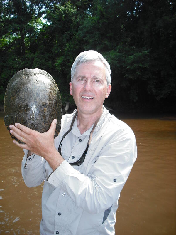
Dr. Jeff Lovich holds an Eastern river cooter turtle in the Pea River in Alabama
Dr. Jeff Lovich stands in the Pea River in Alabama holding an Eastern river cooter turtle (Pseudemys concinna concinna), May 2012.
Dr. Jeff Lovich stands in the Pea River in Alabama holding an Eastern river cooter turtle (Pseudemys concinna concinna), May 2012.

Panorama of Lake Powell with a stormy sky
Panorama of Lake Powell with a stormy sky. Photo by SBSC, Grand Canyon Monitoring and Research Center during a water quality monitoring trip.
Panorama of Lake Powell with a stormy sky. Photo by SBSC, Grand Canyon Monitoring and Research Center during a water quality monitoring trip.

A Rainbow Trout Rests Among Cobble Substrate in Panther Creek
A rainbow trout rests among cobble substrate in Panther Creek downstream of Big Deer Creek, central Idaho. Panther Creek was severely damaged by heavy metals released from mining and milling activities at the former Blackbird Mine, and water quality in this section of the stream was acutely lethal to fish as late as 1985.
A rainbow trout rests among cobble substrate in Panther Creek downstream of Big Deer Creek, central Idaho. Panther Creek was severely damaged by heavy metals released from mining and milling activities at the former Blackbird Mine, and water quality in this section of the stream was acutely lethal to fish as late as 1985.
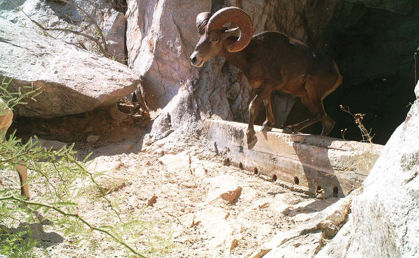
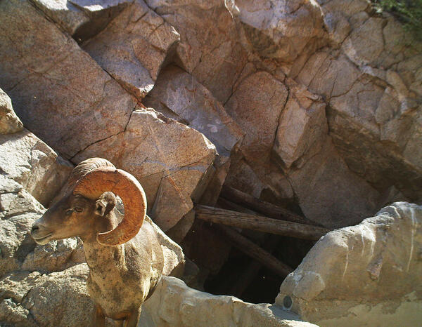
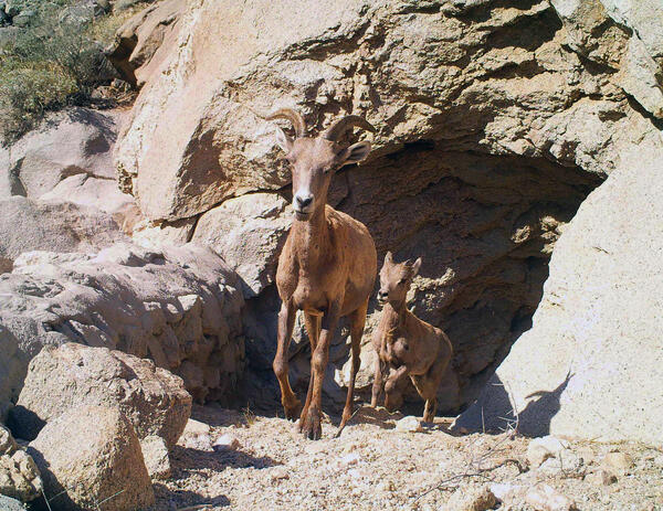
Bighorn sheep emerging from a tinaja water catchment in Cabeza Prieta National Wildlife Refuge, AZ
linkBighorn sheep emerging from the Eagle Tank water catchment, called a tinaja, in Cabeza Prieta National Wildlife Refuge (CPNWR), southern AZ. Photo courtesy of US Fish and Wildlife Service, CPNWR.
Bighorn sheep emerging from a tinaja water catchment in Cabeza Prieta National Wildlife Refuge, AZ
linkBighorn sheep emerging from the Eagle Tank water catchment, called a tinaja, in Cabeza Prieta National Wildlife Refuge (CPNWR), southern AZ. Photo courtesy of US Fish and Wildlife Service, CPNWR.
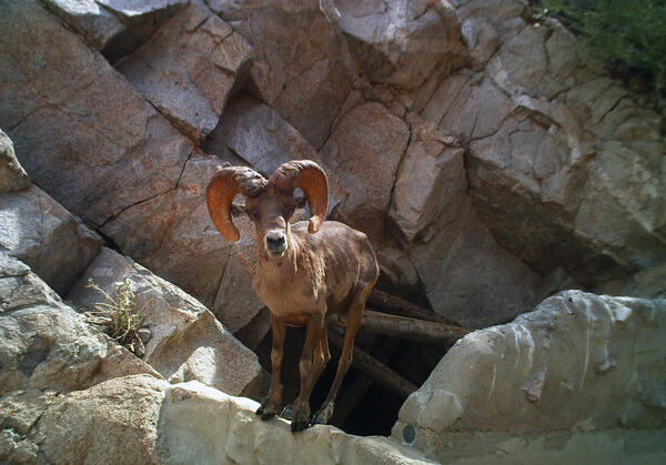
A bighorn sheep stands on the edge of a tinaja water catchment, Cabeza Prieta National Wildlife Refuge, AZ
linkA bighorn sheep stands on the edge of the Senita Tank water catchment, also called a tinaja, in Cabeza Prieta National Wildlife Refuge (CPNWR), southern AZ. Photo courtesy of US Fish and Wildlife Service, CPNWR.
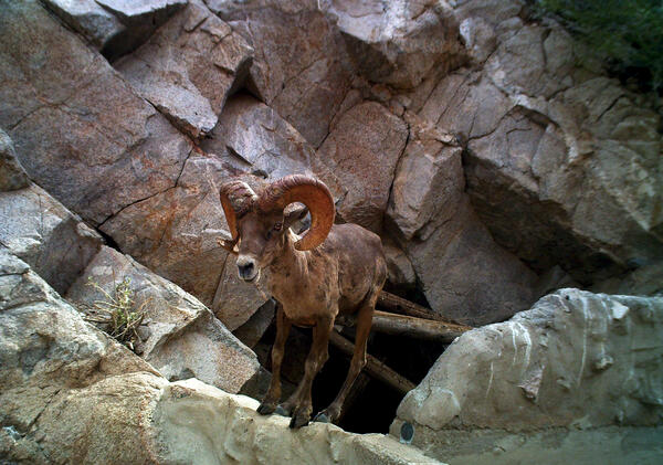
A bighorn sheep stands on the edge of a tinaja water catchment in Cabeza Prieta National Wildlife Refuge, AZ
linkA bighorn sheep stands on the edge of the Senita Tank water catchment, called a tinaja, in Cabeza Prieta National Wildlife Refuge (CPNWR), southern AZ. Photo courtesy of US Fish and Wildlife Service, CPNWR.
A bighorn sheep stands by a tinaja water catchment, Cabeza Prieta National Wildlife Refuge, AZ
A bighorn sheep stands by the Senita Tank water catchment, also called a tinaja, in Cabeza Prieta National Wildlife Refuge (CPNWR), southern AZ. Photo courtesy of the US Fish and Wildlife Service, CPNWR.
A bighorn sheep stands by the Senita Tank water catchment, also called a tinaja, in Cabeza Prieta National Wildlife Refuge (CPNWR), southern AZ. Photo courtesy of the US Fish and Wildlife Service, CPNWR.
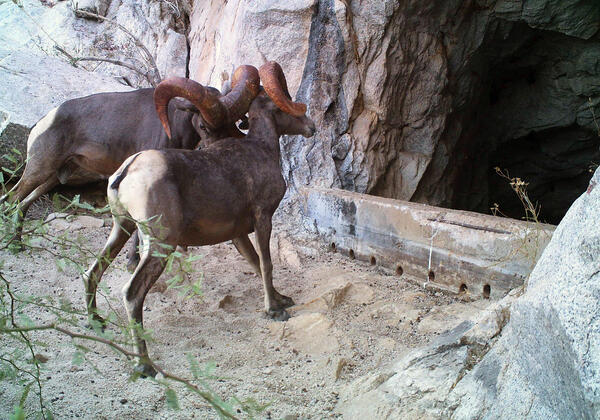
Two bighorn sheep butt heads next to a tinaja water catchment, Cabeza Prieta National Wildlife Refuge, AZ
linkTwo bighorn sheep butt heads next to the Eagle Tank water catchment, called a tinaja, at Cabeza Prieta National Wildlife Refuge, southern AZ. Photo courtesy of the US Fish and Wildlife Service, CPNWR.

Cattle walking across biological soil crusts in southeastern Utah
Cattle walking across biological soil crusts in southeastern Utah.
Cattle walking across biological soil crusts in southeastern Utah.

Dry conditions at cattle water sources in western Colorado
Dry conditions at cattle water sources in western Colorado.
Dry conditions at cattle water sources in western Colorado.
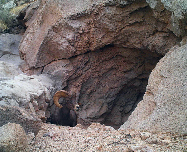
A bighorn sheep emerges from a tinaja water catchment, Cabeza Prieta National Wildlife Refuge, AZ
linkA bighorn sheep emerges from the Buck Tank water catchment, called a tinaja, at Cabeza Prieta National Wildlife Refuge (CPNWR), southern AZ. Photo courtesy of the US Fish and Wildlife Service, CPNWR.
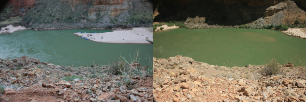
Same sandbar in 2008 and in 2011 in the Colorado River, Grand Canyon
Photograph of sandbar about 45 miles downstream from Lees Ferry, Arizona showing river party camping on large sandbar deposited by the 2008 high-flow experiment (left) and again in August 2011 (right) when the size of the sandbar and campsite was much smaller. USGS photos, public domain.
Photograph of sandbar about 45 miles downstream from Lees Ferry, Arizona showing river party camping on large sandbar deposited by the 2008 high-flow experiment (left) and again in August 2011 (right) when the size of the sandbar and campsite was much smaller. USGS photos, public domain.
Two bighorn sheep emerge from a tinaja water catchment in Cabeza Prieta National Wildlife Refuge, AZ
linkTwo bighorn sheep emerge from Buck Tank water catchment, called a tinaja, in Cabeza Prieta National Wildlife Refuge (CPNWR), southern Arizona. Photo courtesy of the US Fish and Wildlife Service, CPNWR.

Repeat photograph taken in 2011 of the Colorado River below Glen Canyon Dam, a match to the 1889 Stanton Expedition & 1992 USGS images
linkA USGS repeat photograph of Glen Canyon Dam taken on April 20, 2011, as a match to the 1889 Franklin Nims image of the site before the dam was built, at Colorado River mile -14.7, during the Stanton Expedition. This view was also matched in 1992 by the USGS. The view is taken looking downstream below the dam, from river left.

Repeat color photograph taken in 2011 of Glen Canyon Dam, a match to the 1889 Stanton Expedition & 1992 USGS images
linkA USGS repeat photograph of Glen Canyon Dam taken on April 20, 2011 as a match to the 1889 Franklin Nims image of the site before the dam was built, at Colorado River mile -14.7, during the Stanton Expedition. This view was also matched in 1992 by the USGS. The view is taken upstream from river left.

Saguaro cacti on a rocky slope in the Sonoran Desert, AZ
Steep, rocky slopes in Saguaro National Park near Tucson, AZ provide habitat for saguaros and may buffer populations from the negative effects of drought. Photo courtesy of Daniel Winkler, USGS SBSC.
Steep, rocky slopes in Saguaro National Park near Tucson, AZ provide habitat for saguaros and may buffer populations from the negative effects of drought. Photo courtesy of Daniel Winkler, USGS SBSC.

Repeat photograph of Saguaro National Monument East, Rincon Mountain District, 2010 (black and white version)
linkRepeat photograph of Saguaro National Monument (now Saguaro National Park) East, Rincon Mountain District. This photo was taken in 2010 by Dr. Ray Turner, USGS and is a match of a 1935 photograph taken by the National Park Service (NPS).

A National Park Service employee holds a brown trout in Grand Canyon
USFWS and USGS partner on brown trout research in Grand Canyon's Colorado River. This trout was removed from Bright Angel Creek, a tributary of the Colorado River. Photo courtesy of Brian Healy, formerly with National Park Service, Grand Canyon National Park, and now with USGS.
USFWS and USGS partner on brown trout research in Grand Canyon's Colorado River. This trout was removed from Bright Angel Creek, a tributary of the Colorado River. Photo courtesy of Brian Healy, formerly with National Park Service, Grand Canyon National Park, and now with USGS.

Electrofishing in a tributary in Grand Canyon
Electrofishing in a tributary in Grand Canyon to remove non-native fish. Photo courtesy of Brian Healy, formerly with National Park Service, Grand Canyon National Park, and now with USGS.
Electrofishing in a tributary in Grand Canyon to remove non-native fish. Photo courtesy of Brian Healy, formerly with National Park Service, Grand Canyon National Park, and now with USGS.