
Tribal youth participants on a 2021 USGS Partners-in-Science river trip enjoying dinner during the last night of their trip through the Grand Canyon. Diamond Peak is in the background. Photo credit: Sarah Spaulding, USGS/WRD.
Images
Below are images associated with SBSC's science and staff. Images appear according to the year they were taken. To search, type a keyword or select a year from the dropdown menu. Or, click through the pages using the arrows at the bottom of the page.
Filter Total Items: 406

Tribal youth participants on a 2021 USGS SBSC Partners-in-Science Colorado River trip
Tribal youth participants on a 2021 USGS Partners-in-Science river trip enjoying dinner during the last night of their trip through the Grand Canyon. Diamond Peak is in the background. Photo credit: Sarah Spaulding, USGS/WRD.

Grand Canyon Colorado River Airborne Imagery Tenth Mile Cover graph
Example graph of land cover calculations derived from remote sensing airborne image analysis for 0.1-mile segments of the Colorado River from Glen Canyon Dam to Diamond Creek. The percentage of the river valley covered by water (at 8,000 CFS river discharge), sand, vegetation, and other landcover are plotted for each 0.1-mile segment of the river.
Example graph of land cover calculations derived from remote sensing airborne image analysis for 0.1-mile segments of the Colorado River from Glen Canyon Dam to Diamond Creek. The percentage of the river valley covered by water (at 8,000 CFS river discharge), sand, vegetation, and other landcover are plotted for each 0.1-mile segment of the river.

RestoreNet restoration teatments in the Sonoran Desert
RestoreNet treatments include soil pits and connectivity modifiers (ConMods), seen here at a RestoreNet site in the Sonoran Desert.
RestoreNet treatments include soil pits and connectivity modifiers (ConMods), seen here at a RestoreNet site in the Sonoran Desert.

Lichen on rock, Moab, Utah - biocrust study
This photo of lichen was taken by SBSC in Moab, Utah as part of a biocrust study in 2021. Photo courtesy of Erika Geiger, USGS.
This photo of lichen was taken by SBSC in Moab, Utah as part of a biocrust study in 2021. Photo courtesy of Erika Geiger, USGS.

Restoration at Tsegi Canyon
Restoration project at Tsegi Canyon in support of cultural and ecological resources. It was a community project that brought together agency professionals, elders and native youth. This was a partnership with Navajo Nation and USGS Restoration Assessment and Monitoring Program for the Southwest.
Restoration project at Tsegi Canyon in support of cultural and ecological resources. It was a community project that brought together agency professionals, elders and native youth. This was a partnership with Navajo Nation and USGS Restoration Assessment and Monitoring Program for the Southwest.
Tsegi_Logo.jpg
The Restoration Assessment and Monitoring Program for the Southwest (RAMPS) is working with the Navajo Nation Department of Natural Heritage to build capacity for ecosystem restoration in response to climate change and drought.
The Restoration Assessment and Monitoring Program for the Southwest (RAMPS) is working with the Navajo Nation Department of Natural Heritage to build capacity for ecosystem restoration in response to climate change and drought.

SeedIncrease.6.jpg
The Restoration Assessment and Monitoring Program for the Southwest (RAMPS) is supporting the Dine Native Plant Program on the Navajo Nation with increasing the supply of locally adapted native seeds for restoration.
The Restoration Assessment and Monitoring Program for the Southwest (RAMPS) is supporting the Dine Native Plant Program on the Navajo Nation with increasing the supply of locally adapted native seeds for restoration.

A wetland area by Boulder Mountain, Utah, on a cloudy day in autumn
A wetland area by Boulder Mountain, Utah, on a cloudy day in the fall, with autumn colors in the trees. Photo taken in September 2021 by Shannon Lencioni, SBSC, USGS.
A wetland area by Boulder Mountain, Utah, on a cloudy day in the fall, with autumn colors in the trees. Photo taken in September 2021 by Shannon Lencioni, SBSC, USGS.

Shrubland that has been grazed near Boulder Mountain, Utah
Shrubland that has been grazed near Boulder Mountain, Utah, during sunset, September 2021. Photo by Shannon Lencioni, SBSC, USGS.
Shrubland that has been grazed near Boulder Mountain, Utah, during sunset, September 2021. Photo by Shannon Lencioni, SBSC, USGS.

Cactus blossom in the borderlands
Cactus blossom in the southeast Arizona grasslands, looking into Mexico.
Cactus blossom in the southeast Arizona grasslands, looking into Mexico.
Cactus blossom in the borderlands
Cactus blossom in the southeast Arizona grasslands, looking into Mexico.
Cactus blossom in the southeast Arizona grasslands, looking into Mexico.

Brown trout (Salmo trutta)
A photo of brown trout (Salmo trutta). Original image was from USGS NY Water Science Center, public domain.
A photo of brown trout (Salmo trutta). Original image was from USGS NY Water Science Center, public domain.

SBSC technician collects native seeds for data collecting and restoration near Moab, Utah
SBSC technician Morgan Andrews collects native hairy false goldenaster (Heterotheca villosa) seeds for data and restoration research near Moab, UT in September 2021. Photo by Shannon Lencioni, SBSC, USGS.
SBSC technician Morgan Andrews collects native hairy false goldenaster (Heterotheca villosa) seeds for data and restoration research near Moab, UT in September 2021. Photo by Shannon Lencioni, SBSC, USGS.

Colorado Plateau dryland habitat
Degraded dryland habitat on the Colorado Plateau. Photo by Shannon Lencioni, SBSC, USGS.
Degraded dryland habitat on the Colorado Plateau. Photo by Shannon Lencioni, SBSC, USGS.
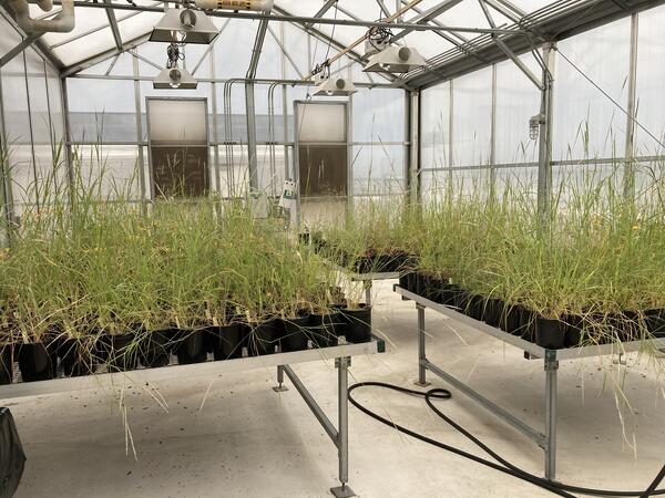
Greenhouse study comparing plant provenance for restoration
RestoreNet is partnering with the Gornish lab at the University of Arizona to better understand how a plant’s source location (provenance) influences its performance in a restoration setting. This greenhouse experiment will be conducted by PhD student, Sierra Lauman.
RestoreNet is partnering with the Gornish lab at the University of Arizona to better understand how a plant’s source location (provenance) influences its performance in a restoration setting. This greenhouse experiment will be conducted by PhD student, Sierra Lauman.

A panorama of Cathedral Valley, Capital Reef National Park, Utah
A panorama of Cathedral Valley, Capital Reef National Park, Utah. Photo by Chris Benson, USGS, 2021.
A panorama of Cathedral Valley, Capital Reef National Park, Utah. Photo by Chris Benson, USGS, 2021.

Cathedral Valley, Capital Reef National Park, Utah
Cathedral Valley, Capital Reef National Park, Utah. Photo by Chris Benson, USGS.
Cathedral Valley, Capital Reef National Park, Utah. Photo by Chris Benson, USGS.

Incubation experiment with Colorado River water and sediment
Clear glass incubation bottles with Colorado River water and sediment for an experiment on phosphorus cycling
Clear glass incubation bottles with Colorado River water and sediment for an experiment on phosphorus cycling

Heavily grazed Colorado Plateau pinyon-juniper dryland habitat
Heavily grazed pinyon-juniper habitat on the Colorado Plateau. Photo by Shannon Lencioni, SBSC, USGS.
Heavily grazed pinyon-juniper habitat on the Colorado Plateau. Photo by Shannon Lencioni, SBSC, USGS.

Pre-construction monitoring of vegetation for the Gemini Solar Array
The United States is developing renewable energy resources, especially solar, at a rapid rate.
The United States is developing renewable energy resources, especially solar, at a rapid rate.

Greenhouse study comparing plant performance during drought.
Greenhouse study comparing plant performance during drought will help land managers choose plant species for restoring degraded lands. To find out more, follow the Restoration Assessment and Monitoring Program of the Southwest, housed at the Southwest Biolobigical Science Center. www.ugs.gov/sbsc/ramps
Greenhouse study comparing plant performance during drought will help land managers choose plant species for restoring degraded lands. To find out more, follow the Restoration Assessment and Monitoring Program of the Southwest, housed at the Southwest Biolobigical Science Center. www.ugs.gov/sbsc/ramps