
Understanding of rockfall frequency-magnitude relationships is important for managing rockfall hazards, but characterizing these relationships is a challenging problem due to limited data, limited access, and the difficulty of accurately dating historic rockfalls.
All Multimedia
Access all multimedia to include images, video, audio, webcams, before-after imagery, and more. Filter and explore with filtering options to refine search.
Filter Total Items: 26025
")
Evaluating rockfall frequency from natural slopes (multiple methods)
Understanding of rockfall frequency-magnitude relationships is important for managing rockfall hazards, but characterizing these relationships is a challenging problem due to limited data, limited access, and the difficulty of accurately dating historic rockfalls.

USGS Outstanding in the Field, Episode 10, Bats
Welcome to the USGS Ecosystems Mission Area Outstanding in the Field podcast series that tells stories about our science, our adventures, and our efforts to better understand fish and wildlife and the ecosystems that support them.
Welcome to the USGS Ecosystems Mission Area Outstanding in the Field podcast series that tells stories about our science, our adventures, and our efforts to better understand fish and wildlife and the ecosystems that support them.

Nuvuk video camera 1 dark image
Two video cameras are installed atop a utility pole near the northernmost point of land in the United States at Nuvuk (Point Barrow), Alaska. The cameras point northwest toward the Arctic Ocean and the boundary between the Chukchi and Beaufort Seas. Every half hour during daylight hours, the cameras collect snapshots and video for 10 minutes.
Two video cameras are installed atop a utility pole near the northernmost point of land in the United States at Nuvuk (Point Barrow), Alaska. The cameras point northwest toward the Arctic Ocean and the boundary between the Chukchi and Beaufort Seas. Every half hour during daylight hours, the cameras collect snapshots and video for 10 minutes.

Nuvuk video camera 2 bright image
Two video cameras are installed atop a utility pole near the northernmost point of land in the United States at Nuvuk (Point Barrow), Alaska. The cameras point northwest toward the Arctic Ocean and the boundary between the Chukchi and Beaufort Seas. Every half hour during daylight hours, the cameras collect snapshots and video for 10 minutes.
Two video cameras are installed atop a utility pole near the northernmost point of land in the United States at Nuvuk (Point Barrow), Alaska. The cameras point northwest toward the Arctic Ocean and the boundary between the Chukchi and Beaufort Seas. Every half hour during daylight hours, the cameras collect snapshots and video for 10 minutes.

Nuvuk video camera 2 dark image
Two video cameras are installed atop a utility pole near the northernmost point of land in the United States at Nuvuk (Point Barrow), Alaska. The cameras point northwest toward the Arctic Ocean and the boundary between the Chukchi and Beaufort Seas. Every half hour during daylight hours, the cameras collect snapshots and video for 10 minutes.
Two video cameras are installed atop a utility pole near the northernmost point of land in the United States at Nuvuk (Point Barrow), Alaska. The cameras point northwest toward the Arctic Ocean and the boundary between the Chukchi and Beaufort Seas. Every half hour during daylight hours, the cameras collect snapshots and video for 10 minutes.

Pea Island video camera 1 snapshot
Two video cameras are temporarily mounted on a dune at Pea Island National Wildlife Refuge on the Outer Banks of North Carolina. The cameras are imaging the southern DUNEX (DUring Nearshore Event eXperiment) experiment site, and are designed to have a stereo view of the beach and potential overwash path until late October. Instruments from the U.S.
Two video cameras are temporarily mounted on a dune at Pea Island National Wildlife Refuge on the Outer Banks of North Carolina. The cameras are imaging the southern DUNEX (DUring Nearshore Event eXperiment) experiment site, and are designed to have a stereo view of the beach and potential overwash path until late October. Instruments from the U.S.

Pea Island video camera 2 snapshot
Two video cameras are temporarily mounted on a dune at Pea Island National Wildlife Refuge on the Outer Banks of North Carolina. The cameras are imaging the southern DUNEX (DUring Nearshore Event eXperiment) experiment site, and are designed to have a stereo view of the beach and potential overwash path until late October. Instruments from the U.S.
Two video cameras are temporarily mounted on a dune at Pea Island National Wildlife Refuge on the Outer Banks of North Carolina. The cameras are imaging the southern DUNEX (DUring Nearshore Event eXperiment) experiment site, and are designed to have a stereo view of the beach and potential overwash path until late October. Instruments from the U.S.

Nuvuk video camera 1 bright image
Two video cameras are installed atop a utility pole near the northernmost point of land in the United States at Nuvuk (Point Barrow), Alaska. The cameras point northwest toward the Arctic Ocean and the boundary between the Chukchi and Beaufort Seas. Every half hour during daylight hours, the cameras collect snapshots and video for 10 minutes.
Two video cameras are installed atop a utility pole near the northernmost point of land in the United States at Nuvuk (Point Barrow), Alaska. The cameras point northwest toward the Arctic Ocean and the boundary between the Chukchi and Beaufort Seas. Every half hour during daylight hours, the cameras collect snapshots and video for 10 minutes.

Nuvuk video camera 1 time exposure
Two video cameras are installed atop a utility pole near the northernmost point of land in the United States at Nuvuk (Point Barrow), Alaska. The cameras point northwest toward the Arctic Ocean and the boundary between the Chukchi and Beaufort Seas. Every half hour during daylight hours, the cameras collect snapshots and video for 10 minutes.
Two video cameras are installed atop a utility pole near the northernmost point of land in the United States at Nuvuk (Point Barrow), Alaska. The cameras point northwest toward the Arctic Ocean and the boundary between the Chukchi and Beaufort Seas. Every half hour during daylight hours, the cameras collect snapshots and video for 10 minutes.

Nuvuk video camera 1 variance image
Two video cameras are installed atop a utility pole near the northernmost point of land in the United States at Nuvuk (Point Barrow), Alaska. The cameras point northwest toward the Arctic Ocean and the boundary between the Chukchi and Beaufort Seas. Every half hour during daylight hours, the cameras collect snapshots and video for 10 minutes.
Two video cameras are installed atop a utility pole near the northernmost point of land in the United States at Nuvuk (Point Barrow), Alaska. The cameras point northwest toward the Arctic Ocean and the boundary between the Chukchi and Beaufort Seas. Every half hour during daylight hours, the cameras collect snapshots and video for 10 minutes.

Nuvuk video camera 2 snapshop
Two video cameras are installed atop a utility pole near the northernmost point of land in the United States at Nuvuk (Point Barrow), Alaska. The cameras point northwest toward the Arctic Ocean and the boundary between the Chukchi and Beaufort Seas. Every half hour during daylight hours, the cameras collect snapshots and video for 10 minutes.
Two video cameras are installed atop a utility pole near the northernmost point of land in the United States at Nuvuk (Point Barrow), Alaska. The cameras point northwest toward the Arctic Ocean and the boundary between the Chukchi and Beaufort Seas. Every half hour during daylight hours, the cameras collect snapshots and video for 10 minutes.

Nuvuk video camera 2 time exposure
Two video cameras are installed atop a utility pole near the northernmost point of land in the United States at Nuvuk (Point Barrow), Alaska. The cameras point northwest toward the Arctic Ocean and the boundary between the Chukchi and Beaufort Seas. Every half hour during daylight hours, the cameras collect snapshots and video for 10 minutes.
Two video cameras are installed atop a utility pole near the northernmost point of land in the United States at Nuvuk (Point Barrow), Alaska. The cameras point northwest toward the Arctic Ocean and the boundary between the Chukchi and Beaufort Seas. Every half hour during daylight hours, the cameras collect snapshots and video for 10 minutes.

Nuvuk video camera 2 variance image
Two video cameras are installed atop a utility pole near the northernmost point of land in the United States at Nuvuk (Point Barrow), Alaska. The cameras point northwest toward the Arctic Ocean and the boundary between the Chukchi and Beaufort Seas. Every half hour during daylight hours, the cameras collect snapshots and video for 10 minutes.
Two video cameras are installed atop a utility pole near the northernmost point of land in the United States at Nuvuk (Point Barrow), Alaska. The cameras point northwest toward the Arctic Ocean and the boundary between the Chukchi and Beaufort Seas. Every half hour during daylight hours, the cameras collect snapshots and video for 10 minutes.

Nuvuk video camera 1 snapshot
Two video cameras are installed atop a utility pole near the northernmost point of land in the United States at Nuvuk (Point Barrow), Alaska. The cameras point northwest toward the Arctic Ocean and the boundary between the Chukchi and Beaufort Seas. Every half hour during daylight hours, the cameras collect snapshots and video for 10 minutes.
Two video cameras are installed atop a utility pole near the northernmost point of land in the United States at Nuvuk (Point Barrow), Alaska. The cameras point northwest toward the Arctic Ocean and the boundary between the Chukchi and Beaufort Seas. Every half hour during daylight hours, the cameras collect snapshots and video for 10 minutes.


Kīlauea September 2021 Eruption

Photo Contest Winners August 2021
Winners
People: Sabina Perkins
USGS at Work: Meagan Eagle
Where We Work: Carly Venghaus
Honorable Mention 1: Rolando Garcia
Honorable Mention 2: Nick Grim
Winners
People: Sabina Perkins
USGS at Work: Meagan Eagle
Where We Work: Carly Venghaus
Honorable Mention 1: Rolando Garcia
Honorable Mention 2: Nick Grim

Photo Contest Winners September 2021
Winners
People: Jin-Si Over
USGS at Work: Joshua Woda
Where We Work: Elizabeth Nystrom
Honorable Mention 1: Dennis Adams
Honorable Mention 2: Sabina Perkins
Winners
People: Jin-Si Over
USGS at Work: Joshua Woda
Where We Work: Elizabeth Nystrom
Honorable Mention 1: Dennis Adams
Honorable Mention 2: Sabina Perkins
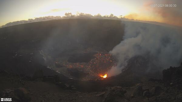
Recent changes at Kīlauea volcano - October 7, 2021
The USGS Hawaiian Volcano Observatory KWcam at Kīlauea's summit has captured changes within Halemaʻumaʻu crater, at Kīlauea's summit, due to the eruption that began on September 29, 2021. At approximately 3:21 pm, HST, new fissures opened at the base of Halemaʻumaʻu crater.
The USGS Hawaiian Volcano Observatory KWcam at Kīlauea's summit has captured changes within Halemaʻumaʻu crater, at Kīlauea's summit, due to the eruption that began on September 29, 2021. At approximately 3:21 pm, HST, new fissures opened at the base of Halemaʻumaʻu crater.

TNMCorps Mapping Challenge: Cemeteries in Western TN as of 10/14/21
A before-and-after image showing the change in edits between 10/07/21 and 10/14/21. Volunteers edited over 200 points during this timeframe (public domain).
A before-and-after image showing the change in edits between 10/07/21 and 10/14/21. Volunteers edited over 200 points during this timeframe (public domain).

TNMCorps Mapping Challenge: City/Town Halls in TX as of 10/14/21
A before-and-after image showing the change in edits between 10/07/21 and 10/14/21. Volunteers edited almost 100 points during this timeframe (public domain).
A before-and-after image showing the change in edits between 10/07/21 and 10/14/21. Volunteers edited almost 100 points during this timeframe (public domain).