
Bison
Since the late 19th century, the Department of the Interior, in collaboration with others, has been a leader in shared conservation stewardship of bison and manages...
Images
Explore our planet through photography and imagery, including climate change and water all the way back to the 1800s when the USGS was surveying the country by horse and buggy.
Filter Total Items: 21558

Department of the Interior Bison Conservation Initiative 2020
Bison
Since the late 19th century, the Department of the Interior, in collaboration with others, has been a leader in shared conservation stewardship of bison and manages...

Deployed Buoy
EMM68 buoy deployed on the Spruce Run Reservoir
EMM68 buoy deployed on the Spruce Run Reservoir

Yellowstone seismic network
Map of seismic stations in the Yellowstone region, with numbers of channels indicated by number and sensor type by color. Inverted triangles indicate stations operated by University of Utah Seismograph Stations (UUSS), and squares indicate stations operated by other agencies.
Map of seismic stations in the Yellowstone region, with numbers of channels indicated by number and sensor type by color. Inverted triangles indicate stations operated by University of Utah Seismograph Stations (UUSS), and squares indicate stations operated by other agencies.

Cessna Grand Caravan fixed-wing and an Airbus A350 B3 helicopter
Survey aircraft include a Cessna Grand Caravan fixed-wing and an Airbus A350 B3 helicopter with magnetometer stinger and towed bird respectively. Photos courtesy of Dewberry Engineers, Inc.
Survey aircraft include a Cessna Grand Caravan fixed-wing and an Airbus A350 B3 helicopter with magnetometer stinger and towed bird respectively. Photos courtesy of Dewberry Engineers, Inc.
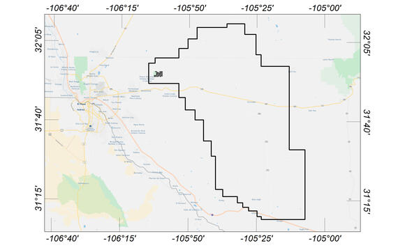
Flight area for Trans-Pecos aeromagnetic and radiometric survey
Map indicating flight area for Trans-Pecos aeromagnetic and radiometric survey. The survey area includes parts of El Paso and Hudspeth counties, Texas, and Otero County, New Mexico. Flights will begin in November 2020 and are expected to conclude in mid-January 2021.
Map indicating flight area for Trans-Pecos aeromagnetic and radiometric survey. The survey area includes parts of El Paso and Hudspeth counties, Texas, and Otero County, New Mexico. Flights will begin in November 2020 and are expected to conclude in mid-January 2021.

Juvenile Cisco in a Holding Tank at HBBS
Juvenile cisco (Coregonus artedi) swim in a tank at Hammond Bay Biological Station. The station hosts multiple researchers conducting projects to aid restoration of Great Lakes cisco populations.
Juvenile cisco (Coregonus artedi) swim in a tank at Hammond Bay Biological Station. The station hosts multiple researchers conducting projects to aid restoration of Great Lakes cisco populations.

Sligo Creek Storm
Photo Contest Winner | January 2021 | Honorable Mention 2
Sligo Creek Storm
Photo Contest Winner | January 2021 | Honorable Mention 2
Sligo Creek Storm

Chiropterologist coloring page
This is a high resolution image for the whiteboard series Chiropterologist coloring page.
By
This is a high resolution image for the whiteboard series Chiropterologist coloring page.
By

Elkhorn coral at calcification assessment station in Dry Tortugas
Established in 2009, the U.S. Geological Survey’s Coral Assessment Network (USGS-CAN) provides data on coral-growth (calcification) rates throughout the Florida Keys. Pictured here is one of 30 stations located in in Dry Tortugas National Park.
Established in 2009, the U.S. Geological Survey’s Coral Assessment Network (USGS-CAN) provides data on coral-growth (calcification) rates throughout the Florida Keys. Pictured here is one of 30 stations located in in Dry Tortugas National Park.

Wind turbines in California
Wind turbines at the San Gorgonio Pass Wind Resource Area north of Palm Springs in California.
Wind turbines at the San Gorgonio Pass Wind Resource Area north of Palm Springs in California.

EO1 grouping of ALI scenes
Several different ALI images grouped together.
Several different ALI images grouped together.

Map of Waiʻōhinu area, Island of Hawaiʻi
Map of Waiʻōhinu area, Island of Hawaiʻi, showing the location of the 3,740 year old age.
Map of Waiʻōhinu area, Island of Hawaiʻi, showing the location of the 3,740 year old age.

Upper Southwest Rift Zone of Kīlauea Volcano—October 22, 2020
View looking southwest along the Southwest Rift Zone of Kīlauea Volcano. The unvegetated nature of the Southwest Rift Zone is on full display with the Keanakākoʻi Tephra in the foreground overlying lava flows from Cone Peak (the cone in the middle ground to the right).
View looking southwest along the Southwest Rift Zone of Kīlauea Volcano. The unvegetated nature of the Southwest Rift Zone is on full display with the Keanakākoʻi Tephra in the foreground overlying lava flows from Cone Peak (the cone in the middle ground to the right).

Scientist holding brown treesnake
A USGS scientist holds an invasive brown treesnake.
A USGS scientist holds an invasive brown treesnake.

Black Oystercatcher on Gull Island, Alaska
Black Oystercatcher on Gull Island, Kachemak Bay, Alaska
Black Oystercatcher on Gull Island, Kachemak Bay, Alaska

Austin Chalk Core
Bedding features in the core from the USGS Gulf Coast #4 Bonham borehole, in the Eagle Ford Group mudstones from a depth of about 401 feet, Fannin County, Texas. The Eagle Ford Group lies underneath the Austin Chalk and serves as the source rock for much of the Austin Chalk's petroleum.
Bedding features in the core from the USGS Gulf Coast #4 Bonham borehole, in the Eagle Ford Group mudstones from a depth of about 401 feet, Fannin County, Texas. The Eagle Ford Group lies underneath the Austin Chalk and serves as the source rock for much of the Austin Chalk's petroleum.

Streamflow Measurement
Spread Creek streamflow measurement
Spread Creek streamflow measurement

USGS Technicians Prepare to Take a Core of the Austin Chalk in Texas
USGS technicians at the USGS Gulf Coast #4 Bonham borehole in preparation for geophysical logging of the Austin Chalk Group and the Eagle Ford Group mudstones, Fannin County, Texas.
USGS technicians at the USGS Gulf Coast #4 Bonham borehole in preparation for geophysical logging of the Austin Chalk Group and the Eagle Ford Group mudstones, Fannin County, Texas.

Old Faithful bathhouse during 1914-1933 (top) and 1934-1951 (bottom)
Old Faithful bathhouse as it appeared in 1914-1933 (top) and 1934-1951 (bottom).
Old Faithful bathhouse as it appeared in 1914-1933 (top) and 1934-1951 (bottom).

Collecting beach profile data in Science Festival video
This screenshot was taken from a video created for the virtual 2020 St. Petersburg Science Festival that discussed Coastal Change Hazards research at the USGS. Justin Birchler is seen walking up the beach with GPS equipment to measure the elevation of the beach.
This screenshot was taken from a video created for the virtual 2020 St. Petersburg Science Festival that discussed Coastal Change Hazards research at the USGS. Justin Birchler is seen walking up the beach with GPS equipment to measure the elevation of the beach.

Obsidian Cliff lava flow, Yellowstone
Photograph of Obsidian Cliff along Grand Loop Road between Norris and Mammoth Hot Springs. Photograph by John Good, U.S. National Park Service, 1965.
Photograph of Obsidian Cliff along Grand Loop Road between Norris and Mammoth Hot Springs. Photograph by John Good, U.S. National Park Service, 1965.