
During a gravity survey, HVO scientists measure the relative strength of gravity (gravimeter, bottom left corner of photo) between benchmarks. High-precision vertical positions from kinematic Global Positioning System (GPS, tripod and antenna middle of photo) help correct the gravity measurement for the effects of elevation changes.
Images
Explore our planet through photography and imagery, including climate change and water all the way back to the 1800s when the USGS was surveying the country by horse and buggy.
Filter Total Items: 21558

Kīlauea summit gravity survey - September 23, 2020
During a gravity survey, HVO scientists measure the relative strength of gravity (gravimeter, bottom left corner of photo) between benchmarks. High-precision vertical positions from kinematic Global Positioning System (GPS, tripod and antenna middle of photo) help correct the gravity measurement for the effects of elevation changes.

Kīlauea summit gravity survey - September 23, 2020
A gravimeter makes a measurement at a benchmark situated among lava flows erupted in 1919. The strength of gravity varies with both elevation and the amount of mass beneath the instrument. Changes in mass can indicate changes in the amount of magma entering Kīlauea's magma reservoirs. USGS photo by A. Flinders.
A gravimeter makes a measurement at a benchmark situated among lava flows erupted in 1919. The strength of gravity varies with both elevation and the amount of mass beneath the instrument. Changes in mass can indicate changes in the amount of magma entering Kīlauea's magma reservoirs. USGS photo by A. Flinders.

Kīlauea summit gravity survey - September 23, 2020
An HVO geophysicist takes a gravity measurement at a benchmark near a continuous gravimeter (inside hutch). The continuous gravimeter takes gravity measurements once per second and relays the data via radio back to HVO. During the gravity survey on September 23, 2020, HVO scientists took measurements at multiple locations on the floor of Kīlauea caldera.
An HVO geophysicist takes a gravity measurement at a benchmark near a continuous gravimeter (inside hutch). The continuous gravimeter takes gravity measurements once per second and relays the data via radio back to HVO. During the gravity survey on September 23, 2020, HVO scientists took measurements at multiple locations on the floor of Kīlauea caldera.
Kīlauea's summit water lake comparison - September 23, 2020
HVO geologists made observations of Kīlauea's summit water lake from the east rim of Halema‘uma‘u. This view point is on the large downdropped block that subsided during the 2018 collapse events. From this spot, a view of the entire lake is possible, providing a new perspective on the growth of the lake.
HVO geologists made observations of Kīlauea's summit water lake from the east rim of Halema‘uma‘u. This view point is on the large downdropped block that subsided during the 2018 collapse events. From this spot, a view of the entire lake is possible, providing a new perspective on the growth of the lake.

Kīlauea's water lake from the east side - September 23, 2020
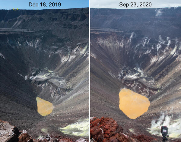
This view shows Kīlauea's water lake from the east side of the crater. On September 23, 2020, the western portion of the lake (top of image) was the most varied in color, with patches of greenish and brown water. The majority of the lake surface, however, was the typical tan hue. USGS photo by M. Patrick.
This view shows Kīlauea's water lake from the east side of the crater. On September 23, 2020, the western portion of the lake (top of image) was the most varied in color, with patches of greenish and brown water. The majority of the lake surface, however, was the typical tan hue. USGS photo by M. Patrick.

Kīlauea’s summit water lake and Crater Rim Drive - September 23, 2020
Portions of Crater Rim Drive, within Hawai‘i Volcanoes National Park, appear cracked, offset, and down-dropped in this photo, taken during an overflight of Kīlauea’s summit on September 23, 2020. To the north, Kīlauea’s summit water lake, within Halema‘uma‘u, is visible. USGS photo by K. Mulliken.
Portions of Crater Rim Drive, within Hawai‘i Volcanoes National Park, appear cracked, offset, and down-dropped in this photo, taken during an overflight of Kīlauea’s summit on September 23, 2020. To the north, Kīlauea’s summit water lake, within Halema‘uma‘u, is visible. USGS photo by K. Mulliken.


Low streamflow at USGS streamgage Young Womans Creek near Renovo, PA_2
Low streamflow in late September, 2020 at USGS streamgage Young Womans Creek near Renovo, Pennsylvania (01545600).
Low streamflow in late September, 2020 at USGS streamgage Young Womans Creek near Renovo, Pennsylvania (01545600).

Sulphur Banks area and Ha‘akulamanu trail
Hawaiian Volcano Observatory geologists flew over the Sulphur Banks area and Ha‘akulamanu trail within Hawai‘i Volcanoes National Park on September 23, 2020. Fumaroles in the Sulphur Banks area are sampled approximately every three months by Hawaiian Volcano Observatory gas geochemists to track long-term changes in volcanic gas chemistry at Kīlauea.
Hawaiian Volcano Observatory geologists flew over the Sulphur Banks area and Ha‘akulamanu trail within Hawai‘i Volcanoes National Park on September 23, 2020. Fumaroles in the Sulphur Banks area are sampled approximately every three months by Hawaiian Volcano Observatory gas geochemists to track long-term changes in volcanic gas chemistry at Kīlauea.

Wahinekapu (Steaming Bluff) and the Steam Vents area
The weather was overcast during an overflight of Kīlauea's summit on September 23, 2020. This view shows Wahinekapu (Steaming Bluff) and the Steam Vents area within Hawai‘i Volcanoes National Park. Extensive cracks in the area allow heated groundwater to escape from underground.
The weather was overcast during an overflight of Kīlauea's summit on September 23, 2020. This view shows Wahinekapu (Steaming Bluff) and the Steam Vents area within Hawai‘i Volcanoes National Park. Extensive cracks in the area allow heated groundwater to escape from underground.

Histology panel from eastern gray squirrel
Photomicrographs from the lung of an eastern gray squirrel (Sciurus carolinensis) found dead in Wisconsin, U.S.A. (A) A bronchiole (arrow) contains numerous neutrophils. H&E stain. Inset: Bronchiolar epithelium is overlain by Gram-negative bacteria. Brown and Hopps stain. Bar = 20 µm.
Photomicrographs from the lung of an eastern gray squirrel (Sciurus carolinensis) found dead in Wisconsin, U.S.A. (A) A bronchiole (arrow) contains numerous neutrophils. H&E stain. Inset: Bronchiolar epithelium is overlain by Gram-negative bacteria. Brown and Hopps stain. Bar = 20 µm.

Beach Profile Survey
Justin Birchler, Physical Scientist with the USGS Coastal Change Hazards team conducts a beach profile survey at our field site on Madeira Beach. During these surveys, Justin wears a backpack with GPS equipment to collect elevation data that will be used to create a topographic map of the beach.
Justin Birchler, Physical Scientist with the USGS Coastal Change Hazards team conducts a beach profile survey at our field site on Madeira Beach. During these surveys, Justin wears a backpack with GPS equipment to collect elevation data that will be used to create a topographic map of the beach.

Madeira Beach Camera Time Series
This photo is the results of processing a time series of images, which are a combination of all image frames collected during a 10 to 17-minute video. These images are incredibly useful for studying coastal change remotely, but the usefulness of the image depends on how they are processed.
This photo is the results of processing a time series of images, which are a combination of all image frames collected during a 10 to 17-minute video. These images are incredibly useful for studying coastal change remotely, but the usefulness of the image depends on how they are processed.

Pole Bridge Creek (2) sampled as part of RSQA
Pole Bridge Creek is one of the sites investigated in the USGS Regional Stream Quality Assessment, during which water quality and ecological condition were sampled.
Pole Bridge Creek is one of the sites investigated in the USGS Regional Stream Quality Assessment, during which water quality and ecological condition were sampled.

Sea Turtle Nest on Madeira Beach
The USGS Coastal Change Hazards team collects data to monitor coastal change – including how storms and waves shape and reshape our beaches. It’s important to keep track of how beaches change over time because they provide habitat for many creatures including birds and sea turtles, and they are beautiful locations where people love to live and vacation.
The USGS Coastal Change Hazards team collects data to monitor coastal change – including how storms and waves shape and reshape our beaches. It’s important to keep track of how beaches change over time because they provide habitat for many creatures including birds and sea turtles, and they are beautiful locations where people love to live and vacation.

Water Sampling at Soldier Meadows Spring Complex in Nevada
In September 2020, field crews in the USGS Nevada Water Science Center measured spring flow and collected water-quality samples at locations around the Soldier Meadows Spring Complex in Nevada. The spring complex is the only home of a small fish called the desert dace.
In September 2020, field crews in the USGS Nevada Water Science Center measured spring flow and collected water-quality samples at locations around the Soldier Meadows Spring Complex in Nevada. The spring complex is the only home of a small fish called the desert dace.

Shields River above Smith Cr near Wilsall, MT Streamgage (06192980)
Shields River above Smith Creek near Wilsall, MT (06192980)
Shields River above Smith Creek near Wilsall, MT (06192980)

The 9 millionth scene added to the USGS Landsat Archive
The USGS Landsat Archive added its 9 millionth scene to the archive on September 18, 2020. The scene was acquired by Landsat 8 over Northern Paraguay and is shown using bands 6,5,4.
The USGS Landsat Archive added its 9 millionth scene to the archive on September 18, 2020. The scene was acquired by Landsat 8 over Northern Paraguay and is shown using bands 6,5,4.

Aerial photos of barrier islands
We conduct fieldwork in a variety of barrier island settings to understand the relative importance of these factors, including Fire Island, NY; Rockaway, NY; Seven Mile Island, NJ; and Cedar Island, VA.
We conduct fieldwork in a variety of barrier island settings to understand the relative importance of these factors, including Fire Island, NY; Rockaway, NY; Seven Mile Island, NJ; and Cedar Island, VA.

Color variations at Kīlauea's summit water lake - 09/18/2020
Color variations are common at Kīlauea's summit water lake, and are usually dominated by tan and brown hues. Today, the interaction between different color zones produced a large swirl in the center of the lake.
Color variations are common at Kīlauea's summit water lake, and are usually dominated by tan and brown hues. Today, the interaction between different color zones produced a large swirl in the center of the lake.

USGS hydrologists respond to historic hurricane season
Throughout the historically active 2020 Atlantic Hurricane Season,USGS hydrologists have been working quickly to collect vital flood and streamflow information in impacted areas.
Throughout the historically active 2020 Atlantic Hurricane Season,USGS hydrologists have been working quickly to collect vital flood and streamflow information in impacted areas.