
This photograph is of the seafloor on the Rhode Island coast and shows a skate on a fine-grained, likely silty or muddy seafloor. This photograph was collected to support research and management activities (e.g., wind farms and fisheries) along the Rhode Island inner continental shelf.
Images
Explore our planet through photography and imagery, including climate change and water all the way back to the 1800s when the USGS was surveying the country by horse and buggy.
Filter Total Items: 21558

Rhode Island Seafloor
This photograph is of the seafloor on the Rhode Island coast and shows a skate on a fine-grained, likely silty or muddy seafloor. This photograph was collected to support research and management activities (e.g., wind farms and fisheries) along the Rhode Island inner continental shelf.

Woods Hole Passage
This photograph is of the seafloor in the Woods Hole Passage and shows a mussel reef and boring sponge.
This photograph is of the seafloor in the Woods Hole Passage and shows a mussel reef and boring sponge.

Stream Gage sits high and dry on the eastern shore of the Salton Sea
Stream gage #10254005 located near Westmorland, CA, on the eastern shore of the Salton Sea, now sits out of the water as the Salton Sea continues to evaporate and the shoreline retreats.
Stream gage #10254005 located near Westmorland, CA, on the eastern shore of the Salton Sea, now sits out of the water as the Salton Sea continues to evaporate and the shoreline retreats.

Coastal tailed frog male dorsal side, Brush Crk, OR
Coastal tailed frog male dorsal side, Brush Crk, OR
Coastal tailed frog male dorsal side, Brush Crk, OR

Photo of Spring Lake in San Marcos, Texas
Spring Lake in San Marcos, Texas, has hundreds of small springs underneath it.
A new website now provides important information about streamflow in the Comal and San Marcos Rivers and springflow at Comal and San Marcos Springs.
Spring Lake in San Marcos, Texas, has hundreds of small springs underneath it.
A new website now provides important information about streamflow in the Comal and San Marcos Rivers and springflow at Comal and San Marcos Springs.

Sunrise on Pompey Peak, Washington
Sunrise on Pompey Peak, Washington.
Sunrise on Pompey Peak, Washington.

Deploying the poking eyeball
USGS scientists from the Pacific Coastal and Marine Science Center (PCMSC) in Santa Cruz, California deploy an instrument called the poking eyeball. The system, developed by PCMSC, was designed to take repetitive microscopic images of the seabed from a tripod on the seafloor.
USGS scientists from the Pacific Coastal and Marine Science Center (PCMSC) in Santa Cruz, California deploy an instrument called the poking eyeball. The system, developed by PCMSC, was designed to take repetitive microscopic images of the seabed from a tripod on the seafloor.

Downstream Pembina River
The Pembina River at Neche, ND looking downstream.
The Pembina River at Neche, ND looking downstream.
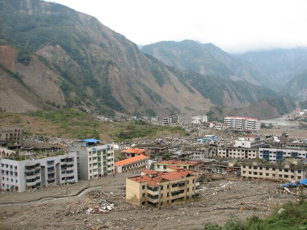
Damage from 2008 Great Sichuan Earthquake in China
The May 12, 2008, Great Sichuan Earthquake, also called the Wenchuan Earthquake, occurred at 14:28 local time, in Sichuan Province, China. The earthquake magnitudes were Mw = 7.9 (USGS), Ms = 8.0 (Chinese Earthquake Administration). The epicenter was 80 km west-northwest of Chengdu, the capital city of Sichuan province.
The May 12, 2008, Great Sichuan Earthquake, also called the Wenchuan Earthquake, occurred at 14:28 local time, in Sichuan Province, China. The earthquake magnitudes were Mw = 7.9 (USGS), Ms = 8.0 (Chinese Earthquake Administration). The epicenter was 80 km west-northwest of Chengdu, the capital city of Sichuan province.

Dissecting a Fish to Determine Possible Endocrine Disruption Effects
USGS scientist dissecting a fish to determine possible effects from exposure to endocrine disrupting contaminants.
USGS scientist dissecting a fish to determine possible effects from exposure to endocrine disrupting contaminants.

Red River of the North at Fargo ND
Red River of the North at Fargo, North Dakota in 2008.
Red River of the North at Fargo, North Dakota in 2008.

Equipment for an Bioaugmentation Experiment at the Naval Air Warfare Center (NAWC) Research Site, West Trenton, New Jersey
linkThe set up and equipment used for the bioaugmentation experiment at a fractured-rock contamination site. The site is contaminated with trichloroethene (TCE). The bladders contain the solutions that were injected into the subsurface. The injection well is right in front of the blue barrel.

USGS scientist dissecting a summer flounder
USGS scientist dissecting a summer flounder. Science Feature that the image was used on was Pesticides Common in California Estuary
USGS scientist dissecting a summer flounder. Science Feature that the image was used on was Pesticides Common in California Estuary

Blue Ridge Parkway With Fall Foliage
Climbing Waterrock Knob and viewing the Blue Ridge Pkwy below with the fall foliage around.
Climbing Waterrock Knob and viewing the Blue Ridge Pkwy below with the fall foliage around.

Blue Ridge Parkway With Fall Foliage
View of Blue Ridge Parkway foliage from Waterrock Knob.
View of Blue Ridge Parkway foliage from Waterrock Knob.

Fall Foliage Along Blue Ridge Parkway
View of Blue Ridge Parkway foliage from Waterrock Knob at sunset.
View of Blue Ridge Parkway foliage from Waterrock Knob at sunset.

Fall Foliage Along Blue Ridge Parkway
View of Blue Ridge Parkway foliage from Waterrock Knob at sunset.
View of Blue Ridge Parkway foliage from Waterrock Knob at sunset.

Fall Foliage Along Blue Ridge Parkway
Bright fall foliage along the Blue Ridge Parkway.
Bright fall foliage along the Blue Ridge Parkway.

Fall Foliage along Blue Ridge Parkway
Bright fall foliage along the Blue Ridge Parkway.
Bright fall foliage along the Blue Ridge Parkway.

Fall Foliage From Waterrock Knob
View from Summit of Waterrock Knob at 6,292 feet. It is the 16th highest peak in the Eastern US and located within the Blue Ridge Pkwy.
View from Summit of Waterrock Knob at 6,292 feet. It is the 16th highest peak in the Eastern US and located within the Blue Ridge Pkwy.

Fall Foliage from Waterrock Knob
View of fall foliage from Waterrock Knob Mt. peak in the Plott Balsam Mt. chain.
View of fall foliage from Waterrock Knob Mt. peak in the Plott Balsam Mt. chain.