
Tarrabool Lake is a seasonal lake in Australia’s Northern Territory. While the lake’s water level fluctuates from year to year, its swampy wetlands and the surrounding tropical forested areas supports an essential habitat for small mammals, reptiles, and a wide variety of bird species.
Images
The National Land Imaging Program supports a variety of geospatial data programs and projects, including the USGS Landsat Program. Browse the images below to see some of the imagery produced using NLI-supported data sources.
Filter Total Items: 466

Tarrabool Lake, Northern Territory
Tarrabool Lake is a seasonal lake in Australia’s Northern Territory. While the lake’s water level fluctuates from year to year, its swampy wetlands and the surrounding tropical forested areas supports an essential habitat for small mammals, reptiles, and a wide variety of bird species.

Landsat Images of the Park Fire, July 2024
The Park Fire north of Sacramento in California forced thousands of residents to evacuate in late July as it spread to over 370,000 acres. The fire started on July 24th. Landsat 8 captured an image of the fire two days later.
The Park Fire north of Sacramento in California forced thousands of residents to evacuate in late July as it spread to over 370,000 acres. The fire started on July 24th. Landsat 8 captured an image of the fire two days later.

Landsat Reveals Cape Cod's Changing Coastlines
Ocean currents, and the sediments they transport, have constantly shifted the Cape Cod barrier islands over time. Some of the abrupt changes, however, can be linked directly to a storm.
Ocean currents, and the sediments they transport, have constantly shifted the Cape Cod barrier islands over time. Some of the abrupt changes, however, can be linked directly to a storm.

Australia has formally joined the United States-led Landsat Next satellite program
Minister for Foreign Affairs, Penny Wong, and U.S. Secretary of State, Antony Blinken, with the signed bilateral statement on the Landsat Next program.
Minister for Foreign Affairs, Penny Wong, and U.S. Secretary of State, Antony Blinken, with the signed bilateral statement on the Landsat Next program.

USGS and Australia formally partner for upcoming Landsat Next satellite mission
Alison Rose, Chief of Space Division, Geoscience Australia, and Darcee Killpack, acting Associate Director, Core Science Systems, United States Geological Survey, signing the Memorandum of Understanding formally operationalizing the Landsat Next partnership.
Alison Rose, Chief of Space Division, Geoscience Australia, and Darcee Killpack, acting Associate Director, Core Science Systems, United States Geological Survey, signing the Memorandum of Understanding formally operationalizing the Landsat Next partnership.

Australia has formally joined the Landsat Next satellite program
Minister for Foreign Affairs, Penny Wong, and U.S. Secretary of State, Antony Blinken, with the signed bilateral statement on the Landsat Next program.
Minister for Foreign Affairs, Penny Wong, and U.S. Secretary of State, Antony Blinken, with the signed bilateral statement on the Landsat Next program.
Infographic for Report "Economic Valuation of Landsat and Landsat Next 2023"
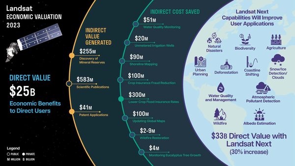
This infographic is from the report "Economic Valuation of Landsat and Landsat Next 2023," which shows that Landsat's direct value in 2023 was $25.6 billion. The report and infographic also show well over $1 billion in estimated indirect economic value.
This infographic is from the report "Economic Valuation of Landsat and Landsat Next 2023," which shows that Landsat's direct value in 2023 was $25.6 billion. The report and infographic also show well over $1 billion in estimated indirect economic value.

JACIE 2025 Workshop deadlines
The JACIE 2025 Workshop will be held April 7-11, 2025 at USGS Headquarters in Reston, Virginia. This graphic displays the deadlines for the workshop components.
Visit the JACIE 2025 Workshop webpage to learn more about the workshop.
The JACIE 2025 Workshop will be held April 7-11, 2025 at USGS Headquarters in Reston, Virginia. This graphic displays the deadlines for the workshop components.
Visit the JACIE 2025 Workshop webpage to learn more about the workshop.

2023 Earth Observations Assessment on Ag and Forestry Cover Image
The United States Group on Earth Observations (USGEO) 2023 Earth Observations Assessment Report on Agriculture and Forestry provides a quantitative assessment of the Nation’s then-current portfolio of Earth observations (data, measurements derived from the systems, platfo
The United States Group on Earth Observations (USGEO) 2023 Earth Observations Assessment Report on Agriculture and Forestry provides a quantitative assessment of the Nation’s then-current portfolio of Earth observations (data, measurements derived from the systems, platfo

NUSO researchers prepare for evaluation flights with a vertical take-off and landing UAS
NUSO researchers Matt Burgess and Mark Bauer prepare for evaluation flights with the WingtraOne GEN II vertical take-off and landing mapping UAS equipped with the newly released lidar payload.
NUSO researchers Matt Burgess and Mark Bauer prepare for evaluation flights with the WingtraOne GEN II vertical take-off and landing mapping UAS equipped with the newly released lidar payload.

JACIE 2025 Workshop Save the Date
JACIE 2025 will be held April 7 - 11, 2025 at USGS Headquarters in Reston, Virginia.
Annual JACIE Workshops are sponsored by government agencies and allow remote sensing experts to discuss system capabilities, calibration, and the impacts of data quality on various applications.
Highlights of JACIE Workshops include:

Landsat 9 Image of Phoenix Metropolitan Area
The Phoenix, Arizona metropolitan area, also known as the Valley of the Sun, is comprised of more than 14,600 square miles and is considered the largest metropolitan area in the southwestern United States. The desert climate and abundant sunshine of the area are main factors in population growth and urban sprawl.
The Phoenix, Arizona metropolitan area, also known as the Valley of the Sun, is comprised of more than 14,600 square miles and is considered the largest metropolitan area in the southwestern United States. The desert climate and abundant sunshine of the area are main factors in population growth and urban sprawl.

Railroad Valley Playa
The Railroad Valley Playa, located in east central Nevada, measures about 80 miles long and nearly 20 miles wide, and is a vast and wide-open landscape.
The Railroad Valley Playa, located in east central Nevada, measures about 80 miles long and nearly 20 miles wide, and is a vast and wide-open landscape.

National Ocean Month - Earth as Art
Each year, June is National Ocean Month!
Each year, June is National Ocean Month!

2023 Earth Observation Assessment for agriculture and forestry
Graphic showing Earth observation inputs found in the 2023 USGEO Earth observation assessment for agriculture and forestry.
Graphic showing Earth observation inputs found in the 2023 USGEO Earth observation assessment for agriculture and forestry.

Landsat 8 Image of Ayon Island
Landsat 8's Operational Land Imager (OLI) captured this icy view of Ayon Island on June 17, 2024. The island's low-lying tundra and the shorelines create a picturesque view from its high latitude location in the East Siberian Sea. This unique polar landmass is separated from the mainland by the Malyy Chaunskiy Strait.
Landsat 8's Operational Land Imager (OLI) captured this icy view of Ayon Island on June 17, 2024. The island's low-lying tundra and the shorelines create a picturesque view from its high latitude location in the East Siberian Sea. This unique polar landmass is separated from the mainland by the Malyy Chaunskiy Strait.

Landsat 9 View of Beaufort Sea Melt Ponds
This Landsat 9 image from June 13, 2024, shows the Beaufort Sea near Prudhoe Bay, Alaska, using the Shortwave Infrared, Near Infrared, and Reds (Band 6|5|4), and sharpened with the with Panchromatic band (Band 8). The cyan tones highlight sea ice and melt ponds, while the red areas represent land and vegetation.
This Landsat 9 image from June 13, 2024, shows the Beaufort Sea near Prudhoe Bay, Alaska, using the Shortwave Infrared, Near Infrared, and Reds (Band 6|5|4), and sharpened with the with Panchromatic band (Band 8). The cyan tones highlight sea ice and melt ponds, while the red areas represent land and vegetation.

Norwegian Ambassador visit to USGS EROS
Group photo during the Norwegian Ambassador's visit to EROS.
Group photo during the Norwegian Ambassador's visit to EROS.

USGS Deputy Director-Operations Cindy Lodge with DLR’s German Remote Sensing Data Center (DFD) Director professor Stefan Dech.
linkUSGS Deputy Director-Operations Cindy Lodge shown here with DLR’s German Remote Sensing Data Center (DFD) Director professor Stefan Dech at DLR’s Earth Observation Center in Oberpfaffenhofen finalizing the signatures on the statement of intent for the upcoming Landsat Next mission.

USGS and German Aerospace Center sign statement of intent for Landsat Next mission.
USGS and German Aerospace Center sign statement of intent for upcoming Landsat Next mission.
(Left to Right): Head of the DLR Space Division Dr. Anke Pagels-Kerp and USGS Deputy Director-Operations Cindy Lodge.
USGS and German Aerospace Center sign statement of intent for upcoming Landsat Next mission.
(Left to Right): Head of the DLR Space Division Dr. Anke Pagels-Kerp and USGS Deputy Director-Operations Cindy Lodge.

USGS and German Aerospace Center sign statement of intent for upcoming Landsat Next mission.
The U.S. Geological Survey and German Aerospace Center (Deutsches Zentrum für Luft-und Raumfahrt or DLR sign statement for plans to continue partnership with the upcoming Landsat Next satellite mission.
The U.S. Geological Survey and German Aerospace Center (Deutsches Zentrum für Luft-und Raumfahrt or DLR sign statement for plans to continue partnership with the upcoming Landsat Next satellite mission.